
| Previous Site | Next Site |
Earth Science Conservation Review
| Aghnadarragh | Antrim |
| Site number: | 1 | File Number: | J17 |
| ESCC: | IS | ||
| Locality Type: | Pit | Status: | ASSI |
| Grid Reference: | J130733 Approximate | ||
| Google maps: | 54.59575,-6.25169 | ||
| County: | Antrim | Council area: | Antrim & Newtownabbey Borough Council |
| Period: | Quaternary | ||
| Stages: | Early Midlandian, Late Midlandian, Middle Midlandian | ||
| Site Description | |
|---|---|
 | |
| Highlights: | |
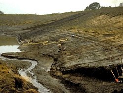
The pit face at Aghnadarragh contains the most complete stratigraphy known from the Midlandian Cold Stage in Ireland (McCabe et al., 1987). Well-exposed sections comprise a cake-like stratigraphy recording an early Midlandian ice advance, a long period of interstadial and cool conditions followed by the Late Midlandian glaciation. The non-glacial episodes represent a wide range of shallow water depositional settings recorded by detrital peats and a gravelly horizon rich in the remains of Mammuthus primigenius. | |
| Introduction: | |
The late Pleistocene succession of basal tills, organic deposits and stratified sediments was exposed in a pit excavated during lignite exploration near the eastern shore of Lough Neagh, Aghnadarragh townland, near Glenavy, Co Antrim. The pit is excavated in a flat, terrace-like feature (30m O.D.) which is up to 1.5km in width and parallels the lake shore as far north as Antrim town. To the east this flat ground is replaced abruptly by drumlin swarms which dominate the landscape around Glenavy. The Pleistocene deposits rest on glacitectonised woody lignites and clays (Watts, 1970) within the Lough Neagh depression which has subsided since Tertiary times (Wilson, 1972). The exposure consists of two major till sheets separated by stratified sediments which contain two distinct organic horizons. The sequences occur within two basins which are separated by a prominent ridge of glacitectonised lignite. Ten major lithological units are recognised, though not all of these are present in the western basin. Although this is the most complete Midlandian (last cold stage) sequence known in Great Britain, a series of non-sequences and erosion surfaces separate the upper units. The lithologic and biostratigraphic variability of the sequence points to a series of complex climatic oscillations with in the last cold stage, with development of lowland ice sheets only at the beginning and end of the cycle. A full account of the sequence is given in McCabe et al., (1987) and McCabe and Hirons, (1986). | |
| Description: | |
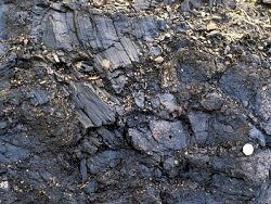 Unit 2. Lower Till Facies: A massive, tabular till unit up to 5m thick overlies the lignite. At its base it is strongly foliated consisting of subhorizontal stacked beds (20-40cm) of massive till, pebbly sand and pebbly gravel which dip east against the lignite ridge. Contacts are blurred but shear structures, smudges and slickensides are common. Clast fabrics range from 0° to 325°T with low dip angles. Clast composition is mainly basalt (<95%) with up to 1% of far- travelled erratics derived from the volcanic arc and ophiolitic assemblages of the Tyrone Igneous Complex. Unit 3. Massive Mud: A gradational, unweathered contact occurs between the lower till and overlying unfossiliferous, massive mud. Dispersed pebbles occur towards the top of the mud unit. 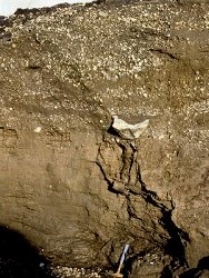 Unit 5. Interbedded Pebbly Gravel and Diamict: This composite unit is 4-5m thick and consists of very-poorly sorted, clast-to-matrix supported, pebbly gravel/granule beds (5-10cm) interbedded with silty and sandy diamicts. Beds are ungraded with reworked tops and are separated by both sharp and gradational contacts. Remains of Mammuthus primigenius are common within diamict lenses along with a sparce Arctic microflora. Infinite 14C dates (>44ka B.P.) were obtained from a mammoth tooth (McCabe et al., 1987) and recent 234-238U measurements provide dates of 89-96, 68-72, 72-75, 71-75 ka B.P. (Doughty, pers. comm., 1983). 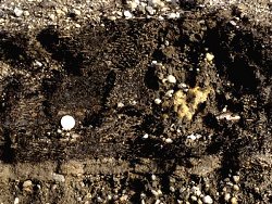 Unit 7. Interbedded Pebbly Sands, Gravels and Diamicts: This stacked sequence consists of rapidly alternating beds (10- 50cm) of pebbly sands, pebbly gravel and silt-rich diamicts. Units are massive and clast-to-matrix supported. Unit 8. Detrital Organic Mud: This occurs in the eastern basin as thin beds (1-4cm) interbedded with laminated sand. The palaeobotany reflects a local, treeless environment with Cyperaceae and Graminae dominating the pollen spectra. The insect fauna is dominated by species such as Diacheila arctica which occur today no nearer than Arctic Fenno- scandia. 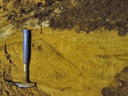 Unit 10. Upper Till Facies: Uppermost unit forming a 4-7m tabular drape of diamict across the section. The till is massive with numerous shear structures and is mainly derived from basalt (<93%) and chalk (<6%). It is note- worthy that the mineralogical composition of both till facies (2 and 10) is similar. | |
| Importance: | |
The Aghnadarragh sequence provides a unique Late Midlandian stratigraphic sequence which is highly important locally, nationally, internationally and in the formulation of geological concepts. The following attributes are recognised: a) This stratigraphic complexity and length of stratigraphic record is unique in G.B. b) It documents climatic oscillations during the last cold stage. No other known site provides this evidence. c) Biological and lithological evidence occurs within an undistrupted stratigraphy. The deposits are in situ and allow firm interpretations. d) Stratigraphic units of full glacial, deglacial, cool, cold, periglacial, outwash and interstadial conditions in palaeo- environments occur. 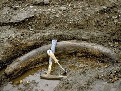 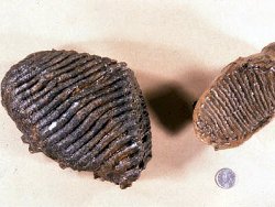 f) This is the only site known in Northern Ireland where bedrock shows evidence of intensive glaciotectonic deformation. g) The range of dates from the site provide a framework for Late Midlandian events in Ireland. A major result is the recognition of ice sheet growth early in the last cold stage and extension of the growing idea of rapid environmental change within this period. h) The palaeobotanical record is unique in Ireland and provides a yardstick for comparisons with critical sites such as Chelford in England. i) Arguments surrounding reworking of earlier biological detritus have been highlighted as well as the difficulty in the recognition of non-sequences. j) The site provides the only profile of any length which can provide evidence for large scale resolution of climatic cycles and ice sheet reconstruction from this sector of NW Europe. | |
| Interpretation: | |
Glaciotectonic deformation of the Oligocene lignite beds is associated with ice pressure from the west. Field relations suggest that ice thrusting of the lignite ridge and till intrusions into lignite beds occurred during the ice movement which deposited the lower till (Unit 2). Shears and smudge structures in the latter are indicative of basal ice deposition. The erratic suite is derived from centres of ice dispersion in Central Tyrone. Units 3 and 4 are interpreted as bottomsets deposited in a proglacial lake when the ice withdrew. Cold periglacial conditions are indicated by the presence of an ice- wedge pseudomorph. Overlying gravels and diamicts (Unit 5) reflect shallowing and a deltaic setting dominated by mass flow. The arctic flora suggests a severe climate when Mammuthus primigenius lived locally. Their scattered remains are also suggestive of freighting by mass flow in a deltaic setting rather than rolling along a stream bed. The woody detritus peat (Unit 6) represents an interstadial period that was warm enough for a sufficiently long period to allow migration of tree species eliminated by earlier cold conditions. Variable rounding and abraided woody fragments and many unabraided fragments suggest both water transport and simple flushing of debris into a shallow deltaic environment. Insect, pollen and macroscopic plant remains present an ecologically consistent picture of Betula-Pinus-Picea woodland, swamp and some adjacent poorly-vegetated zones. The climate was cool temperate with a mean July temperature of 15°C to 18°C and a mean January temperature of -11°C to +4°C. This episode is older than about 48ka B.P. Overlying pebbly sands, gravels and diamicts (Unit 7) are unfossiliferous and represent increased sediment input of coarser poorly-sorted detritus possibly representing climatic deterioration. The overlying organic mud (Unit 8) contains insects and pollen indicative of a cold, treeless environment. Unfossiliferous sands of Unit 8 are well-sorted and are possibly a result of unchannelised floods towards the margins of a sandur plain. The latter probably occurred immediately before deposition of the upper till which was deposited during part of the Late Midlandian glaciation. However it is known from other exposures that interstadial-type conditions returned prior to the advance of Late Midlandian ice (McCabe, 1987). | |
| Conclusions: | |
Aghnadarragh is a classic site for Late Midlandian stratigraphy and climatic variability during the last glacial cycle. Its importance cannot be underestimated internationally. The basal sequence represents early development of ice and subsequence decay. The mammoths flourished at this time. The Aghnadarragh interstadial followed during a phase of climatic warming. Cool and cold phases represent climatic deterioration prior to the growth of the late Midlandian ice sheet. | |
| Notes: | |
The Aghnadarragh site was discovered when the overburden was stripped and a large pit excavated to obtain samples of lignite for commercial evaluation. At present the exposures are degrading due to slope wash and slumping towards the centre of the pit. Water levels in the pit are rising and will in the future be controlled by local water tables and the transmissibility of the till plain. At present only units 8, 9 and 10 are exposed. It is likely that these deposits extend below the flat terrace form along the eastern shore of Lough Neagh. Borehole and seismic profiles suggest that the stratigraphy may be more complete in adjacent areas around the basin. | |
| Keywords | |
|---|---|
| Fossil Groups: | Plant, Vertebrates |
| Fossil List: | Mammuthus primigenius |
| Relations: | Glaciotectonic, Interstadial |
| Geomorph: | till |
| Measurements | |||||
|---|---|---|---|---|---|
| Length: | 290 m | Width: | Height: | 17 m | |
| Depth: | Area: | ||||
| Access | |
|---|---|
| Approach: | 2.5km W of Glenavy. |
| Restrictions: | Access is with owner's prior permission only. |
| Management: | |
a) The site is of high scientific interest and the pit owners allow access if prior permission is obtained. However they regard the site as a potential commercial operation and probably would strongly contest imposition of conservation issues. On the other hand if commercial operations for lignite extraction are to follow new exposures would result and possibly 'fill in' some of the non-sequences documented earlier. b) The pit now contains a deep lake whose western margins are prone to rotational slippage/slumping. Care is therefore needed during geological sampling. c) All pit faces are degrading rapidly. The top of the central ridge of glacitectonised lignite, the upper till (Unit 10) and sands (Unit 9) are well preserved. The most important stratigraphic elements (1-8) are below lake level. d) Measures to enhance the site's value would require a major investment possibly involving purchase of the site, lowering lake levels by continuous pumping and a large-scale development of the site for educational purposes. However if commercial exploitation develops it may be possible for the owners to leave the critical pit faces exposed. If this could be achieved it would be relatively easy to clean the exposures periodically. Notifiable operations include: 1: Modification of the land surface, subsurface, water levels and water courses. 2: Engineering works. 3: Drainage works. 4: Storage/dumping. 5: Field drainage. 6: Utilisation of the artificial lake. 7: Recreational development. 8: Future extraction of lignite. 9: Afforestation or tree planting. 10: Removal of geological specimens. 11: Dumping, discharge/storage of debris. | |
| Threats: | Further flooding and slumping of pit margins, and therefore, critical exposures. |
| Uses | |
| Uses: | The site is fenced off, the western pit slopes are unstable and most of the surrounding land is used for grazing and silage. |
| Potential: | Commercial exploitation of lignite. |
| References (4) | |||
|---|---|---|---|
| McCabe, A.M., 1987. Quaternary deposits and glacial stratigraphy in Ireland. Quaternary Science Reviews, vol. 6, pp.259-299. | |||
| McCabe, A.M., Coope, R.G., Gennard, D.E. & Doughty, P., 1987. Freshwater organic deposits and stratified sediments between early and late Midlandian (Devensian) till sheets at Aghnadarragh, County Antrim, Northern Ireland. Journal of Quaternary Science, vol. 2, pp.11-33. | |||
| Watts, W.A., 1970. Tertiary and interglacial floras in Ireland. In Irish Geographical Studies in Honour of E. Estyn Evans., pp.17-33 Queens University of Belfast. | |||
| Wilson, H.E., 1972. Regional Geology of Northern Ireland. HMSO, Belfast. | |||
| Map(s): | See the 1:50,000 O.S. Sheet 14 (Lough Neagh). | ||
| Record type: | Environment Serv. GIS, ESCR report, J. Preston l | ||
| Entered by: | Crowther, P.R. | ||
| Last updated: | 3 Jul 2006 | ||
| Enlander, I., Dempster, M. & Doughty, P., 2026. Aghnadarragh, County Antrim, site details. [In] Earth Science Conservation Review. https://www.habitas.org.uk/escr/site.php?item=1. Accessed on 2026-11-03. |
| Previous Site | Next Site |