
| Previous Site | Next Site |
Earth Science Conservation Review
| Slieve Gullion Ring - Cam Lough Quarry | Armagh |
| Site number: | 1119 | ||
| ESCC: | ED | ||
| Locality Type: | Quarry (disused) | Status: | ASSI |
| Grid Reference: | J037246 Centroid | ||
| Google maps: | 54.16042,-6.41249 | ||
| County: | Armagh | Council area: | Newry, Mourne & Down District Council |
| Period: | Tertiary, Devonian, Silurian | ||
| Stages: | Devonian Undifferentiated, Palaeogene, Silurian Undifferentiated | ||
| Lithostrat: | Lislea Granophyre, Newry Granodiorite, Slieve Gullion Complex | ||
| Site Description | |
|---|---|
 | |
| Description: | |
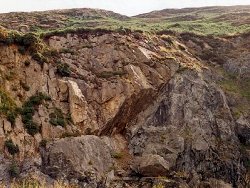
Silurian shales and grits veined locally by the Caledonian granodiorite of Newry and traversed by mineralised fault breccia have been exploited for road metal. Along the N face of the quarry the steep outward dipping inner contact (the footwall) of the Porphyritic Granophyre ring-dyke has been uncovered. The inner margin of the ring-dyke is traversed by numerous mylonitic crush veins. Isolated exposures occur further north on the heath covered lower slopes of Camlough Mountain and offer a traverse across the ring-dyke to its outer contact with the Newry Granodiorite. | |
| Importance: | |
A fine exposure of the inner wall of a ring-dyke, and ideal as a demonstration of the local geological structure. The overhanging quarry face should ensure the section remains free of scree and vegetation. | |
| Notes: | |
For reference list see; Key Site 1118 - Slieve Gullion Ring - Overview | |
| Keywords | |
|---|---|
| Rocks: | Granodiorite, Granophyre, Shale |
| Structures: | ring-dyke |
| Relations: | Footwall, Intrusion |
| Access | |
|---|---|
| Approach: | The quarry lies just E of the road between Camlough Village and Meigh, 2.5 km S of Camlough. The Quarry overlooks Cam Lough itself. |
| Map(s): | For site location see the 1:50,000 O.S. Sheet 29 (The Mournes) Discoverer Series. | ||
| Record type: | ESCR report | ||
| Entered by: | E M Porter | ||
| Enlander, I., Dempster, M. & Doughty, P., 2026. Slieve Gullion Ring - Cam Lough Quarry, County Armagh, site details. [In] Earth Science Conservation Review. https://www.habitas.org.uk/escr/site.php?item=1119. Accessed on 2026-11-08. |
| Previous Site | Next Site |