
| Previous Site | Next Site |
Earth Science Conservation Review
| Slieve Gullion Ring - Sarah Daly's Bridge | Armagh |
| Site number: | 1127 | ||
| ESCC: | EO | ||
| Locality Type: | Crag | Status: | ASSI |
| Grid Reference: | J02772308 Centroid | ||
| Google maps: | 54.14625,-6.42833 | ||
| County: | Armagh | Council area: | Newry, Mourne & Down District Council |
| Period: | Tertiary | ||
| Stages: | Palaeogene | ||
| Lithostrat: | Slieve Gullion Complex | ||
| Site Description | |
|---|---|
 | |
| Description: | |
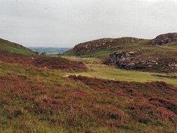
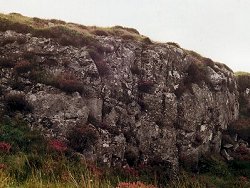
The lobate and crenulate contact between dolerite of layer 4 above and granophyre below can be traced along the length of the crag.
 | |
| Importance: | |
This locality is illustrated by Elwell et al (1974) in their classification of net-veining. A good example of a liquid/liquid contact. It overlooks bogland of botanical interest. | |
| Notes: | |
For reference list see; Key Site 1118 - Slieve Gullion Ring - Overview Although details of the contact are obscured by weathering and lichen growth, it can be identified and traced by close inspection. | |
| Keywords | |
|---|---|
| Rocks: | Dolerite, Granophyre |
| Structures: | net veins |
| Relations: | Contact, Intrusion |
| NonGeol: | Surrounding bogland is of botanical interest. |
| Access | |
|---|---|
| Approach: | The exposure is located just N of the scenic road from Sarah Daly's Bridge to Ballintemple, approximately 2.5 km E of Sarah Daly's Bridge, J00552260. |
| Map(s): | For site location see the 1:50,000 O.S. Sheet 29 (The Mournes) Discoverer Series. | ||
| Record type: | ESCR report | ||
| Entered by: | E M Porter | ||
| Enlander, I., Dempster, M. & Doughty, P., 2026. Slieve Gullion Ring - Sarah Daly's Bridge, County Armagh, site details. [In] Earth Science Conservation Review. https://www.habitas.org.uk/escr/site.php?item=1127. Accessed on 2026-11-08. |
| Previous Site | Next Site |