
| Previous Site | Next Site |
Earth Science Conservation Review
| Mullynaskeagh Clay Pit | Fermanagh |
| Site number: | 116 | ||
| ESCC: | ED | ||
| Locality Type: | Pit | Status: | ASSI |
| Grid Reference: | H069531 Centroid | ||
| Google maps: | 54.42687,-7.89367 | ||
| County: | Fermanagh | Council area: | Fermanagh & Omagh District Council |
| Period: | Carboniferous | ||
| Stages: | Brigantian | ||
| Lithostrat: | Bellavally Formation, Leitrim Group, Sheena Shale Member | ||
| Site Description | |
|---|---|
 | |
| Highlights: | |
Mullynaskeagh Clay Pit exposes the thickest development of the Sheena Shale Member of the Lower Carboniferous Leitrim Group. It is unusually fossiliferous, with a particular abundance and diversity of well-preserved goniatites. | |
| Introduction: | |
Mullynaskeagh Clay Pit lies within what has been termed the Doagh outlier, west of Derrygonnelly, Co. Fermanagh. It is situated adjacent to a Forestry track just to the north of the point where it crosses a minor stream, at grid ref. 23/069531. The pit has been excavated into a thick shale unit of Brigantian age within the Lower Carboniferous Leitrim Group, which extends across north-east Connaught. The site has been mentioned briefly by Brandon (1972) and by Brandon and Hodson (1984) as well as in two unpublished accounts by Tom Mason (Mason 1971, 1974). | |
| Description: | |
The Doagh outlier comprises a downfaulted block of late Visean and Namurian clastic-dominated sediments, together termed the Leitrim Group, preserved within an area of older Visean clastics. Exposure of the downfaulted clastics is poor on account of the prevalence in this part of the succession of easily weathered mudstones, the presence of a variable thickness of glacial drift, and the widespread planting of conifers over a substantial area of the outlier. The geology of the region has been reconstructed largely from exposures along incised streams together with a few small quarries and occasional small crags of the harder lithologies. Brandon (1972) was able to reconstruct an almost complete succession of the Leitrim Group from the upper part of the Dartry Limestone Group beneath, a total thickness of more than 150 metres. The Mullynaskeagh clay pit exposes one of the clearest sections through any part of the Leitrim Group in this area. The lowest unit of the Leitrim Group, the Glenade Sandstone Member, lies at shallow depth below the floor of the quarry. Near the quarry Brandon (1972) showed a transition from flaggy sandstone upwards into brown micaceous shale within 0.61 metres, although in the stream section just upstream of the quarry grey calcareous shale was seen to lie directly above the sandstone. About 18.3 metres of shales are exposed in the quarry, dipping gently to the south, and they have been assigned to the Sheena Shale Member of the Bellavally Formation. The Bellavally Formation was regarded as late Asbian in age by Brandon and Hodson (1984) but the presence of Goniatites falcatus in the Sheena Shale Member demonstrates an early Brigantian age, P1b Zone, for at least part of the member. The contact of the Sheena Shales Member with the overlying Corry Member appears not to be exposed in the quarry or elsewhere in the outlier. The shales in the quarry are rather weathered but typically are grey to dark blue-grey in colour. There are numerous thin nodular limestones and small calcareous nodules within the shales, while a more persistant ochreous-weathering limestone some 0.13 metres thick is developed about 10.36 metres above the base. Thin laminated carbonate (limestone or dolomite) bands are present low in the Sheena Shale Member in several stream exposures nearby but have not been seen in the quarry itself. The shales generally are fossiliferous, with the fossils generally uncrushed and often pyritised. Mason (1971) stated that most of the fauna that he recovered came from above the ochreous-weathering limestone. The limestone itself was described as unfossiliferous and underlain by a coaly shale. Brandon (1972) listed a diverse fauna from the Sheena Shale Member, with most material being obtained from the quarry. Additional species listed by Mason (1974) are marked in the following list by an asterisk. A still more comprehensive faunal list for the Sheena Shale is provided by Brandon and Hodson (1984; Table 1) based on material from sites south of the border although many of these species are known, or may be anticipated, to occur at Mullynaskeagh. Mason (1971) found gastropods and the bivalves Nucula and Nuculopsis to occur in some abundance while corals and brachipods were small, uncommon and restricted in their distribution. At that time, soon after the original excavation of the quarry, the goniatites were well-preserved as pyritic internal moulds, often encased in nodules and occasionally with the original shell material preserved. However, subsequent weathering, which the shales have experienced at this site, has adversely affected the preservation of many of these pyritised fossils. ANTHOZOA Zaphrentid corals BRACHIOPODA Chonetes hardrensis, Dictyoclostus sp., Lingula sp.*, Martinia aff. glabra, Orbiculoidea sp., Productus sp.*, Spirifer sp. GASTROPODA Bellerophon sp.*, Bucanopsis hibernicus, Euomphalus sp., Euphemites sp., Glabrocingulum sp., Soleniscus intermedia, Soleniscus turgida, Gastropod indet. (highly spired form) BIVALVIA Arca sp.*, Nucula sp.*, ?Nuculopsis ventricosa, ?Palaeoneilo laevirostris, Posidonia becheri, 'Pseudamusium' ? sp. CEPHALOPODA Brachycycloceras sp., coiled nautiloids indet., Girtyoceras sp., Goniatites concentricus, Goniatites falcatus, Goniatites spirifer, Goniatites striatus, Goniatites cf. warslowensis, Goniatites sp. (not striatus group), Muensteroceras crassum, Muensteroceras (Beyrichoceratoides) sp., Nomismoceras vittiger*, Orthoceras sp.*, Rineceras sp.*, Vestinautilus sp. ARTHROPODA Ostracods indet. | |
| Importance: | |
The site's importance centres on the rich and diverse fauna, particularly of cephalopods, which has been obtained from a mudstone unit, the Sheena Shale, which otherwise is only poorly exposed in stream sections. Furthermore, the site would appear to expose a uniquely thick development of these shales by comparison with other exposures on Cuilcagh Mountain. Mullynaskeagh Clay Pit has considerable advantages over the Cuilcagh Mountain sites in its accessibility. Lying on Forest Service land and adjacent to a Forestry track it offers considerable scope for development as a public resource. The position of the site would allow access by heavy machinery to clean up the exposure periodically, removing the vegetation cover, largely of brambles, and creating spoil heaps from which the public could collect fossils. This would ensure that the site remains accessible for scientific investigations whilst providing an opportunity for the public to gain a greater understanding of their geological heritage. | |
| Interpretation: | |
Comments on the palaeoenvironment of the Sheena Shale and the palaeoecology of its contained fauna have been made in two unpublished accounts by Mason (1971, 1974), with more general comments on depositional setting by Brandon (1972) and Brandon and Hodson (1984). In his earlier account, Mason (1971) considered the Sheena Shale [=Mullynaskeagh Shale of his account] to have been deposited on top of a drowned delta represented by the underlying Glenade Sandstone [=Shean Sandstone of his account]. He considered the black pyritic mudstones with thin-shelled pectinacean bivalves to indicate quiet basinal conditions, with a water depth probably greater than 100 metres. On a broader, regional scale Brandon (1972) noted a lateral facies and faunal change between the Connaught Coalfield and the Dungannon area to the north-east. The sequence in the Doagh outlier, lying roughly midway between these two areas, therefore shows transitional facies and fauna from basinal mudstones ('Bowland Shale' facies) to shallower shelf sediments ('Yoredale' facies). The composition of the fauna of the Sheena Shale at Mullynaskeagh, with abundant nektonic cephalopods and a benthic fauna dominated by small gastropods and thin-shelled bivalves, such as Nucula and Nuculopsis, suggests rather poorly aerobic conditions on the sea floor. Mason's comment that corals and brachiopods at this site are small and restricted to particular horizons lends further support to this scenario. It suggests that only occasionally did the sea floor become sufficiently well-oxygenated for stenotopic organisms such as corals and brachiopods to become established. Preservation of the original aragonitic shell and the pyritic internal moulds of the goniatites also indicate a poorly oxygenated to dysaerobic benthic environment. Deposit feeders dominate the fauna, in contrast to carbonate facies where the filter-feeding lophophorates and coelenterates are dominant, suggesting a relatively high rate of sediment accumulation. Mason (1974) comments that even the smallest specimens were preserved in exquisite detail, indicating negligible post-mortem transport. | |
| Conclusions: | |
Mullynaskeagh Clay Pit provides an exceptionally clear and accessible exposure of the Sheena Shale Member, a particularly fossiliferous unit within the Lower Carboniferous (Brigantian) Leitrim Group. Its rich and diverse fossil assemblage, particularly of goniatites, is unmatched by any other site of similar age in Northern Ireland. | |
| Notes: | |
For general information and references on the Palaeontology of Northern Ireland see Key Site 109 - Palaeontological sites of N. Ireland - Introduction For other site specific information and references on the Palaeontology of Northern Ireland see Key Site 110 - Ballycastle Pellet Chalk, Key Site 111 - Ballypalady Plant Bed, Key Site 112 - Carrick Lough, Bunnahone Lough and the Sillees River, Key Site 113 - Faragandoo, Key Site 114 - Minnis North Mudflow, Key Site 115 - Moyola River, Key Site 117 - Murlough Bay, Key Site 118 - Portnaloub, Key Site 119 - Sillees River, Glenasheevar, Key Site 120 - Tircrevan Burn, and Key Site 121 - Tullyconnell. | |
| Keywords | |
|---|---|
| Minerals: | Pyrite |
| Rocks: | Limestone, Shale |
| Fossil Groups: | Ammonite, Arthropod, Bivalve, Brachiopod, Coral, Gastropod, Goniatite, Nautiloid |
| Relations: | Marine sediments |
| Measurements | |||||
|---|---|---|---|---|---|
| Length: | Width: | Height: | ~18.3m | ||
| Depth: | Area: | ||||
| Access | |
|---|---|
| Approach: | By forestry track. |
| Management: | |
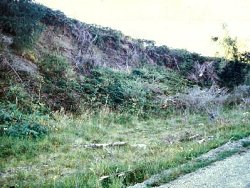
In its present condition, heavily overgrown by brambles and herbaceous shrubs, little can be seen of the succession as originally described and it is of limited value to either the scientific community or the public at large. The Forestry track would allow easy access to the site by heavy machinery which could, periodically, remove this vegetation cover and clean the exposed face. The spoil heaps created during this process could provide a valuable public resource as a 'fossil collecting site'. Although the site is located within an extensive area of Forestry plantation, this does not appear to pose any immediate threat. However, there has been recent clear-felling in this area and the importance of site should be considered in any planned replanting programme. | |
| Uses | |
| Uses: | At present the site forms a rather overgrown area adjacent to a Forestry track. The area of forestry around it has been partly cleared. |
| References (4) | |||
|---|---|---|---|
| Brandon, A., 1972. The upper Visean and Namurian shales of the Doagh Outlier, County Fermanagh, Northern Ireland. Irish Naturalists Journal, vol. 17, pp.159-170. | |||
| Brandon, A. & Hodson, F., 1984. Stratigraphy and Palaeontology of the late Visean and early Namurian rocks of north-east Connaught. Special Papers of the Geological Survey of Ireland, numb. 6. | |||
| Mason, T.R., 1971. The Visean rocks of a part of north-west Co. Fermanagh (Thesis) BSc thesis, Queen's University, Belfast. | |||
| Mason, T.R., 1974. The geology of the northern part of the Fermanagh highlands with special reference to the palaeoenvironment (Thesis) PhD thesis, Queen's University, Belfast. | |||
| Record type: | ESCR report | Recorded by: | Michael J. Simms, Department of Geology, Ulster Mu |
| Entered by: | E M Porter | ||
| Enlander, I., Dempster, M. & Doughty, P., 2026. Mullynaskeagh Clay Pit, County Fermanagh, site details. [In] Earth Science Conservation Review. https://www.habitas.org.uk/escr/site.php?item=116. Accessed on 2026-11-06. |
| Previous Site | Next Site |