
| Previous Site | Next Site |
Earth Science Conservation Review
| Garron Point-Cloghastucan | Antrim |
| Site number: | 1212 | ||
| ESCC: | EC | ||
| Locality Type: | Coastal section | Status: | ASSI |
| Grid Reference: | D290251,D305234 End(s) of linear site, Not Entered | ||
| Google maps: | 55.05694,-5.98123 | ||
| County: | Antrim | Council area: | Causeway Coast & Glens Borough Council |
| Period: | Cretaceous | ||
| Stages: | Campanian, Santonian | ||
| Lithostrat: | Ballintoy Chalk Member, Galboly Chalk Member, Garron Chalk Member, Glenarm Chalk Member, Portrush Chalk Member, Ulster White Limestone Formation | ||
| Site Description | |
|---|---|
 | |
| Highlights: | |
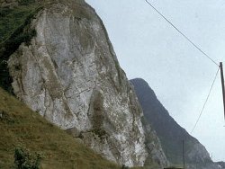
The sites include excellent exposures of the Ulster White Limestone Formation. They include the type sections for the Galboly Chalk and Garron Chalk members and can be used as examples of chalk sedimentation in the Larne-Lough Neagh Basin. | |
| Introduction: | |
These sites lie on the east coast of Co. Antrim between Carnlough and Cushendall. The area has been subjected to extensive landslipping, a fact noted by Hume (1897) and many of the outcrops are on tilted blocks. There is little exposure apart from the Ulster White Limestone and the overlying Palaeogene basalts. The area was mapped and an explanatory memoir produced by Symes and McHenry (1886). More recent studies were by Fletcher (1977). | |
| Description: | |
In these slipped blocks all of the members of the Ulster White Limestone Formation from the Galboly Chalk Member to the Portrush Chalk Member are developed but this description is limited to the Galboly Chalk and Garron Chalk members. The type section for the Galboly Chalk Member is the roadside pillar north of Cloghastucan (Site b). 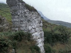 Inoceramus prismatic fragments are abundant and slender rather fragile specimens of Actinocamax verus are the only belemnites recorded. Occasional ossicles of Uintacrinus and Bourgueticrinus can be found, but the commonest zonal indicators are shape variants of Echinocorys. The Garron Chalk Member, which conformably overlies the Glenarm Chalk Member, is named from the type section in the cliff section just north of the Post Office at Garron Point (Site c). Garron Chalk sediment has a high content of fragmental Inoceramus shell. Large fragments, seen in section as prismatic sheets 0.23-0.7m long, are particularly distinctive at the level of the upper massive flint bands of Bed C. The Garron Chalk Member can be subdivided into three beds of large flints: Bed A, 2.34m thick, has massive purple-tinged flints terminating with a bedding plane below the tabular flints at the base of Bed B. Bed B, 3.76m thick, is characterised by a middle belt of very irregularly distributed giant flints separated from the basal tabular belt by a prominent flintless zone. The top of this bed is characterised by small nodular flints and is likewise separated from the massive flints by a much narrower flintless zone. Bed C, 3.55m thick, has a belt of giant flints succeeded by a thin belt of wavy-bedded sediment with small nodular flints immediately underlying the terminal bedding plane. | |
| Importance: | |
These sites provide the type localities for the Galboly Chalk and Garron Chalk members which are well exposed in cliff and foreshore exposures. They enable the relative influence of basins and more positive areas on chalk sedimentation to be determined. They are of national significance and should be conserved. | |
| Interpretation: | |
Correlation of the Galboly Chalk Member demonstrates that the earliest limestone development in the Rathlin Basin and the Larne-Lough Neagh Basin is almost contemporaneous (Reid, 1964). The presence of green pebble horizons in those sections where the characteristic flint bands are absent, provides the evidence for sedimentary breaks causing a reduction in the thickness of the member. By reference to the type section, the relative amount of non-sequence can be determined for any locality and an areal pattern can be determined that reflects the tectonic controls on Cretaceous sedimentation. Thickest development of the member was in the Rathlin Basin and the Larne-Lough Neagh Basin, north and south of the Dalradian ridge, which together with the other more positive blocks, the Londonderry Shelf and the Lagan Valley was covered by shallow water. Surface disturbances were probably of such amplitude to prevent the settlement of sediment. Depth of water was therefore a major control over deposition. Conditions within the basins varied considerably and minor areas of relative uplift produced attenuation and consequent lensing of strata. Within the Larne-Lough Neagh Basin, two distinct positive elements, the Carnlough and Larne axes delimit three areas of thicker sediment. The subsidiary basin between the Dalradian ridge and the Carnlough Axis, including these sites, show the thickest development of the Ulster White Limestone of the Uintacrinus socialis Zone. Between Garron Point and Ballygalley there is a marked reduction over the same structure which was effective during the pre- Cretaceous period of erosion. The increased thickness within this central sag reached its maximum around Killyglen before a further reduction southwards. Through the Waterloo sections to Glenoe the sequence thins appreciably and is unrepresented at Magheramorne. In the Rathlin Basin the Galboly Chalk Member is well represented between Murlough Bay and White Park Bay but it is overstepped on the Londonderry Shelf. In the Rathlin Basin Bed A of the Garron Chalk Member is relatively reduced, in some way perhaps connected with the influence which gave rise to the North Antrim Hardgrounds. The Garron Chalk Member may be more thickly developed to the north of the Dalradian ridge. This might suggest that there was a distinct adjustment of basement controls on sedimentation and that the Larne-Lough Neagh Basin, with its much thicker pre-Garron Chalk succession, became more stable. Hence the Rathlin Basin received a proportionally greater amount of sediment; this downwarp differential appears to have been maintained into the Palaeogene, as may be gauged by the relative amounts of preserved post-Garron Chalk. | |
| Conclusions: | |
Between Garron Point and Cloghastucan the type localities for the Santonian Galboly Chalk Member and the Campanian Garron Chalk Member are found. The Dalradian ridge to the north, and the minor axes within the basin, can be shown to have major effects on chalk sedimentation in the area and the sites should be conserved. | |
| Notes: | |
For general information on the Cretaceous System in N. Ireland see Key Site 1194 - The Cretaceous System in N. Ireland - Introduction. For information on other Cretaceous sites see Key Site 1207 - White Rocks - Cretaceous, Key Site 1208 - White Park Bay, Key Site 1209 - Dunnaglea-Larry Bane Bay, Key Site 1210 - Port Calliagh-Ballycastle, Key Site 1211 - Capecastle Quarry, Key Site 1213 - Glenarm Quarry, Key Site 1214 - Creggan Quarry, Key Site 1215 - Portmuck, Island Magee, Key Site 1216 - White Head, Key Site 1217 - Clarehill Quarry, Key Site 1218 - Kilcoan, Island Magee. | |
| Keywords | |
|---|---|
| Rocks: | Flint, Limestone |
| Fossil Groups: | Belemnite, Coral, Polyzoan |
| Fossil List: | Actinocamax verus , Inoceramus sp. |
| Relations: | Marine sediments |
| Access | |
|---|---|
| Approach: | The east coast of Co. Antrim between Carnlough and Cushendall. Access to the Garron Point site is from the car park to the south of the Post Office while the pillar near Cloghastucan can be accessed from the main road. |
| Management: | |
The area is still subject to landslipping which could result in the destruction of part of the outcrop. To the north of the pillar, which could be removed by road widening or simply fall down, there are alternative foreshore exposures of the Galboly Chalk Member which could be used as an alternative type section. | |
| Threats: | Further landslipping |
| References (4) | |||
|---|---|---|---|
| Fletcher, T.P., 1977. Lithostratigraphy of the Chalk (Ulster White Limestone Formation) in Northern Ireland. Report of the Institute of Geological Sciences, vol. 77/14. | |||
| Hume, W.F., 1897. The Cretaceous strata of County Antrim. Quarterly Journal of the Geological Society of London, vol. 53, pp.540-606. | |||
| Reid, R.E.H., 1964. The Lower (pre-Belemnitella mucronata) White Limestone of the east and north-east of County Antrim. Irish Naturalists Journal, vol. 17, pp.105-129. | |||
| Symes, R.G & McHenry, A., 1886. Explanatory memoir to accompany sheet 14. Memoirs of the Geological Survey of Ireland. | |||
| Record type: | ESCR report | ||
| Entered by: | E M Porter | ||
| Last updated: | 6 Jun 2005 | ||
| Enlander, I., Dempster, M. & Doughty, P., 2026. Garron Point-Cloghastucan, County Antrim, site details. [In] Earth Science Conservation Review. https://www.habitas.org.uk/escr/site.php?item=1212. Accessed on 2026-11-06. |
| Previous Site | Next Site |