
| Previous Site | Next Site |
Earth Science Conservation Review
| Gadalough | Fermanagh |
| Site number: | 126 | ||
| ESCC: | EO | ||
| Locality Type: | Inland exposure, Roadside section | Status: | ESCR |
| Grid Reference: | G983603 Centroid | ||
| Google maps: | 54.49159,-8.02621 | ||
| County: | Fermanagh | Council area: | Fermanagh & Omagh District Council |
| Period: | Precambrian | ||
| Stages: | Moinian | ||
| Lithostrat: | Lough Derg Group, Slishwood Division | ||
| Site Description | |
|---|---|
 | |
| Highlights: | |
The site contains unusual altered and serpentinized relics of basic or ultrabasic? igneous intruded within the Lough Derg Group (Slishwood Division) prior to deformation and metamorphism. | |
| Introduction: | |
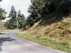
This site is located in Gadalough Townland, 300m west of Lough Scalban and 4.5km east-north-east of Belleek, Co Fermanagh. Outcrops occur at the roadside and in a series of partially overgrown rocky knolls in an adjoining field. Gadalough is situated close to the southern edge of the Lough Derg Inlier. Throughout this and the surrounding area the rocks are predominantly coarse-grained, granulitic, siliceous psammites which form part of the Lough Derg Group. On the first edition of the one inch to one mile Geological Map of the area (Sheet 32, Pettigoe, Geological Survey of Ireland, 1885) the rocks of the Lough Derg Inlier were referred to jointly as "gneiss & schist". No basic igneous intrusions are shown on the map, although in the accompanying memoir (Symes, 1891) reference was made to several specimens of epidiorite and amphibolite. Geikie (1891) was first to indicate that the Lough Derg rocks could be "readily separated from the ordinary metamorphic rocks (Dalradian) of Donegal". Geikie assigned an Archaean age to the Inlier and both he and Symes drew attention to similarities with the "the more ancient gneisses (Lewisian) of the Scottish Highlands". Anderson (1948) published the first detailed account of the stratigraphy, structure and metamorphism of the Lough Derg Inlier. He was also first to suggest a Moinian age for the "Lough Derg Psammite Group" and the epidiorites included therein. Anderson's account also included a detailed discussion of the petrology and development of the epidiorite and amphibolites (metabasites) within the Lough Derg Group. Max & Long (1984) produced a Rb-Sr whole rock isochron indicating an 895+/-60Ma (Grenvillian?) age for the Lough Derg Inlier. They also pointed to similarities between the Lough Derg Inlier and rocks at Rosses Point and the Ox Mountains in the Republic of Ireland, and introduced the concept of the Slishwood Division to encompass this pre-Dalradian basement. The most recently published maps which cover this site include a second 1:50,000 scale edition of Sheet 32 (Kesh, Geological Survey of Northern Ireland, 1994) and the 1:250,000 scale Solid Geology Map of Northern Ireland (Geological Survey of Northern Ireland, 1997). Both maps show the location of the major metabasite bodies on the Northern Ireland side of the border. | |
| Description: | |
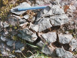
In the partially overgrown roadside outcrop, and in overgrown crags in the field directly to the east, are several occurrences of deeply altered dark green to grey and in parts ocherous rocks forming a serpentinitised basic body estimated to be up to 50m wide. The rocks are deeply weathered and have undergone a pervasive alteration process with locally extensive net veining (magnesite?) with formation of dark green and black serpentine minerals. Detailed petrological and XRD work are required to unravel the detailed paragenesis of these rocks. | |
| Importance: | |
The Gadalough site is of national importance offering access to rare examples of extensive "serpentinitic" alteration of basic or ultrabasic intrusions
 | |
| Interpretation: | |
The rocks at Gadalough originated as basic or possibly mantle derived ultrabasic igneous intrusions emplaced within the predominantly quartz and feldspar rich sediments which form the bulk of the Lough Derg Group. Max & Long (1985) have indicated that these rocks formed 895+/-60Ma (Grenvillian?) and are part of the Pre-Dalradian basement in NW Ireland. The Lough Derg Group was subjected to a series of deformations and metamorphic events during the Grenvillian? and early-Caledonian (Grampian) Orogenies. Grenvillian events resulted in high-temperature, high-pressure Granulite Facies metamorphism. Subsequently, during the early-Caledonian, a low-temperature and low-pressure (Amphibolite Facies) metamorphism overprinted the earlier, Granulite Facies mineral assemblages. This later event was accompanied by the deformation which Anderson (1948) has indicated formed most of the folds in the Lough Derg Inlier, including the Lough Derg Anticline. | |
| Conclusions: | |
Gadalough is a comparatively rare site in the Lough Derg Inlier which warrants further study and may provide some insight to basic magmatism in the Moinian and the subsequent extreme alteration of mafic and ultramafic rocks in the area. | |
| Notes: | |
For information and references on other sites within the Pre-Dalradian Lough Derg Inlier see the following sites: Key Site 125 - Croagh Mountain Key Site 127 - Larkhill For information and references on sites within the Pre-Dalradian Central Tyrone Inlier see the following sites: Key Site 128 - Oughtmore Mountain Key Site 129 - Eagles Rock For general information on the Pre-Dalradian rocks of Northern Ireland see the following site: Key Site 123 - The Pre-Dalradian Rocks of Northern Ireland For information on the Dalradian rocks of Northern Ireland see the following site: Key Site 124 - The Dalradian Rocks of Northern Ireland For general information and an extensive reference list on the Precambrian of Northern Ireland see the following site: Key Site 122 - An Introduction to the Precambrian of Northern Ireland | |
| Keywords | |
|---|---|
| Rocks: | Serpentinite |
| Access | |
|---|---|
| Management: | |
Although part of this site is accessible on the roadside, most lies within fenced pastureland. Care should be taken to ensure that those accessing these fields do so in a manner that does not disturb the livestock. This site consists of several rather small outcrops spread over a relatively small area. The roadside outcrop is already almost completely overgrown and will soon be completely obscured. The outcrops within the fields are also partially overgrown and will require careful management. Because outcrop is limited, it would be wise to consider imposing restrictions on hammering and sampling at the site. | |
| Uses | |
| Uses: | Pastureland |
| References (5) | |||
|---|---|---|---|
| Anderson, J.G.C., 1948. The occurrence of Moinian rocks in Ireland Quarterly Journal of the Geological Society of London, vol. 103, pp.171-. | |||
| Geikie, A., 1891. Anniversary Address to the President Quarterly Journal of the Geological Society of London, vol. 47, pp.63-. | |||
| Max, M.D. & Long, C.B., 1985. Pre-Caledonian basement in Ireland and its cover relationships Geological Journal, vol. 20, pp.341-366. | |||
| Max, M.D., O'Connor, P.J. & Long, C.B., 1984. New age data from the Pre-Caledonian basement of the NE Ox Mountains and Lough Derg Inliers, Ireland Bulletin of the Geological Survey of Ireland, vol. 3, pp.203-209. | |||
| Symes, R.G., 1891. Explanatory memoir to accompany Sheets 31 (in part) and 32 of the maps of the Geological Survey of Ireland HMSO, Dublin. | |||
| Map(s): | GSI (1885). 1:63,360 Geological Sheet 32 (Pettigoe), Dublin OS for GSI GSNI (1994). Kesh, Northern Ireland, Sheet 32, Solid Geology 1:50,000 (BGS) GSNI (1997). Northern Ireland, Solid Geology (2nd edition) 1:250,000 (BGS) | ||
| Record type: | ESCR report | Recorded by: | T.P. Johnston, GSNI. |
| Entered by: | E M Porter | ||
| Last updated: | 6 Jun 2005 | ||
| Enlander, I., Dempster, M. & Doughty, P., 2026. Gadalough, County Fermanagh, site details. [In] Earth Science Conservation Review. https://www.habitas.org.uk/escr/site.php?item=126. Accessed on 2026-11-06. |
| Previous Site | Next Site |