
| Previous Site | Next Site |
Earth Science Conservation Review
| Mullaghcarbatagh | Tyrone |
| Site number: | 132 | ||
| ESCC: | EO | ||
| Locality Type: | Crag, Crags | Status: | ESCR |
| Grid Reference: | H518949 Centroid | ||
| Google maps: | 54.79973,-7.19455 | ||
| County: | Tyrone | Council area: | Derry City & Strabane District Council |
| Period: | Precambrian | ||
| Stages: | Dalradian | ||
| Lithostrat: | Dart Formation, Glenga Amphibolite Member, Southern Highlands Group | ||
| Site Description | |
|---|---|
 | |
| Highlights: | |
The slopes and peaks of Mullaghcarbatagh Mountain offer ready access to high quality exposures of the Dart Formation. Across this site, it is possible to trace systematic lithological changes in the lowermost stratigraphic levels of the Dart Formation from volcanogenic rocks (Glenga Amphibolite Member) at the base upwards to more typical coarse-grained siliciclastic facies rocks. | |
| Introduction: | |
Mullaghcarbatagh Mountain (517m) [H519 949] is situated at the south-westerly end of the main Sperrin Ridge, about 5km north-east of Plumbridge. Access to the site is by foot across fenced rough pastureland and open moorland and is most readily gained from the Bradkeel Road at the southern end of Butterlope Glen [H495 946]. In addition to Mullaghcarbatagh summit, the site encompasses outcrops on the northern slopes of Mullaghclogher (572m) [H530 950] and Oughtnager [H505 946] north and west of Bradkeel Forest. Portlock (1843) referred collectively to rocks in the region of this site, as "mica and hornblendic schists". On the first edition of the one inch to one mile geological map (Sheet 26, Draperstown) (Geological Survey of Ireland, 1882, Nolan, 1884) these strata are shown undivided and referred to as, "Schist and Gneiss (Lower Silurian metamorphosed)". Hartley (1938) published the first detailed lithostratigraphic map of this part of the Sperrin Mountains and grouped strata at this site within his "Schistose grit division of Dart". Arthurs (1976) redefined the Dart Formation based partly on Hartley's work and paved the way for the definition of the formal stratotypes for the Dart Formation and the Glenga Amphibolite Member. These feature on the most recent geological maps of the area (Geological Survey of Northern Ireland, 1995, 1997), see table below. It should be noted however that this interpretation of the stratigraphy and structure of the southern Sperrin Mountains has recently been challenged by Alsop et al. (1993) who include all of the formations (Dart, Glenelly, Glengawna and Mullaghcarn Formations) in the Southern Sperrins within what they refer to as the "Sperrin Formation. Furthermore Alsop et al. (1994) have suggested that all these formations belong to the Argyll Group (Middle Dalradian). This reinterpretation has been challenged by Arthurs and by Johnston & Smith (Arthurs et al., 1994) and is the subject of ongoing controversy. TABLE TO BE ADDED Dalradian stratigraphy and ESCR sites in the southern Sperrin Mountains. | |
| Description: | |
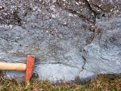
The area adjacent to the Bradkeel Road contains numerous outcrops of pale to mid-green amphibolitic schists (Glenga Amphibolite Member). These are predominantly actinolitic meta-tuffs locally interbedded with more hornblendic and quartzo-feldspathic horizons. These rocks have a silky appearance and a strong characteristic rodded intersection lineation. Stratigraphically, the Glenga Amphibolite Member marks the transition between the Dart Formation and the older Dungiven Formation which structurally overlies the Dart directly to the north-west in Butterlope Glen. Eastwards from the Bradkeel Road outcrop decreases and disappears beneath thick bogland then reappearing at the base of Oughtnager [H506 949] where a few isolated outcrops of fine grained amphibolite schist can be seen. From Oughtnager to the summits of Mullaghcarbatagh and Mullaghclogher and beyond, outcrops are predominantly of quartz and feldspar rich rudaceous and arenaceous lithologies typical of the Dart Formation. At Oughtnager [H506 948], there are several good exposures of thick microconglomerate and quartz grit beds. These beds contain angular and subrounded pebbles of white vein quartz (90%) and pale pinkish cream feldspar within a finer grained quartz feldspar matrix with sparse aligned white mica, biotite and subsidiary chlorite. The pebbles and clasts are stretched and all outcrops in this area have a well developed mineral stretching lineation (017/18NE) and a penetrative cleavage (S2) trending about 045/32NW, broadly parallel to bedding. Locally there is evidence that the succession is inverted and conglomerate beds can be seen to grade downwards into finer lithologies in which smaller pebbles are scattered within a more schistose finer grained matrix. On the western approach to Mullaghcarbatagh summit and in a broad trough directly east of the summit, there are numerous exposures of compact, fine-grained, dark green schist locally with a fine banding of paler, more feldspathic and calcareous schist. These amphibolitic schists 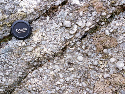 Close to the summit of Mullaghcarbatagh, and along the north-facing slope of the col towards Mullaghclogher, the succession is dominated by white weathering psammites and schistose grit beds interbedded with occasional intercalations (0.2m thick) of slightly silvery grey crenulated graphitic mica and quartz mica schist. All of these beds have a well developed and penetrative spaced cleavage (S2). East of Mullaghcarbatagh [H522 950], graded psammite units have sharp bases overlying fine-grained psammitic schist beds. Younging evidence at this locality indicates that the succession youngs and dips SW whereas further north, across the axis of the synformal fold (F4) in the extrusive amphibolite on Mullaghcarbatagh, the beds young towards the north-west. | |
| Importance: | |
This site is important because it provides locally unsurpassed exposure of the lowermost stratigraphic levels of the Dart Formation. It includes parts of the stratotype areas for the Dart Formation and the type section of the Glenga Amphibolite Member. The site offers an opportunity to study the predominantly coarse-grained quartzo-feldspathic turbidite and amphibolitic green beds lithologies of the Dart Formation. The rocks at this site also contain many important sedimentological and structural features including younging evidence (graded bedding), beddingcleavage relationships and folding which help elucidate the structure of the Sperrin Mountains. It is envisaged that this site will play a key role in a planned comparative study of the MiddleUpper Dalradian boundary in Northern Ireland and Scotland. | |
| Interpretation: | |
The variety of lithologies contained within this geographically extensive site, reflect important geological changes which took place at the end of Argyll Group (Middle Dalradian) times and at the onset of the Southern Highland Group (Upper Dalradian). The stable, shallow-water shelf environments, which had prevailed during Lower and Middle Dalradian times were replaced by new sedimentary basins that which infilled rapidly with siliciclastic turbidite facies sediments (Dart Formation) during Upper Dalradian times. These changes took place as a result of the destabilisation of the Laurentian continental margin, an event which was accompanied by a major volcanic episode peaking during the Middle Dalradian (Dungiven Formation). The effects of this volcanic activity continued to manifest themselves well into Upper Dalradian times as basic volcanic tuffs and reworked volcaniclastic sediments were intermittently incorporated in the sedimentary pile (Glenga Amphibolite Member, extrusive amphibolites). | |
| Conclusions: | |
Mullaghcarbatagh is a site of national importance containing exposures which demonstrate important stratigraphic transitions within the Upper Dalradian. Planned geochemical and petrological studies work encompassing this area could in the near future add a significant international dimension to interest in this site. | |
| Notes: | |
For site specific information and references on other Dalradian sites in the Sperrin Mountains, Londonderry and Tyrone see the following sites: For Central and Southern Sperrin Mountains: Key Site 130 - Butterlope Glen Key Site 131 - Craig Key Site 133 - Henry's Bridge, Glensass Burn Key Site 134 - Oughtboy Burn Key Site 135 - Garvagh Burn Key Site 136 - Barnes Gap Key Site 137 - Barnes Burn Key Site 138 - Golan Burn Key Site 139 - Glendarragh Burn, Glenlark Key Site 140 - Mountfield Old Quarry Key Site 141 - McNally's Burn, Broughderg For North Sperrin Mountains and Londonderry: Key Site 142 - Letterbrat Quarry Key Site 143 - Banagher Glen Quarry Key Site 144 - Strabane Quarry Key Site 145 - Glenmornan River, Artigarvan Key Site 146 - Balix Hill Key Site 147 - Drain Quarry Key Site 148 - Kildoag Quarry Key Site 149 - Loughermore Mountain Key Site 150 - Burntollet and Tamnymore Wood Key Site 151 - Dog Leap, Limavady Key Site 152 - Kittybane Quarry Key Site 153 - Prehen Quarry Key Site 154 - Creevagh Hill Old Quarry For site specific information and references on other Dalradian sites in North-east Antrim see the following sites: Key Site 155 - Benvan Key Site 156 - Escort Port Key Site 157 - Torr Head Key Site 158 - Altmore Burn Key Site 159 - Leckpatrick Point Key Site 160 - Carnaneigh Key Site 161 - Loughan Bay Key Site 162 - Loughareema Channel Key Site 163 - Knocknacarry Bridge Key Site 164 - Cushendun Bay and Rock Port For general information on the Dalradian rocks of Northern Ireland see the following site: Key Site 124 - The Dalradian Rocks of Northern Ireland For general and site specific information on the Pre-Dalradian rocks of Northern Ireland see the following site: Key Site 123 - The Pre-Dalradian Rocks of Northern Ireland For general information and an extensive reference list on the Precambrian of Northern Ireland see the following site: Key Site 122 - An Introduction to the Precambrian of Northern Ireland | |
| Keywords | |
|---|---|
| Rocks: | Amphibolite, Conglomerate, Green beds, Microconglomerate, Psammite |
| Access | |
|---|---|
| Approach: | Access to the site is by foot across fenced rough pastureland and open moorland and is most readily gained from the Bradkeel Road at the southern end of Butterlope Glen [H495 946]. |
| Management: | |
This is a remote site encompassing open mountainside, rough pasture and bogland. With the exception of a future northward extension of Bradkeel Forest, it is difficult to envisage any immediate threat to the integrity of the site. The site contains numerous outcrops of general interest and is considered to be robust enough to withstand all reasonable sampling pressures. | |
| Uses | |
| Uses: | Rough pastureland and moorland. |
| References (6) | |||
|---|---|---|---|
| Alsop, G.I. & Hutton, D.H.W., 1993. Major southeast-directed Caledonian thrusting and folding in the Dalradian rocks of mid-Ulster: implications for Caledonian tectonics and mid-crustal shear zones Geological Magazine, vol. 130 pt. 2, pp.233-244. | |||
| Arthurs, J.W., 1976a. The geology and metalliferous mineral potential of the Sperrin Mountains area Geological Survey of Northern Ireland Special Report. | |||
| Arthurs, J.W., Johnston, T.P., Smith, R.A., Alsop, G.I. & Hutton, D.H.W., 1994. Discussion on major southeast-directed Caledonian thrusting and folding in the Dalradian rocks of mid-Ulster: Implications for Caledonian tectonics and mid-crustal shear zones Geological Magazine, vol. 131 pt. 3, pp.417-421. | |||
| Hartley, J.J., 1938. The Dalradian rocks of the Sperrin Mountains and adjacent areas in Northern Ireland Proceedings of the Royal Irish Academy, vol. 44 pt. B. | |||
| Nolan, J., 1884. Explanatory memoir to accompany Sheet 26 of the maps of the Geological Survey of Ireland Memoirs of the Geological Survey of Ireland. | |||
| Portlock, J.E., 1843. Report on the Geology of the County of Londonderry and of parts of Tyrone and Fermanagh. HMSO, Dublin. | |||
| Map(s): | GSI (1882). 1:63,360 Geological Sheet 26 (Draperstown), Dublin, OS for GSI GSNI (1995). 1:50,000 Draperstown, Northern Ireland Sheet 26, Solid, BGS, Keyworth, Nottingham GSNI (1997). 1:250,000 Northern Ireland, Solid Geology (2nd edition), BGS, Keyworth, Nottingham | ||
| Record type: | ESCR report | ||
| Entered by: | E M Porter | ||
| Enlander, I., Dempster, M. & Doughty, P., 2026. Mullaghcarbatagh, County Tyrone, site details. [In] Earth Science Conservation Review. https://www.habitas.org.uk/escr/site.php?item=132. Accessed on 2026-11-06. |
| Previous Site | Next Site |