
| Previous Site | Next Site |
Earth Science Conservation Review
| Mountfield Old Quarry - Dalradian | Tyrone |
| Site number: | 140 | ||
| ESCC: | ED | ||
| Locality Type: | Quarry (disused) | Status: | ASSI |
| Grid Reference: | H535787 Centroid | ||
| Google maps: | 54.65405,-7.1711 | ||
| County: | Tyrone | Council area: | Fermanagh & Omagh District Council |
| Period: | Ordovician, Precambrian | ||
| Stages: | Arenig, Dalradian, Llanvirn | ||
| Lithostrat: | Mullaghcarn Formation, Southern Highlands Group, Tyrone Volcanic Group | ||
| Site Description | |
|---|---|
 | |
| Highlights: | |
The Old Quarry, Mountfield is an important site containing exposure of the Omagh Fault, the major south easterly thrust fault which marks the southern boundary of the Sperrin Mountains Dalradian belt. At this site it is possible to study the structural relationships between the uppermost (youngest) tectonically altered Dalradian strata and the volcanic rocks of the underlying Tyrone Volcanic Group (Ordovician). | |
| Introduction: | |
Mountfield Old Quarry is located on the SW slope of Mulderg, 800m west of a large working quarry and 700m north of Mountfield village. Access to the site is via the A505 (Omagh to Cookstown Road) and the minor road that runs north from Mountfield towards Gortin. The site has been disused for a considerable period having previously been worked as a source of aggregate in metamorphosed basic volcanic rocks (Tyrone Volcanic Group). On the earliest geological maps of the region, the Dalradian metamorphic rocks were undivided. Portlock (1843) referred to them simply as "mica schist" and on the first edition of the one inch to one mile scale geological map (Sheet 26, Draperstown) (Geological Survey of Ireland, 1882, Nolan et al., 1884) they are represented collectively as the "chloritic, talcose & micaceous schists, Lower Silurian, metamorphosed". Hartley (1938) produced the earliest detailed lithostratigraphic map of the southern Sperrin Mountains grouping together most of the rocks, including those at Mountfield, within the "Mullaghcarn Schists". Arthurs (1976), redefined the Mullaghcarn Formation, drawing the stratigraphic base of the formation some distance further south than Hartley. The Mullaghcarn Formation, as shown on the current (second edition) Sheet 26 (Geological Survey of Northern Ireland, 1995) is the uppermost formation of the Southern Highland Group in the south Sperrin Mountains, see table below. It should be noted that the stratigraphic and structural model of the southern Sperrin Mountains favoured by the Geological Survey of Northern Ireland has recently been challenged by Alsop et al. (1993). They proposed that all the formations of the South Sperrins, including the Mullaghcarn Formation, belong to a single Sperrin Formation, and forms part of the Argyll Group (Middle Dalradian) not the Southern Highland Group (Upper Dalradian). This interpretation remains controversial however and is strenuously challenged by Arthurs and Johnston & Smith (Arthurs et al., 1994). TABLE TO BE ADDED Dalradian stratigraphy and ESCR sites in the southern Sperrin Mountains. | |
| Description: | |
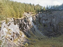
The area of particular interest in Mountfield Old Quarry is located at the top of the north-west face of the quarry where a pale green and silverish grey coloured mylonitic horizon marks the position of the Omagh Fault. The Omagh Fault is a low-angle south-easterly-directed thrust with Dalradian (Mullaghcarn Formation) in the hanging wall resting on basic lavas and tuffs (Tyrone Volcanic Group) in the footwall. The fault is marked by a 3m+ thick mylonite zone which dips uniformly at approximately 40 degrees NW. This horizon represents the cataclastically deformed and altered uppermost part of the Mullaghcarn Formation and rests directly on massive green and greenish black metabasalt and tuff of the Tyrone Volcanic Group. Unfortunately, poor exposure and forest cover along the north-western perimeter of the quarry precludes tracing the transition down dip from mylonite to less deformed rocks in the Mullaghcarn Formation. However, some indication of the original lithologies of the Mullaghcarn Formation can be gauged from small relatively undeformed fragments of grey quartz semipelite and micaceous quartz psammite found within the mylonitic clay matrix. | |
| Importance: | |
This site offers unique access to the plane of the Omagh Thrust, one of the most important structural discontinuities in Northern Ireland. It is also of international importance since it provides evidence of the nature of late-Caledonian to Variscan modification of the boundary between the Central Highlands (Grampian) Terrane and the Midland Valley Terrane. In Scotland, the boundary between these two terranes, the Highland Boundary Fault, remains at the heart of ongoing controversies related to the nature and timing of terrane amalgamation and is crucial to the understanding of the crustal evolution of Northern Britain. | |
| Interpretation: | |
A comparatively late-stage phase of Caledonian deformation (D3) resulted in the south-easterly-directed thrusting of folded and overturned Southern Highland Group (Upper Dalradian) strata over the arc related Ordovician volcanic succession in mid-Tyrone. The massive volcanic rocks in the footwall of the Omagh Thrust are brecciated and elsewhere, have been intensely deformed by a single penetrative cleavage which is sub-parallel to the thrust and extends some kilometres to the south-east. Alsop & Hutton (1993) proposed that this singular D1 event in the Tyrone Volcanic Group corresponds with the D3 in the Dalradian and is also related to south-easterly directed thrusting. There is evidence that the Omagh/Castle Archdale Fault system remained intermittently active throughout most of the Carboniferous Period, probably until Westphalian B times (about 310 Ma ago) when younger Phanerozoic rocks south of the fault system were still undergoing brittle and cataclastic deformation (Mitchell, 1992). As well as representing a major structural break, the Omagh Thrust separates terranes with distinctive thermal and metamorphic histories. | |
| Conclusions: | |
Mountfield Old Quarry is an important location which features regularly on geological excursions to the area, and has been cited frequently in the geological literature. The quarry offers an excellent opportunity to study structural and lithological aspects of the tectonic contact between the Dalradian and the Tyrone Volcanic Group. It has recently become apparent that a closer understanding of the nature and timing of this contact has an important bearing upon developing models for gold metallogeny in the Dalradian rocks of Northern Ireland. | |
| Notes: | |
For site specific information and references on other Dalradian sites in the Sperrin Mountains, Londonderry and Tyrone see the following sites: For Central and Southern Sperrin Mountains: Key Site 130 - Butterlope Glen Key Site 131 - Craig Key Site 132 - Mullaghcarbatagh Key Site 133 - Henry's Bridge, Glensass Burn Key Site 134 - Oughtboy Burn Key Site 135 - Garvagh Burn Key Site 136 - Barnes Gap Key Site 137 - Barnes Burn Key Site 138 - Golan Burn Key Site 139 - Glendarragh Burn, Glenlark Key Site 141 - McNally's Burn, Broughderg For North Sperrin Mountains and Londonderry: Key Site 142 - Letterbrat Quarry Key Site 143 - Banagher Glen Quarry Key Site 144 - Strabane Quarry Key Site 145 - Glenmornan River, Artigarvan Key Site 146 - Balix Hill Key Site 147 - Drain Quarry Key Site 148 - Kildoag Quarry Key Site 149 - Loughermore Mountain Key Site 150 - Burntollet and Tamnymore Wood Key Site 151 - Dog Leap, Limavady Key Site 152 - Kittybane Quarry Key Site 153 - Prehen Quarry Key Site 154 - Creevagh Hill Old Quarry For site specific information and references on other Dalradian sites in North-east Antrim see the following sites: Key Site 155 - Benvan Key Site 156 - Escort Port Key Site 157 - Torr Head Key Site 158 - Altmore Burn Key Site 159 - Leckpatrick Point Key Site 160 - Carnaneigh Key Site 161 - Loughan Bay Key Site 162 - Loughareema Channel Key Site 163 - Knocknacarry Bridge Key Site 164 - Cushendun Bay and Rock Port For general information on the Dalradian rocks of Northern Ireland see the following site: Key Site 124 - The Dalradian Rocks of Northern Ireland For general and site specific information on the Pre-Dalradian rocks of Northern Ireland see the following site: Key Site 123 - The Pre-Dalradian Rocks of Northern Ireland For general information and an extensive reference list on the Precambrian of Northern Ireland see the following site: Key Site 122 - An Introduction to the Precambrian of Northern Ireland This site is also important for Structural Geology. See Key Site 646 - Mountfield Quarry. | |
| Keywords | |
|---|---|
| Rocks: | Mylonite, Pelitic rock, Psammite, Semi-pelitic rock |
| Structures: | fault |
| Access | |
|---|---|
| Management: | |
Mountfield Old Quarry has been derelict for several years and there is no evidence of current usage or of dumpingfly-tipping. It is conceivable that in the future, this site may be considered either for further quarrying or development as a landfill. Neither scenario would necessarily be incompatible with conserving the site as an ASSI provided the area of primary geological interest, i.e. the uppermost part of the north-western face remained accessible to interested parties. From the point of view of safety, extreme care must be exercised when accessing the mylonite outcrop. Thick forest cover along the rim of the quarry forces access to be along the quarry edge and the mylonite can be extremely slippery especially in wet conditions. |
| References (7) | |||
|---|---|---|---|
| Alsop, G.I. & Hutton, D.H.W., 1993. Major southeast-directed Caledonian thrusting and folding in the Dalradian rocks of mid-Ulster: implications for Caledonian tectonics and mid-crustal shear zones Geological Magazine, vol. 130 pt. 2, pp.233-244. | |||
| Arthurs, J.W., 1976a. The geology and metalliferous mineral potential of the Sperrin Mountains area Geological Survey of Northern Ireland Special Report. | |||
| Arthurs, J.W., Johnston, T.P., Smith, R.A., Alsop, G.I. & Hutton, D.H.W., 1994. Discussion on major southeast-directed Caledonian thrusting and folding in the Dalradian rocks of mid-Ulster: Implications for Caledonian tectonics and mid-crustal shear zones Geological Magazine, vol. 131 pt. 3, pp.417-421. | |||
| Hartley, J.J., 1938. The Dalradian rocks of the Sperrin Mountains and adjacent areas in Northern Ireland Proceedings of the Royal Irish Academy, vol. 44 pt. B. | |||
| Mitchell, W.I., 1992. The origin of Upper Palaeozoic sedimentary basins in Northern Ireland and relationships with the Canadian Maritime Provinces. Special Publications of the Geological Society of London, vol. 62 In Basins on the Atlantic Seaboard: Petroleum Geology, Sedimentology and Basin Evolution., pp.191-202. | |||
| Nolan, J., 1884. Explanatory memoir to accompany Sheet 26 of the maps of the Geological Survey of Ireland Memoirs of the Geological Survey of Ireland. | |||
| Portlock, J.E., 1843. Report on the Geology of the County of Londonderry and of parts of Tyrone and Fermanagh. HMSO, Dublin. | |||
| Map(s): | GSI (1882). 1:63,360 Geological Sheet 26 (Draperstown), Dublin, OS for GSI GSNI (1995). 1:50,000 Draperstown, Northern Ireland Sheet 26, Solid, BGS, Keyworth, Nottingham | ||
| Record type: | ESCR report | ||
| Entered by: | E M Porter | ||
| Enlander, I., Dempster, M. & Doughty, P., 2026. Mountfield Old Quarry - Dalradian, County Tyrone, site details. [In] Earth Science Conservation Review. https://www.habitas.org.uk/escr/site.php?item=140. Accessed on 2026-11-06. |
| Previous Site | Next Site |