
| Previous Site | Next Site |
Earth Science Conservation Review
| Balix Hill | Tyrone |
| Site number: | 146 | ||
| ESCC: | ED | ||
| Locality Type: | Pit | Status: | ESCR |
| Grid Reference: | H480958 Centroid | ||
| Google maps: | 54.8082,-7.25348 | ||
| County: | Tyrone | Council area: | Derry City & Strabane District Council |
| Period: | Precambrian | ||
| Stages: | Dalradian | ||
| Lithostrat: | Dungiven Formation | ||
| Site Description | |
|---|---|
 | |
| Highlights: | |
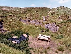
Abandoned limestone pits in the vicinity of a disused lime kiln on the slopes of Balix Hill, contain good exposures of one of several limestone members within the Dungiven Formation. The site offers an opportunity to study lithological variations within the limestone as well as important structural relationships. | |
| Introduction: | |
The site is located in a small abandoned limestone pit on enclosed rough pastureland, approximately 800m south-east of the summit of Balix Hill. Access to the site is via the track leading northwards from the bend on Crockrow Road [H480 957], 4.5 km north of Plumbridge. Although on the first edition of the one inch to one mile geological map (Geological Survey of Ireland, 1886), the limestone at nearby Butterlope Glen was shown as a mappable unit, the limestone at Balix Hill was not distinguished from the surrounding "mica schist". Arthurs (1976) included the Balix Hill limestone within the Dungiven Formation and his map shows this outcrop as part of a laterally more extensive, NE-SW striking limestone unit which is closely associated with metabasites and green beds. The Dungiven Formation, together with the Torr Head Limestone Formation in north-east Antrim, represents the topmost stratigraphic interval of the Argyll Group (Middle Dalradian) in Northern Ireland and has been correlated with limestones at comparable horizons in Donegal (Culdaff Limestone) and Scotland (Loch Tay Limestone) (Gower, 1972; Gibbons et al., 1994); see table below. TABLE TO BE ADDED Dalradian stratigraphy and ESCR sites in the northern Sperrin Mountains. | |
| Description: | |
The disused and partially infilled limestone pits on the southern slopes of Balix Hill contain high quality outcrop of thin (2-10cm thick) grey and bluish black limestones interbedded with thinner partings of black and silvery grey phyllite.
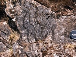 Bedding (S0) has a general strike of 015°60°ESE. The earliest cleavage (S1) appears to be more or less parallel to bedding or in parts slightly more steeply inclined. Both S0 and S1 dip ESE and are cut and in parts strongly crenulated by an S2 fabric axial planar to a number of minor concentric (F2?) folds. These folds plunge towards the north-east (020°30°N). Although some of these structures appear to have a neutral sense of vergence, the majority verge towards the south-east indicating that the Balix Hill strata lie on the upwards facing limb of a larger scale fold structure whose axis lies some distance to the south-east, possibly in the vicinity of Butterlope Glen. | |
| Importance: | |
This site affords a good opportunity to study lithology and structural relationships in limestone of the Dungiven Formation. For reasons outlined above, the Dungiven Formation is an important transitional interval within the Dalradian which will continue to be the focus of studies and efforts to establish detailed correlations between Northern Ireland, Ireland and Scotland. | |
| Interpretation: | |
The original sediments which formed the limestone and phyllites at this site were deposited in comparatively shallow-water marine shelf environment towards the end of the Middle Dalradian (Late Proterozoic). The Dungiven Formation represents a period of significant geological change in the Dalradian and mirrors similar changes recognised at this level in the Dalradian right across Ireland and Scotland. Under the influence of an increasingly extensional tectonic regime, the stable shelf environments which hitherto characterised much of the Argyll Group give way to more unstable conditions. Stretching and thinning of the continental crust along the south-eastern edge of the Laurentian plate was accompanied by a significant increase in basic volcanic activity. These events preceded the establishment of unstable marine depositional basins and the onset of predominantly turbidite facies conditions which were to dominate throughout Southern Highland Group (Upper Dalradian) times. In common with all Dalradian rocks in Britain and Ireland the limestone at Balix Hill, underwent regional deformation and metamorphism during the late Caledonian Orogeny. The limestones are extensively recrystallized and the outcrops, especially the phyllite interbeds, show clear evidence of at least two regionally significant phases of deformation. Mineral assemblages in volcanic green beds, metabasites and schists in the surrounding Dungiven Formation include chlorite, epidote, actinolite and albite indicating low-grade regional metamorphism under Greenschist Facies conditions. Cleavage and fold vergence at Balix Hill are consistent with these strata being located on the upwards facing limb of a major fold (Sperrin Overfold) with an axial trace trending NE-SW and plunging to the north-east. | |
| Conclusions: | |
This site contains features of national importance. The full measure of the significance of the site may however be subject to review as the mapping programme of the Geological Survey of Northern Ireland extends into this area in the near future. | |
| Notes: | |
For site specific information and references on other Dalradian sites in the Sperrin Mountains, Londonderry and Tyrone see the following sites: For Central and Southern Sperrin Mountains: Key Site 130 - Butterlope Glen Key Site 131 - Craig Key Site 132 - Mullaghcarbatagh Key Site 133 - Henry's Bridge, Glensass Burn Key Site 134 - Oughtboy Burn Key Site 135 - Garvagh Burn Key Site 136 - Barnes Gap Key Site 137 - Barnes Burn Key Site 138 - Golan Burn Key Site 139 - Glendarragh Burn, Glenlark Key Site 140 - Mountfield Old Quarry Key Site 141 - McNally's Burn, Broughderg For North Sperrin Mountains and Londonderry: Key Site 142 - Letterbrat Quarry Key Site 143 - Banagher Glen Quarry Key Site 144 - Strabane Quarry Key Site 145 - Glenmornan River, Artigarvan Key Site 147 - Drain Quarry Key Site 148 - Kildoag Quarry Key Site 149 - Loughermore Mountain Key Site 150 - Burntollet and Tamnymore Wood Key Site 151 - Dog Leap, Limavady Key Site 152 - Kittybane Quarry Key Site 153 - Prehen Quarry Key Site 154 - Creevagh Hill Old Quarry For site specific information and references on other Dalradian sites in North-east Antrim see the following sites: Key Site 155 - Benvan Key Site 156 - Escort Port Key Site 157 - Torr Head Key Site 158 - Altmore Burn Key Site 159 - Leckpatrick Point Key Site 160 - Carnaneigh Key Site 161 - Loughan Bay Key Site 162 - Loughareema Channel Key Site 163 - Knocknacarry Bridge Key Site 164 - Cushendun Bay and Rock Port For general information on the Dalradian rocks of Northern Ireland see the following site: Key Site 124 - The Dalradian Rocks of Northern Ireland For general and site specific information on the Pre-Dalradian rocks of Northern Ireland see the following site: Key Site 123 - The Pre-Dalradian Rocks of Northern Ireland For general information and an extensive reference list on the Precambrian of Northern Ireland see the following site: Key Site 122 - An Introduction to the Precambrian of Northern Ireland | |
| Keywords | |
|---|---|
| Rocks: | Limestone, Phyllite |
| Access | |
|---|---|
| Management: | |
At the time of the site visit there was no evidence of any significant encroachment on or threat to this site. However, lying as it does in an area of enclosed rough pasture, the site should be considered as being vulnerable to infilling or casual tipping which may accompany land improvements. |
| References (3) | |||
|---|---|---|---|
| Arthurs, J.W., 1976a. The geology and metalliferous mineral potential of the Sperrin Mountains area Geological Survey of Northern Ireland Special Report. | |||
| Gibbons, W. & Harris, A.L.(eds), 1994. A revised correlation of Precambrian rocks in the British Isles Geological Society of London Special Report, numb. 22. | |||
| Gower, P.J., 1972. The Middle-Upper Dalradian Boundary with special reference to the Loch Tay Limestone (Thesis) Unpublished PhD thesis, University of Liverpool. | |||
| Map(s): | GSI (1886). 1:63,360 Geological Sheet 25 (Newtown Stewart), Dublin, OS for GSI | ||
| Record type: | ESCR report | ||
| Entered by: | E M Porter | ||
| Enlander, I., Dempster, M. & Doughty, P., 2026. Balix Hill, County Tyrone, site details. [In] Earth Science Conservation Review. https://www.habitas.org.uk/escr/site.php?item=146. Accessed on 2026-11-04. |
| Previous Site | Next Site |