
| Previous Site | Next Site |
Earth Science Conservation Review
| Loughermore Mountain | Londonderry |
| Site number: | 149 | ||
| ESCC: | ED | ||
| Locality Type: | Quarry (disused) | Status: | ASSI |
| Grid Reference: | C606151 Centroid | ||
| Google maps: | 54.98017,-7.05349 | ||
| County: | Londonderry | Council area: | Causeway Coast & Glens Borough Council |
| Period: | Precambrian | ||
| Stages: | Dalradian | ||
| Lithostrat: | Claudy Formation, Southern Highlands Group | ||
| Site Description | |
|---|---|
 | |
| Highlights: | |
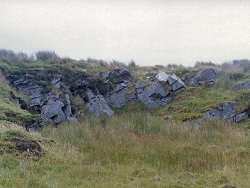
The rocks exposed at this locality are characteristic of the coarser grained quartz-wacke lithologies which form part of the Claudy Formation. The quarry, although small and partly overgrown, contains sufficient good quality exposure to allow identification of bedding, possible way up of bedding (younging) and major tectonic fabrics. | |
| Introduction: | |
This site is located about 1.5 km south-east of the summit of Loughermore Mountain and 2.5 km south-west of Baranailt. Access is gained from the minor road which runs parallel to the B69 from Baranailt Crossroads. The site is partially obscured from the road and access is across enclosed (fenced) rough pastureland. On the first edition of the one inch to one mile geological map (Dungiven, Sheet 18) (Geological Survey of Ireland, 1884) the strata here and in the surrounding area were included within the general category "chloritic, talcose & micaceous schists". The rocks at this site form part of the thick succession of metagreywackes at the core of a broad syncline centred on Lough Foyle (Lough Foyle Syncline). Pitcher et al. (1972) indicated that these rocks were of Upper Dalradian age and referred to them collectively as the Lough Foyle (Lough Awe) Succession. The first formal stratigraphic subdivision of the Lough Foyle Succession came as a result of mapping by the Geological Survey of Northern Ireland and the terms Claudy, Ballykelly and Londonderry formations were introduced on the 1:50,000 scale second edition of the Limavady Sheet (Geological Survey of Northern Ireland, 1981), see table below. This quarry contains representative strata of the Claudy Formation, a formation consisting primarily of schistose grits, quartz psammites, metagreywackes pelites and quartzites, (Arthurs, 1976). TABLE TO BE ADDED Dalradian stratigraphy and ESCR sites in the northern Sperrin Mountains. | |
| Description: | |
The site is a small disused quarry. The rocks are predominantly psammitic and range from medium to pebble grain size. Quartz and feldspar are the most common clast types. The grains are typically well-rounded. Characteristic blue quartz grains are present throughout. Grain size variations give the impression of graded bedding which could indicate that the succession is right way-up, and younging towards north. However, the structural overprinting makes identification of all original depositional features highly speculative. The principal and regionally dominant fabric (S2) is conspicuous throughout the quarry dipping at about 30°N with some variation due to cleavage refraction resulting from changes in lithology. Over much of the outcrop, S2 is broadly parallel to a composite fabric defined by coplanar bedding (S0) and an earlier cleavage (S1). However, there is some divergence of these fabrics and, on the western face of the quarry, a series of thinly bedded, medium-grained psammites is cut by well developed S2 which clearly crenulates an earlier composite S0/S1 fabric. | |
| Importance: | |
This site is ideally located to observe medium-grained to pebble grade psammitic lithologies typical of the Claudy Formation. It is possible to observe some sedimentological variations in this lithology (bedding) and to determine way up. The site also contains important information for determining regional structure. | |
| Interpretation: | |
The rocks exposed at this site formed as sediments deposited in an open marine basinal environment. The Claudy Formation consists primarily of quartz-wackes and appears to represent a facies that is transitional between the near-shore more stable, occasionally carbonate shelf and shallow water environments characteristic of the underlying Dungiven Formation and the deeper water turbidite facies of the succeeding Ballykelly Formation (Arthurs, 1976). Whilst the rocks at this site certainly appear to have originated from poorly sorted clastic sediments, details of the depositional environment cannot be confirmed from morphological evidence since all original sedimentary structures have been displaced or obliterated by deformation and southwards translation. The rocks at this site and in the surrounding area have experienced comparatively low-grade regional metamorphism associated with a regional scale deformation during the Caledonian Orogeny. The ubiquitous presence of metamorphic chlorite, white mica and occasional biotite porphyroblasts indicates metamorphic conditions probably within the quartz-albite-epidote-biotite sub-facies of the Greenschist Facies. Structurally, the site lies on the northern, upwards facing limb of the Sperrin Overfold, the major F2 structure in the Sperrin Mountains. The Claudy Formation outcrop at Loughermore Mountain occurs in the core of the Loughermore Refold (F1-F2) and is surrounded by outcrops of the Ballykelly Formation (Arthurs, 1976, Geological Survey of Northern Ireland, 1997). | |
| Conclusions: | |
The site warrants conservation on the basis of its local (national) importance. This is an informative locality which contains important lithological and structural information relating to the Claudy Formation. The location of the site within the core of the Loughermore Refold is a factor which adds to the interest of the site. | |
| Notes: | |
For site specific information and references on other Dalradian sites in the Sperrin Mountains, Londonderry and Tyrone see the following sites: For Central and Southern Sperrin Mountains: Key Site 130 - Butterlope Glen Key Site 131 - Craig Key Site 132 - Mullaghcarbatagh Key Site 133 - Henry's Bridge, Glensass Burn Key Site 134 - Oughtboy Burn Key Site 135 - Garvagh Burn Key Site 136 - Barnes Gap Key Site 137 - Barnes Burn Key Site 138 - Golan Burn Key Site 139 - Glendarragh Burn, Glenlark Key Site 140 - Mountfield Old Quarry Key Site 141 - McNally's Burn, Broughderg For North Sperrin Mountains and Londonderry: Key Site 142 - Letterbrat Quarry Key Site 143 - Banagher Glen Quarry Key Site 144 - Strabane Quarry Key Site 145 - Glenmornan River, Artigarvan Key Site 146 - Balix Hill Key Site 147 - Drain Quarry Key Site 148 - Kildoag Quarry Key Site 150 - Burntollet and Tamnymore Wood Key Site 151 - Dog Leap, Limavady Key Site 152 - Kittybane Quarry Key Site 153 - Prehen Quarry Key Site 154 - Creevagh Hill Old Quarry For site specific information and references on other Dalradian sites in North-east Antrim see the following sites: Key Site 155 - Benvan Key Site 156 - Escort Port Key Site 157 - Torr Head Key Site 158 - Altmore Burn Key Site 159 - Leckpatrick Point Key Site 160 - Carnaneigh Key Site 161 - Loughan Bay Key Site 162 - Loughareema Channel Key Site 163 - Knocknacarry Bridge Key Site 164 - Cushendun Bay and Rock Port For general information on the Dalradian rocks of Northern Ireland see the following site: Key Site 124 - The Dalradian Rocks of Northern Ireland For general and site specific information on the Pre-Dalradian rocks of Northern Ireland see the following site: Key Site 123 - The Pre-Dalradian Rocks of Northern Ireland For general information and an extensive reference list on the Precambrian of Northern Ireland see the following site: Key Site 122 - An Introduction to the Precambrian of Northern Ireland | |
| Keywords | |
|---|---|
| Rocks: | Greywacke, Metagreywacke, Psammite |
| Access | |
|---|---|
| Management: | |
This site is presently in a good state of preservation although there has been some tipping. The main threat to the site in the future is further farm dumping, infilling or fly-tipping. The relatively small size of the quarry pit and the limited amount of the existing exposure requires that sampling should be maintained at a sustainable level. Alternatively, consideration should be given to opening and cleaning parts of the quarry face which are now overgrown. Access to the site will also have to be considered carefully. Currently it is via fenced rough pastureland and parking is difficult on the nearby narrow road. | |
| Threats: | The main threat to the site in the future is further farm dumping, infilling or fly-tipping. |
| References (2) | |||
|---|---|---|---|
| Arthurs, J.W., 1976a. The geology and metalliferous mineral potential of the Sperrin Mountains area Geological Survey of Northern Ireland Special Report. | |||
| Pitcher, W.S. & Berger, A.R., 1972. The Geology of Donegal: A study of granite emplacement and unroofing Wiley - Interscience, New York & London. | |||
| Map(s): | GSI (1884). 1:63,360 Geological Sheet 18 (Dungiven), Dublin, OS for GSI GSNI (1981). 1:50,000 Limavady, Northern Ireland Sheet 12 and part of Sheet 6, Solid, Southampton, OS for GSNI GSNI (1997). 1:250,000 Northern Ireland, Solid Geology (2nd edition), BGS, Keyworth, Nottingham | ||
| Record type: | ESCR report | ||
| Entered by: | E M Porter | ||
| Enlander, I., Dempster, M. & Doughty, P., 2026. Loughermore Mountain, County Londonderry, site details. [In] Earth Science Conservation Review. https://www.habitas.org.uk/escr/site.php?item=149. Accessed on 2026-11-06. |
| Previous Site | Next Site |