
| Previous Site | Next Site |
Earth Science Conservation Review
| Dog Leap, Limavady | Londonderry |
| Site number: | 151 | ||
| ESCC: | EO | ||
| Locality Type: | Stream section | Status: | ESCR |
| Grid Reference: | C674203 Centroid | ||
| Google maps: | 55.026,-6.94608 | ||
| County: | Londonderry | Council area: | Causeway Coast & Glens Borough Council |
| Period: | Precambrian | ||
| Stages: | Dalradian | ||
| Lithostrat: | Ballykelly Formation | ||
| Site Description | |
|---|---|
 | |
| Highlights: | |
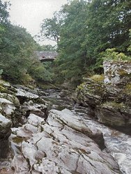
The rocks exposed at the Dog Leap in the River Roe are typical of the Ballykelly Formation. Exposures are easily accessible and form a series of water worn weirs and riverside cliffs where it is possible to demonstrate the complex lithological variation and structure of the rocks. | |
| Introduction: | |
The Dog Leap is located within the Roe Valley Country Park, approximately 3km SSW of Limavady, County Londonderry. The site can be accessed from the B192 or the B68 by turning onto the Dog Leap Road. A path leading from the visitors centre to the south-western bank of the River Roe allows direct access to the site. The rocks at Dog Leap are structurally complex and mixed psammite and pelitic schists which form part of the Ballykelly Formation (Southern Highland Group) (Upper Dalradian). On the first edition of the one inch to one mile geological map (Limavady, Sheet 12) (Geological Survey of Ireland, 1884) these strata were included within the general category "mica schist" part of the "Altered Lower Silurian Beds". The rocks at this site form part of a thick succession of metagreywackes which lie at the core of a broad syncline centred on Lough Foyle. Pitcher et al. (1972) referred to this sequence of Upper Dalradian rocks jointly as the Lough Foyle (Lough Awe) Succession. The first formal stratigraphic subdivision of the Lough Foyle Succession came as a result of mapping by the Geological Survey of Northern Ireland and the terms Claudy, Ballykelly and Londonderry Formation were first introduced on the 1:50,000 scale second edition of the Limavady Sheet (Geological Survey of Northern Ireland, 1981), see table below. Arthurs (1976) has described the Ballykelly Formation as a series of metagreywackes and slates with occasional thin limestones and epidiorites. A more detailed account of the Ballykelly Formation in the area around this site is contained in Bazley et al. (1997). TABLE TO BE ADDED Dalradian stratigraphy and ESCR sites in the northern Sperrin Mountains. | |
| Description: | |
For a distance of about 100m upstream from Largy Bridge [C679 203] at the Dog Leap the rocks consist of mixed psammite and pelitic lithologies and are exposed in a series of natural weirs. Quartz veins are also present. The structure is complex and deformation has involved varying degrees of folding, shearing, faulting and jointing. The most striking feature of these outcrops is the dominant fabric which dips at 30°to 40°NW. This is a regionally penetrative S2 cleavage which strongly crenulates and transposes an earlier composite S0?S1 (pressure solution) fabric. The pressure solution cleavage (S1) is best seen in psammite units where it is in the form of a small scale lithological banding comprising millimetre-scale alternations of pale coloured quartzo-feldspathic psammitic and dark green chloritic and micaceous semipelites. The crenulation of the S1 surfaces results in a distinctive herring bone appearance in the rocks throughout the site and in the surrounding area. All these structures can best be viewed on the northern bank of the river. Complex folding and shearing can also be seen on water polished surfaces on the southern bank. | |
| Importance: | |
This site warrants conservation because of its local importance. It is one of only a few exposures of this size and quality in the Ballykelly Formation that offers easy and safe access to useful structural and lithological information. The site provides important clues to the regional stratigraphy and structure. | |
| Interpretation: | |
The strata at Dog Leap and in the surrounding area formed mainly from poorly sorted sediments believed to have been deposited in an open marine basin environment by turbidity currents. These rocks represent a significant transition from the nearer shore more stable and shallower water environments which characterise the underlying Claudy Formation. Arthurs (1976) referred to the rocks of the Ballykelly Formation as metagreywackes. Whilst the rocks at this site certainly appear to have originated from poorly sorted clastic sediments this cannot be confirmed from morphological evidence since the majority of original sedimentary structures have been displaced or obliterated by deformation. Rocks at this site, have experienced regional scale deformation accompanied by a generally low-grade metamorphism. The ubiquitous presence of minerals such as chlorite, epidote, muscovite quartz and albite indicates metamorphic conditions probably within the quartz-albite-muscovite-chlorite sub-facies of the Greenschist Facies. Structurally this site lies on the northern, upwards facing limb of the Sperrin Overfold. This is now interpreted as being a major F2 structure (Arthurs, 1976) although at the time of the resurvey of the area (1968-73), it was referred to as an F1 structure (Bazley et al.,1997). Minor structures at Dog Leap appear to confirm the more modern structural interpretation. Tight minor scale folds which are particularly well developed in the softer phyllitic lithologies, have axes which plunge consistently towards east-north-east. The regionally dominant S2 cleavage is axial planar to these folds. Fold rotation (vergence) and crenulation transposition along S2 both show a top towards south-east sense of translation. | |
| Conclusions: | |
There is undoubtedly a strong case for conserving this site as a locally (nationally) important section through part of the Ballykelly Formation and as a site where local structure and deformation can be studied. In time, the site may also help shed light on some of the unanswered questions relating to the overall structure of the Sperrin Mountains and perhaps more significantly, structural relationships between the Dalradian in Londonderry and east Donegal. | |
| Notes: | |
For site specific information and references on other Dalradian sites in the Sperrin Mountains, Londonderry and Tyrone see the following sites: For Central and Southern Sperrin Mountains: Key Site 130 - Butterlope Glen Key Site 131 - Craig Key Site 132 - Mullaghcarbatagh Key Site 133 - Henry's Bridge, Glensass Burn Key Site 134 - Oughtboy Burn Key Site 135 - Garvagh Burn Key Site 136 - Barnes Gap Key Site 137 - Barnes Burn Key Site 138 - Golan Burn Key Site 139 - Glendarragh Burn, Glenlark Key Site 140 - Mountfield Old Quarry Key Site 141 - McNally's Burn, Broughderg For North Sperrin Mountains and Londonderry: Key Site 142 - Letterbrat Quarry Key Site 143 - Banagher Glen Quarry Key Site 144 - Strabane Quarry Key Site 145 - Glenmornan River, Artigarvan Key Site 146 - Balix Hill Key Site 147 - Drain Quarry Key Site 148 - Kildoag Quarry Key Site 149 - Loughermore Mountain Key Site 150 - Burntollet and Tamnymore Wood Key Site 152 - Kittybane Quarry Key Site 153 - Prehen Quarry Key Site 154 - Creevagh Hill Old Quarry For site specific information and references on other Dalradian sites in North-east Antrim see the following sites: Key Site 155 - Benvan Key Site 156 - Escort Port Key Site 157 - Torr Head Key Site 158 - Altmore Burn Key Site 159 - Leckpatrick Point Key Site 160 - Carnaneigh Key Site 161 - Loughan Bay Key Site 162 - Loughareema Channel Key Site 163 - Knocknacarry Bridge Key Site 164 - Cushendun Bay and Rock Port For general information on the Dalradian rocks of Northern Ireland see the following site: Key Site 124 - The Dalradian Rocks of Northern Ireland For general and site specific information on the Pre-Dalradian rocks of Northern Ireland see the following site: Key Site 123 - The Pre-Dalradian Rocks of Northern Ireland For general information and an extensive reference list on the Precambrian of Northern Ireland see the following site: Key Site 122 - An Introduction to the Precambrian of Northern Ireland | |
| Keywords | |
|---|---|
| Rocks: | Pelitic rock, Psammite |
| Access | |
|---|---|
| Approach: | The site can be accessed from the B192 or the B68 by turning onto the Dog Leap Road. A path leading from the visitors centre to the south-western bank of the River Roe allows direct access to the site. |
| Management: | |
Dog Leap site lies within the Roe Valley Country Park and therefore should not pose any major conservation problems. Access to the exposures can be gained safely via existing paths. At times of low river flow, the water worn and polished rock surfaces in the riverbed offer a great opportunity to study rock lithology and structural relationships at close hand. The site contains particularly good water worn polished outcrops where structure can be seen to best advantage. It would therefore be well worth considering imposing a hammering ban at this site. Extreme care must be exercised when accessing parts of this site. Parts of the outcrop becomes treacherous at times of high water flow and when the rock surfaces are wet. | |
| References (2) | |||
|---|---|---|---|
| Arthurs, J.W., 1976a. The geology and metalliferous mineral potential of the Sperrin Mountains area Geological Survey of Northern Ireland Special Report. | |||
| Bazley, R.A.B., Brandon, A. & Arthurs, J.W., 1997. Geology of the Country around Limavady and Londonderry GSNI Technical Report 97/1. | |||
| Map(s): | GSI (1884). 1:63,360 Geological Sheet 12 (Newtown Limavady), Dublin, OS for GSI GSNI (1981). 1:50,000 Limavady, Northern Ireland Sheet 12 and part of Sheet 6, Solid, Southampton, OS for GSNI | ||
| Record type: | ESCR report | ||
| Entered by: | E M Porter | ||
| Enlander, I., Dempster, M. & Doughty, P., 2026. Dog Leap, Limavady, County Londonderry, site details. [In] Earth Science Conservation Review. https://www.habitas.org.uk/escr/site.php?item=151. Accessed on 2026-11-07. |
| Previous Site | Next Site |