
| Previous Site | Next Site |
Earth Science Conservation Review
| Kittybane Quarry, Prehen | Londonderry |
| Site number: | 152 | ||
| ESCC: | ED | ||
| Locality Type: | Quarry (disused) | Status: | ESCR |
| Grid Reference: | C422136 Centroid | ||
| Google maps: | 54.9686,-7.34107 | ||
| County: | Londonderry | Council area: | Derry City & Strabane District Council |
| Period: | Precambrian | ||
| Stages: | Dalradian | ||
| Lithostrat: | Ballykelly Formation | ||
| Site Description | |
|---|---|
 | |
| Highlights: | |
This quarry affords access to good quality, three dimensional exposure of a meta-greywacke/slate succession. Relatively low-strain and low-grade regional metamorphism means that original sedimentary structures are clearly visible and relationships between bedding and cleavage can also be seen. | |
| Introduction: | |
Kittybane Quarry is located on a rock cored ridge overlooking the right bank of the River Foyle about 3km south-south-west of Londonderry. Access to the site is via Woodside Road between New Buildings and the Waterside in Londonderry. On the first edition of the one inch to one mile geological map of the area (Strabane, Sheet 17) (Geological Survey of Ireland, 1888) these strata were included within the general category "mica schists". In the accompanying Memoir (Kinahan et al., 1889) reference was made to the great variety of lithologies within the "mica schist" which is noted as, "passing gradually into sericitic phyllite and this again into roofing slate". Reference is also made to the fact that some tracts of ground have, "undergone but slight alteration during the epoch of metamorphism . . . and have a strong resemblance to some of the fossiliferous beds of Lower Silurian age in North Wales". Interestingly, Seymour (Wilkinson et al., 1908) drew attention to the fact that the strata in the area around Londonderry also compare very closely with the "Ballygowan grits of County Down". On the Geology Map of Northern Ireland (Geological Survey of Northern Ireland, 1977), these strata were included within the Lough Foyle Succession. A revised stratigraphic terminology was used on the second edition of this map (Geological Survey of Northern Ireland, 1997). This was based on the lithostratigraphic nomenclature used on the Londonderry and Limavady 1:50,000 sheets (Geological Survey of Northern Ireland, 1981, 1995, Bazley et al., 1997). The rocks at Kittybane Quarry form part of the thick succession of metagreywackes which lie at the core of a broad syncline centred on Lough Foyle (Lough Foyle Syncline). Pitcher et al. (1972) indicated that these rocks were of Upper Dalradian age and referred to them collectively as the Lough Foyle (Lough Awe) Succession. The first formal stratigraphic subdivision of the Lough Foyle Succession came as a result of mapping by the Geological Survey of Northern Ireland. The terms Claudy, Ballykelly and Londonderry formations were introduced on the 1:50,000 scale, second editions of the Limavady and Londonderry Sheets (Geological Survey of Northern Ireland, 1981, 1995). More precise stratigraphic definition of the strata at Kittybane Quarry and the surrounding area awaits the forthcoming resurvey of the Strabane (Sheet 17). In the meantime, these rocks can probably be included within the upper part of the Ballykelly Formation (Southern Highland Group), see table below. TABLE TO BE ADDED Dalradian stratigraphy and ESCR sites in the northern Sperrin Mountains. | |
| Description: | |
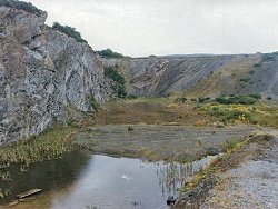
Kittybane Quarry was active until comparatively recently and contains abundant fresh outcrop which is accessible, with care, along vertical faces especially on the northern side of the quarry. The northern and western faces of the quarry consist of alternating metagreywackes and thin phyllite. These strata are comparatively weakly deformed and as a consequence many original sedimentary features are well preserved, as are relationships between bedding and cleavage. Individual greywacke units are massive and are up to 1m thick. They are medium to coarse-grained and granular and occasionally contain angular black shale clasts. Otherwise, the main mineral assemblage is quartz, feldspar and biotite. Some greywacke units show variation in grain size and are, in parts, coarse and gritty. However, unambiguous grading or way up indicators are difficult to find. The greenish blue phyllite, which is interbedded with the greywacke, retains many original fine sedimentary laminations, variegation and sedimentary features despite deformation and metamorphism. Beddingcleavage relationships are clearly seen throughout the quarry and are particularly well developed along the western face, close to the entrance of the site. Bedding (S0) dips steeply (60°NW) whereas a variably intense cleavage (S2?), which is more or less coplanar with bedding, is generally more gently dipping at about 50°NW. | |
| Importance: | |
This site contains high quality outcrop of the Ballykelly Formation on the southern limb of the Lough Foyle Syncline. Because the rocks are relatively undeformed, in comparison with Dalradian strata further south in the Sperrins, many original sedimentary structures are preserved and it is possible to study the sedimentary protolith in more detail. | |
| Interpretation: | |
The rocks at this site were originally deposited as distal turbidites in an open water marine environment within a trough or basin that was gradually subsiding to accommodate an accumulating pile of sediments (Bazley, 1997). Currently there is limited petrological or sedimentological data available to indicate the probable provenance of these sediments. During the Caledonian Orogeny, this turbidite succession, in common with Dalradian rocks elsewhere in the British Isles, underwent a major regional deformation and metamorphism. As a result of folding and south-easterly directing translation, the rocks at this site now lie structurally on the northern, upwards facing limb of the Sperrin Overfold which forms the complementary southern limb of the Lough Foyle Syncline. These two major structures have been interpreted as the south-westerly continuations of the Tay Nappe and the Loch Awe Syncline in Scotland (Pitcher et al., 1972, Bazley et al. 1997). The metamorphism that accompanied deformation was comparatively low-grade. The common occurrence of quartz chlorite and epidote assemblages in these rocks is consistent with metamorphism in the quartz-albite-muscovite-chlorite sub-facies of the Greenschist Facies. | |
| Conclusions: | |
There is a strong case for conserving this site for its local interest and national importance. The comparatively low-strain character of the rocks at this site offers an opportunity for possible future studies of the sedimentary protolith of the uppermost part of the Ballykelly Formation. | |
| Notes: | |
For site specific information and references on other Dalradian sites in the Sperrin Mountains, Londonderry and Tyrone see the following sites: For Central and Southern Sperrin Mountains: Key Site 130 - Butterlope Glen Key Site 131 - Craig Key Site 132 - Mullaghcarbatagh Key Site 133 - Henry's Bridge, Glensass Burn Key Site 134 - Oughtboy Burn Key Site 135 - Garvagh Burn Key Site 136 - Barnes Gap Key Site 137 - Barnes Burn Key Site 138 - Golan Burn Key Site 139 - Glendarragh Burn, Glenlark Key Site 140 - Mountfield Old Quarry Key Site 141 - McNally's Burn, Broughderg For North Sperrin Mountains and Londonderry: Key Site 142 - Letterbrat Quarry Key Site 143 - Banagher Glen Quarry Key Site 144 - Strabane Quarry Key Site 145 - Glenmornan River, Artigarvan Key Site 146 - Balix Hill Key Site 147 - Drain Quarry Key Site 148 - Kildoag Quarry Key Site 149 - Loughermore Mountain Key Site 150 - Burntollet and Tamnymore Wood Key Site 151 - Dog Leap, Limavady Key Site 153 - Prehen Quarry Key Site 154 - Creevagh Hill Old Quarry For site specific information and references on other Dalradian sites in North-east Antrim see the following sites: Key Site 155 - Benvan Key Site 156 - Escort Port Key Site 157 - Torr Head Key Site 158 - Altmore Burn Key Site 159 - Leckpatrick Point Key Site 160 - Carnaneigh Key Site 161 - Loughan Bay Key Site 162 - Loughareema Channel Key Site 163 - Knocknacarry Bridge Key Site 164 - Cushendun Bay and Rock Port For general information on the Dalradian rocks of Northern Ireland see the following site: Key Site 124 - The Dalradian Rocks of Northern Ireland For general and site specific information on the Pre-Dalradian rocks of Northern Ireland see the following site: Key Site 123 - The Pre-Dalradian Rocks of Northern Ireland For general information and an extensive reference list on the Precambrian of Northern Ireland see the following site: Key Site 122 - An Introduction to the Precambrian of Northern Ireland | |
| Keywords | |
|---|---|
| Rocks: | Greywacke, Metagreywacke, Phyllite |
| Structures: | syncline |
| Access | |
|---|---|
| Management: | |
This quarry appears to have reached or to be approaching the end of its working life. Rock extraction has stopped and parts of the quarry floor are now flooded. There is also evidence that the quarry is being used as a landfill site, albeit on a limited scale at present. To date the infill material consists mainly of builders rubble. The principle areas of geological interest can be viewed at many alternative points along the extensive quarry faces. Providing some continuing access is maintained to part of the quarry face, the conservation value of this site need not be seriously compromised either by renewed quarrying or by controlled operation as a landfill. There is no need to impose any sampling restrictions at the site. As with all quarries, care must be taken when examining the quarry faces. All such areas are potentially unstable and rockfalls can be precipitated by hammering or moving across unstable boulder screes. The flooded floor of the quarry also poses a potential hazard at this site. |
| References (4) | |||
|---|---|---|---|
| Bazley, R.A.B., Brandon, A. & Arthurs, J.W., 1997. Geology of the Country around Limavady and Londonderry GSNI Technical Report 97/1. | |||
| Kinahan, G.H., Wilkinson, S.B., Nolan, J. & Eagan, B.A., 1889. Explanatory Memoir to accompany Sheet 17 of the maps of the Geological Survey of Ireland Memoirs of the Geological Survey of Ireland. | |||
| Pitcher, W.S. & Berger, A.R., 1972. The Geology of Donegal: A study of granite emplacement and unroofing Wiley - Interscience, New York & London. | |||
| Wilkinson, S.B., McHenry, A., Kilroe, J.R. & Seymour, H.J., 1908. The geology of the country around Londonderry Memoirs of the Geological Survey of Ireland, HMSO, Dublin. | |||
| Map(s): | GSI (1888). 1:63,360 Geological Sheet 17 (Strabane), Dublin, OS for GSI GSNI (1981). 1:50,000 Limavady, Northern Ireland Sheet 12 and part of Sheet 6, Solid, Southampton, OS for GSNI GSNI (1997). 1:250,000 Northern Ireland, Solid Geology (2nd edition), BGS, Keyworth, Nottingham | ||
| Record type: | ESCR report | ||
| Entered by: | E M Porter | ||
| Enlander, I., Dempster, M. & Doughty, P., 2026. Kittybane Quarry, Prehen, County Londonderry, site details. [In] Earth Science Conservation Review. https://www.habitas.org.uk/escr/site.php?item=152. Accessed on 2026-11-06. |
| Previous Site | Next Site |