
| Previous Site | Next Site |
Earth Science Conservation Review
| Benvan - Dalradian | Antrim |
| Site number: | 155 | ||
| ESCC: | EO | ||
| Locality Type: | Crag, Crags | Status: | ASSI |
| Grid Reference: | D205415 Centroid | ||
| Google maps: | 55.2063,-6.10721 | ||
| County: | Antrim | Council area: | Causeway Coast & Glens Borough Council |
| Period: | Precambrian | ||
| Stages: | Dalradian | ||
| Lithostrat: | Argyll Group, Owencam Formation | ||
| Site Description | |
|---|---|
 | |
| Highlights: | |
Benvan contains accessible outcrops of the Owencam Formation, Argyll Group (Middle Dalradian) which are amongst the oldest Dalradian strata exposed in north-east Antrim. | |
| Introduction: | |
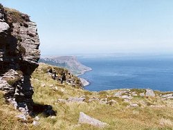
Benvan is an isolated site located between the southern end of Murlough Bay and the northern slopes of Greenanmore (282m O.D.). The site consists of a series of rocky knolls and crags in open moorland and fenced pastureland. Access to the site is via the farm track leading north from Torr Road [D194 405] or by scrambling up slopes at the southern end of Murlough Bay. On the first edition of the one inch to one mile geological map of the Ballycastle area (Sheet 8) (Geological Survey of Ireland, 1887), the rocks at Benvan were loosely classified and referred to by the general term "crystalline schists". McCallien (1931) produced the earliest detailed lithostratigraphic map of north-east Antrim and adopted the Dalradian lithostratigraphic nomenclature already in use in Scotland. McCallien's stratigraphy was predicated on a structural interpretation which viewed the area as the south-westerly continuation of the regional-scale recumbent fold structures already identified on the Cowal Peninsula, south-west Scotland (Gunn, 1897). On their map of north-east Antrim, Bailey & McCallien (1934) referred to all of the Dalradian strata NW of the Torr Head Limestone (equivalent to the Lough Tay Limestone) as the Ben Lui Schists. The second edition of the Ballycastle Sheet, (Geological Survey of Northern Ireland, 1963) and the accompanying Memoir (Wilson et al., 1966) contained a revised Dalradian lithostratigraphy based on new detailed mapping of the area. The strata in the area including Benvan were now referred to generally as "Quartzose mica-schist". A more formal approach to lithostratigraphic terminology for the Dalradian rocks in north-east Antrim was introduced on the first edition of the Solid Geology Map of Northern Ireland (Geological Survey of Northern Ireland, 1977) and, for the first time, local formation names were applied. All Dalradian strata NW of the Torr Head Limestone were henceforth referred to as the Murlough Bay Schists (later modified in parts to the Owencam Formation), see table below. Arthurs (1976) was responsible for a major revision and new lithostratigraphic framework for the Dalradian in north-east Antrim. Although Arthurs' work was based on reconnaissance mapping, and further detailed work is required in this area, this linework and lithostratigraphy was incorporated in the second edition of the Solid Geology Map of Northern Ireland (Geological Survey of Northern Ireland, 1997). TABLE TO BE ADDED Dalradian stratigraphy and ESCR sites in North-east Antrim. | |
| Description: | |
The site contains a number of crags defined by NW-SE trending faults around the south-eastern rim of the natural amphitheatre of Murlough Bay. Exposures are mainly of interbedded massive, coarse feldspathic grit, quartz-schist (psammite) and quartz-mica-schist (semi-pelite) together with some minor interbeds of pale green chlorite schist (green beds?). These lithologies are generally typical of the Owencam Formation (Crinan Subgroup, Argyll Group). Outcrops at Benvan have a distinctive ribbed appearance due to the development of thin ribbon-like quartz segregations and boudins parallel to the regionally dominant and locally penetrative spaced S2 cleavage which typically dips at 30°NW. This S2 fabric is a crenulation (strain-slip) cleavage which deforms an earlier composite S1S0 involving bedding? +/- an earlier pressure-solution cleavage. Locally, these structures impart a distinctive herring-bone appearance to the outcrop. 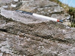 Rocks in the vicinity of Benvan are strongly lineated with one lineation dipping north-west in the direction of dip of the main foliation, and a second intersection lineation which is broadly parallel to strike. | |
| Importance: | |
Benvan is a site of national importance containing strata representative of the Owencam Formation, close to the core of the Altmore Fold. At this site there are outcrops of a number of lithological variants typical of the Owencam Formation together with features of general structural interest. | |
| Interpretation: | |
The rocks at Benvan (Owencam Formation) form part of the Argyll Group (Middle Dalradian) and are amongst the oldest of the Dalradian strata exposed in north-east Antrim. They formed originally from predominantly siliciclastic sediments that were eroded from source areas on the nearby continental margin and deposited by turbidity currents in marginal basins. During the Caledonian Orogeny these rocks were intensely deformed and regionally metamorphosed. In north-east Antrim, as in Scotland and the Sperrin Mountains, polyphase deformation resulted in the formation of up to four recognisable fold phases and related cleavages (Arthurs, 1976; Goldring, 1961). Structurally, the rocks at Benvan are the oldest in the area and lie close to the core of the Altmore Anticline regarded as the south-westerly continuation into Ireland of the Cowal Anticline in SW Scotland (Gunn, 1892; Arthurs, 1976). The metamorphism which accompanied deformation in this area was a comparatively low-grade event. Metamorphic mineral assemblages in the rocks at Benvan indicate metamorphism within the quartz- albite-muscovite-chlorite sub-facies of the Greenschist Facies. | |
| Conclusions: | |
Benvan is a site of national geological importance offering access to high quality exposure of a variety of lithologies representative of the Owencam Formation. The site lies on the periphery of Murlough Bay in an area of outstanding scenic beauty and within an existing National Trust Nature Reserve. | |
| Notes: | |
For site specific information and references on other Dalradian sites in North-east Antrim see the following sites: Key Site 156 - Escort Port Key Site 157 - Torr Head Key Site 158 - Altmore Burn Key Site 159 - Leckpatrick Point Key Site 160 - Carnaneigh Key Site 161 - Loughan Bay Key Site 162 - Loughareema Channel Key Site 163 - Knocknacarry Bridge Key Site 164 - Cushendun Bay and Rock Port For site specific information and references on other Dalradian sites in the Sperrin Mountains, Londonderry and Tyrone see the following sites: For Central and Southern Sperrin Mountains: Key Site 130 - Butterlope Glen Key Site 131 - Craig Key Site 132 - Mullaghcarbatagh Key Site 133 - Henry's Bridge, Glensass Burn Key Site 134 - Oughtboy Burn Key Site 135 - Garvagh Burn Key Site 136 - Barnes Gap Key Site 137 - Barnes Burn Key Site 138 - Golan Burn Key Site 139 - Glendarragh Burn, Glenlark Key Site 140 - Mountfield Old Quarry Key Site 141 - McNally's Burn, Broughderg For North Sperrin Mountains and Londonderry: Key Site 142 - Letterbrat Quarry Key Site 143 - Banagher Glen Quarry Key Site 144 - Strabane Quarry Key Site 145 - Glenmornan River, Artigarvan Key Site 146 - Balix Hill Key Site 147 - Drain Quarry Key Site 148 - Kildoag Quarry Key Site 149 - Loughermore Mountain Key Site 150 - Burntollet and Tamnymore Wood Key Site 151 - Dog Leap, Limavady Key Site 152 - Kittybane Quarry Key Site 153 - Prehen Quarry Key Site 154 - Creevagh Hill Old Quarry For general information on the Dalradian rocks of Northern Ireland see the following site: Key Site 124 - The Dalradian Rocks of Northern Ireland For general and site specific information on the Pre-Dalradian rocks of Northern Ireland see the following site: Key Site 123 - The Pre-Dalradian Rocks of Northern Ireland For general information and an extensive reference list on the Precambrian of Northern Ireland see the following site: Key Site 122 - An Introduction to the Precambrian of Northern Ireland This site is also important for Structural Geology. See Key Site 649 - Benvan, Murlough. | |
| Keywords | |
|---|---|
| Rocks: | Green beds, Pelitic rock, Psammite, Semi-pelitic rock |
| Access | |
|---|---|
| Management: | |
Benvan is located entirely within the Murlough Bay Nature Reserve currently managed by the National Trust. The site consists of a number of separate crags located in open heather-covered moorland. The main points of geological interest are of a general nature and in view of the plentiful outcrop, there is no need to impose a hammering ban or sampling restrictions at this site. |
| References (6) | |||
|---|---|---|---|
| Arthurs, J.W., 1976a. The geology and metalliferous mineral potential of the Sperrin Mountains area Geological Survey of Northern Ireland Special Report. | |||
| Bailey, E.B. & McCallien, W.J., 1934. The metamorphic rocks of North-east Antrim Transactions of the Royal Society of Edinburgh: Earth Sciences, vol. 58, pp.163-177. | |||
| Golding, D.C., 1961. The relationship of the micro-fabric to the small-scale structures of the Dalradian of north-eastern Antrim Proceedings of the Royal Irish Academy, vol. 61 pt. B, pp.345-367. | |||
| Gunn, W., Clough, C.T. & Hill, J.B., 1897. The Geology of Cowal Memoir of the Geological Survey of Scotland. | |||
| McCallien, W.J., 1931. A contribution to the correlation of the Dalradian rocks of Scotland Geological Magazine, vol. 68, pp.153-175. | |||
| Wilson, H.E. & Robbie, J.A., 1966. Geology of the country around Ballycastle. Memoirs of the Geological Survey Northern Ireland. | |||
| Map(s): | GSI (1887). 1:63,360 Geological Sheet 8 (Ballycastle), Dublin, OS for GSI GSNI (1963). 1:63,360 Ballycastle, Northern Ireland Sheet 8, Drift, Southampton, OS for GSNI GSNI (1977). 1:250,000 Northern Ireland, Solid Geology (1st edition), Southampton, OS for IGS GSNI (1997). 1:250,000 Northern Ireland, Solid Geology (2nd edition), BGS, Keyworth, Nottingham | ||
| Record type: | ESCR report | ||
| Entered by: | E M Porter | ||
| Last updated: | 23 Dec 2003 | ||
| Enlander, I., Dempster, M. & Doughty, P., 2026. Benvan - Dalradian, County Antrim, site details. [In] Earth Science Conservation Review. https://www.habitas.org.uk/escr/site.php?item=155. Accessed on 2026-11-05. |
| Previous Site | Next Site |