
| Previous Site | Next Site |
Earth Science Conservation Review
| Loughan Bay | Antrim |
| Site number: | 161 | ||
| ESCC: | EC | ||
| Locality Type: | Coastal section | Status: | ESCR |
| Grid Reference: | D242383 Centroid | ||
| Google maps: | 55.17666,-6.05053 | ||
| County: | Antrim | Council area: | Causeway Coast & Glens Borough Council |
| Period: | Precambrian | ||
| Stages: | Dalradian | ||
| Lithostrat: | Runabay Head Formation, Southern Highlands Group | ||
| Site Description | |
|---|---|
 | |
| Highlights: | |
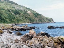
Loughan Bay contains outcrops of the principle lithological variants of the Runabay Head Formation. A series of easily accessible wave washed outcrops contains a range of siliciclastic and green bed strata located structurally on the lower, flat-lying limb of the Altmore Fold. | |
| Introduction: | |
Loughan Bay is situated on the coast of north-east Antrim, about 2km south-south-east of Torr Head and 5km north of Cushendun Bay. Access to the site is over fenced pastureland and by scrambling down steep slopes leading to the foreshore. Exposures along the shoreline and in deeply incised streams at Portnathalin and Portmore include a wide variety of predominantly quartz-feldspar and biotite-rich metasediments with occasional green beds. At the northern end of the site, on the cliffs above the Bay, extensive landslips of chalk (Cretaceous) extend to the foreshore and obscure the Dalradian strata. On the first edition of the one inch to one mile geological map of the area (Ballycastle, Sheet 8 (Geological Survey of Ireland, 1887), the rocks at Loughan Bay were simply classified as "gneiss and limestone and were referred to jointly as "crystalline schists". McCallien (1931) produced the first detailed lithostratigraphic map of north-east Antrim and on it, adopted Dalradian lithostratigraphic nomenclature that was already in use in Scotland. Bailey & McCallien (1934) designated the strata in Loughan Bay as part of the "Pitlochry Schists". This stratigraphy was predicated on a structural interpretation which viewed north-east Antrim as the south-westerly continuation of the regional scale recumbent fold structures already identified on the Cowal Peninsula, SW Scotland (Gunn et al., 1897). The second edition of the Ballycastle Sheet, (Geological Survey of Northern Ireland, 1963) and the accompanying Geological Memoir (Wilson et al., 1966) contained a revised stratigraphy and structural interpretation based on detailed mapping of the Dalradian rocks. A more formal approach to lithostratigraphic nomenclature for the Dalradian of north-east Antrim emerged on the first edition of the Solid Geology Map of Northern Ireland (Geological Survey of Northern Ireland, 1977) and, for the first time, local lithostratigraphic names were given to the principal rock units. The strata at this site were referred to as the Loughan Bay Schists. Arthurs (1976) produced a major revision of the Dalradian stratigraphy of north-east Antrim and defined a new lithostratigraphic framework, see table below. The Loughan Bay Schist were renamed and included as part of the areally more extensive Runabay Head Formation. Although Arthurs' revision was based on reconnaissance mapping, and further detailed work is required in this area, this lithostratigraphy was incorporated in the second edition of the Solid Geology Map of Northern Ireland (Geological Survey of Northern Ireland, 1997). TABLE TO BE ADDED Dalradian stratigraphy and ESCR sites in North-east Co. Antrim. | |
| Description: | |
Above the high water line in Loughan Bay, the Runabay Head Formation is exposed intermittently along the beach and in sea-cliffs from a point 400m S of Crockan Point to the cliffs 400m north-west of Runabay Head. The strata in Loughan Bay have been described in great detail by Wilson et al. (1966). The principle lithologies include quartz schists and psammites, feldspathic grits, dark quartz-biotite schists and green beds. The majority of rocks in Loughan Bay also contain tourmaline and porphyroblastic albite. Strata of the Runabay Head Formation also occur in the stream which enters Loughan Bay about150m north of Portnathalin. From just below the 8m high cliff-line to the foreshore there is almost continuous outcrop of mixed lithologies including quartz-biotite +/- albite schist, striped quartz schist, 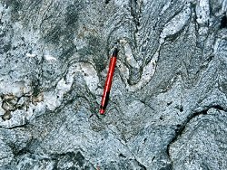 Similar lithologies outcrop along the shore south of Portnathalin where the strata dips at up to 30° to the E. Close to the bottom of this section, the biotite-schists contain numerous pods and boudins of quartz. 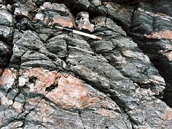 In the small bay called Portnahorna, within Loughan Bay, there are outcrops of distinctive dark green hornblende and biotite schist interbedded with the more characteristic siliciclastic lithologies of the Runabay Formation. 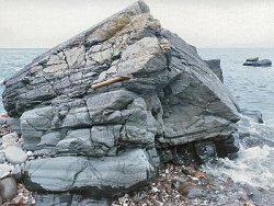 Throughout Loughan Bay there are numerous rounded beach cobbles of a distinctive red quartz-feldspar porphyry. Although this rock is nowhere seen in situ, it is similar to the Cushendun Granite and a number of offshoot dykes which outcrop approximately 5km to the south-west. | |
| Importance: | |
This is a site of national importance. It provides safe access to high quality exposures of a variety of siliciclastic and volcanogenic lithologies typical of the Runabay Head Formation. The site also contains good examples of albite and tourmaline bearing schists. | |
| Interpretation: | |
During Upper Dalradian times, a series of ensialic marine basins developed along the unstable margin of the Laurentian continent. These basins infilled with predominantly siliciclastic turbidite facies sediments (Runabay Head Formation) derived from erosion of the nearby continental landmass. The basin fill also included green bed sediments derived from volcanic sources. In the Dalradian belts of Ireland and Scotland, green beds are now routinely interpreted as admixtures of siliciclastic and basic volcaniclastic sediment (Gunn, 1897; Pickett, 1998) and are believed to have been deposited either directly as ash fall or ash flow tuffs, or were derived as a result of erosion of basic volcanic terranes on the nearby continental margins. Towards the end of Middle Dalradian times (Tayvallich Subgroup, Argyll Group), extension and the break-up of the Laurentian continental margin resulted in crustal thinning and was accompanied by a major upsurge of volcanic activity. This activity persisted well into the Upper Dalradian with contemporaneous volcanic rocks presumably acting as the source of the green bed sediments. During the Caledonian Orogeny, the Dalradian rocks underwent intense deformation. In north-east Antrim, as in Scotland and elsewhere in Ireland, this deformation was complex and polyphase. It resulted in folding with the formation of up to four recognisable fold phases and related cleavages (Arthurs, 1976; Goldring, 1961). Structurally, rocks at Loughan Bay are located on the flat-lying lower limb of the Altmore Anticline which is regarded as the south-westerly continuation into Ireland of the Cowal Anticline in SW Scotland (Gunn et al., 1892; Arthurs, 1976). Deformation was accompanied by relatively low-grade regional metamorphism. Strata at Loughan Bay contain mineral assemblages indicative of metamorphism within the quartz-albite-muscovite- chlorite sub-facies of the Greenschist Facies. | |
| Conclusions: | |
Loughan Bay is an important locality within the context of the Dalradian stratigraphy of north-east Antrim. It offers an unparalleled opportunity for geologists to study high quality, wave-polished outcrops of a wide range of lithologies representative of the Runabay Head Formation. | |
| Notes: | |
For site specific information and references on other Dalradian sites in North-east Antrim see the following sites: Key Site 155 - Benvan Key Site 156 - Escort Port Key Site 157 - Torr Head Key Site 158 - Altmore Burn Key Site 159 - Leckpatrick Point Key Site 160 - Carnaneigh Key Site 162 - Loughareema Channel Key Site 163 - Knocknacarry Bridge Key Site 164 - Cushendun Bay and Rock Port For site specific information and references on other Dalradian sites in the Sperrin Mountains, Londonderry and Tyrone see the following sites: For Central and Southern Sperrin Mountains: Key Site 130 - Butterlope Glen Key Site 131 - Craig Key Site 132 - Mullaghcarbatagh Key Site 133 - Henry's Bridge, Glensass Burn Key Site 134 - Oughtboy Burn Key Site 135 - Garvagh Burn Key Site 136 - Barnes Gap Key Site 137 - Barnes Burn Key Site 138 - Golan Burn Key Site 139 - Glendarragh Burn, Glenlark Key Site 140 - Mountfield Old Quarry Key Site 141 - McNally's Burn, Broughderg For North Sperrin Mountains and Londonderry: Key Site 142 - Letterbrat Quarry Key Site 143 - Banagher Glen Quarry Key Site 144 - Strabane Quarry Key Site 145 - Glenmornan River, Artigarvan Key Site 146 - Balix Hill Key Site 147 - Drain Quarry Key Site 148 - Kildoag Quarry Key Site 149 - Loughermore Mountain Key Site 150 - Burntollet and Tamnymore Wood Key Site 151 - Dog Leap, Limavady Key Site 152 - Kittybane Quarry Key Site 153 - Prehen Quarry Key Site 154 - Creevagh Hill Old Quarry For general information on the Dalradian rocks of Northern Ireland see the following site: Key Site 124 - The Dalradian Rocks of Northern Ireland For general and site specific information on the Pre-Dalradian rocks of Northern Ireland see the following site: Key Site 123 - The Pre-Dalradian Rocks of Northern Ireland For general information and an extensive reference list on the Precambrian of Northern Ireland see the following site: Key Site 122 - An Introduction to the Precambrian of Northern Ireland | |
| Keywords | |
|---|---|
| Minerals: | Horneblende |
| Rocks: | Green beds |
| Access | |
|---|---|
| Approach: | Access to the site is over fenced pastureland and by scrambling down steep slopes leading to the foreshore. |
| Management: | |
Loughan Bay lies along part of the coast of Co Antrim currently under the management of the National Trust. This may have implications for access and for sampling policy at the site. This part of the coast is relatively remote and can only be accessed by crossing fenced pastureland. Consequently visitor numbers are low and likely to remain so. The points of geological interest at Loughan Bay are of a very general nature and can be seen at a number of alternative exposures, consequently there is no need to restrict hammering or sampling although, the National Trust may wish to have some input to this aspect of site management. For the most part this site can be visited in complete safety. However, people visiting more exposed parts of the site directly south-east of Portmore should exercise extreme care. This is an exposed coastline prone to high winds and waves. This can make certain outcrops treacherous in bad weather. | |
| References (7) | |||
|---|---|---|---|
| Arthurs, J.W., 1976a. The geology and metalliferous mineral potential of the Sperrin Mountains area Geological Survey of Northern Ireland Special Report. | |||
| Bailey, E.B. & McCallien, W.J., 1934. The metamorphic rocks of North-east Antrim Transactions of the Royal Society of Edinburgh: Earth Sciences, vol. 58, pp.163-177. | |||
| Golding, D.C., 1961. The relationship of the micro-fabric to the small-scale structures of the Dalradian of north-eastern Antrim Proceedings of the Royal Irish Academy, vol. 61 pt. B, pp.345-367. | |||
| Gunn, W., Clough, C.T. & Hill, J.B., 1897. The Geology of Cowal Memoir of the Geological Survey of Scotland. | |||
| McCallien, W.J., 1931. A contribution to the correlation of the Dalradian rocks of Scotland Geological Magazine, vol. 68, pp.153-175. | |||
| Pickett, E., 1998. An introduction to the Green Beds of the Southern Highland Group of the Scottish Dalradian: previous research and an account of preliminary work carried out in 1997. British Geological Survey Technical Report, numb. WA/97/92. | |||
| Wilson, H.E. & Robbie, J.A., 1966. Geology of the country around Ballycastle. Memoirs of the Geological Survey Northern Ireland. | |||
| Map(s): | GSI (1887). 1:63,360 Geological Sheet 8 (Ballycastle), Dublin, OS for GSI GSNI (1963). 1:63,360 Ballycastle, Northern Ireland Sheet 8, Drift, Southampton, OS for GSNI GSNI (1977). 1:250,000 Northern Ireland, Solid Geology (1st edition), Southampton, OS for IGS GSNI (1997). 1:250,000 Northern Ireland, Solid Geology (2nd edition), BGS, Keyworth, Nottingham | ||
| Record type: | ESCR report | ||
| Entered by: | E M Porter | ||
| Enlander, I., Dempster, M. & Doughty, P., 2026. Loughan Bay, County Antrim, site details. [In] Earth Science Conservation Review. https://www.habitas.org.uk/escr/site.php?item=161. Accessed on 2026-11-06. |
| Previous Site | Next Site |