
| Previous Site | Next Site |
Earth Science Conservation Review
| Knocknacarry Bridge, Cushendun | Antrim |
| Site number: | 163 | ||
| ESCC: | EO | ||
| Locality Type: | Stream section | Status: | ESCR |
| Grid Reference: | D240327 Centroid | ||
| Google maps: | 55.12644,-6.05611 | ||
| County: | Antrim | Council area: | Causeway Coast & Glens Borough Council |
| Period: | Precambrian | ||
| Stages: | Dalradian | ||
| Lithostrat: | Cushendun Granite, Glendun Formation, Granite, Southern Highlands Group | ||
| Site Description | |
|---|---|
 | |
| Highlights: | |
This site contains outcrops of gritty psammite and albite schists typical of the Glendun Formation (Southern Highland Group). The site also lies within the thermal aureole of the Cushendun Granite and there is a widespread development of potash rich pneumatolytic veining with some cordierite porphyroblasts in beds of suitable composition. | |
| Introduction: | |
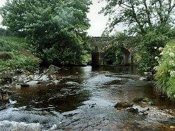
Knocknacarry Bridge spans the River Dun approximately 1km west and upstream from Cushendun. The site includes stream bed outcrop both upstream and downstream of the Bridge. Access is via footstiles and rough steps at the bridge parapet. On the first edition of the one inch to one mile geological map of the area (Cushendall, Sheet 14) (Geological Survey of Ireland, 1884) the rocks at Knocknacarry were simply classified as "gneiss or . . ., mica & hornblende schist" and referred to jointly as "metamorphic rock". McCallien (1931) produced the first detailed lithostratigraphic map of the Dalradian in NE Antrim. In this and subsequent works (Bailey & McCallien, 1934), McCallien adopted the lithostratigraphic nomenclature which was currently used in Scotland. McCallien's stratigraphy was based on a structural interpretation which viewed north-east Antrim as the south-westerly continuation into Ireland of recumbent fold structures already identified on the Cowal Peninsula, SW Scotland (Gunn et al., 1897). Bailey et al. (1934) assigned the strata at Knocknacarry Bridge to the Ben Ledi Grits passing upstream into underlying Pitlochry Schists and indicated that both formations are within the nose of an overturned, tight, downwards-facing structure (is equivalent to the Carrick Castle Fold, Argyll). A more formal approach to lithostratigraphic nomenclature for the Dalradian in north-east Antrim emerged on the first edition of the Solid Geology Map of Northern Ireland (Geological Survey of Northern Ireland, 1977). Here, for the first time, the principal rock units were given local lithostratigraphic names. In this new scheme, the strata at Knocknacarry were referred to as the Glendun Schists. Arthurs (1976) produced the most recent revision of the Dalradian stratigraphy of north-east Antrim and defined a new lithostratigraphic framework, see table below, amending and redefining many of the formations including the Glendun Schists. Although this revision was based on reconnaissance mapping, and further detailed work is required in this area, it was incorporated in the second edition of the Solid Geology Map of Northern Ireland (Geological Survey of Northern Ireland, 1997). TABLE TO BE ADDED Dalradian stratigraphy and ESCR sites in North-east Co. Antrim. | |
| Description: | |
The site encompasses all stream bed outcrops extending for approximately 40m upstream and 30m downstream of Knocknacarry Bridge. The principle lithologies are mid-grey quartz-feldspar psammite and gritty psammite, albite schist and thin interbeds of semi-pelite. Bedding and a bedding-parallel (composite?) cleavage can be seen at various points in the section with dipping consistently at about 30° NE. Upstream from Knocknacarry Bridge, at the top of the section, Bailey et al. (1934) recorded cordierite porphyroblasts which they described as "large outstanding spots". These crystals are rounded (5-10mm dia.) and stand proud of the weathered beddingfoliation surfaces. Cordierite appears to be restricted to the more aluminous semi-pelitic horizons reflecting compositional control in the metamorphic process. At the time of the recent site visit, cordierite was best seen on a large slumped block (2m x 2m x 2m) on the left bank of the river 40m upstream of the bridge. Throughout the site there is abundant evidence of igneous and pneumatolytic veining, reflecting the proximity of the Cushendun Granite whose closest recorded outcrop is less than 1km north of the site. Veining is particularly conspicuous on water worn slabs of well-bedded quartz psammite and gritty psammite directly downstream of Knocknacarry Bridge. These intricately ramifying veins were emplaced late in the geological history of the area and cut across all other bedding and cleavage surfaces. Veins varying from millimetre to centimetre scale most commonly contain quartz, feldspar and biotite. 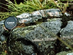 | |
| Importance: | |
The river section at Knocknacarry Bridge contains good exposures of lithologies typical of the Glendun Formation in an area of otherwise poor exposure. It also offers an opportunity to study the thermal metamorphic effects of the Cushendall Granite on the Dalradian country rock. | |
| Interpretation: | |
During Upper Dalradian (late Proterozoic) times, a number of marine sedimentary basins formed along the unstable margin of the Laurentian continent. These basins were infilled and subsided under the weight of the accumulating mainly siliciclastic turbidite sediments derived from the nearby continental landmass to the north-west. During the Caledonian Orogeny the Dalradian rocks in Northern Britain and Ireland were deformed and metamorphosed. In north-east Antrim, as in Scotland and the Sperrin Mountains, underwent complex polyphase deformation which resulted in folding and the formation and up to four recognisable cleavages (Arthurs, 1976; Goldring, 1961). Structurally, this site now lies on the downwards-facing inverted limb of the Altmore Anticline, a structure interpreted as the southerly continuation of the Cowal Anticline in south-west Scotland (Arthurs, 1976). The mineral assemblages found in the rocks at this site are consistent with low-grade regional metamorphism with temperature and pressure conditions within the quartz-albite-muscovite- chlorite sub-facies of the Greenschist Facies. During late Caledonian times, following the main phase of deformation and regional metamorphism of the Dalradian rocks, the Cushendall Granite was emplaced directly to the north of the site. The rocks at Knocknacarry Bridge lie well within the thermal metamorphic aureole of this intrusion as seen by the formation of cordierite in certain compositionally suitable horizons and the widespread presence of pneumatolytic veining throughout the outcrop. | |
| Conclusions: | |
This is an important site with strong local and national significance. A fuller appreciation of the significance of the site must await the resurvey of the Cushendall Sheet which is scheduled by the Geological Survey of Northern Ireland to take place by the year 2000. At present the site offers opportunities to study aspects of local Dalradian stratigraphy (Glendun Formation), structure and the thermal metamorphic effects of the late-Caledonian Cushendun Granite. | |
| Notes: | |
For site specific information and references on other Dalradian sites in North-east Antrim see the following sites: Key Site 155 - Benvan Key Site 156 - Escort Port Key Site 157 - Torr Head Key Site 158 - Altmore Burn Key Site 159 - Leckpatrick Point Key Site 160 - Carnaneigh Key Site 161 - Loughan Bay Key Site 162 - Loughareema Key Site 164 - Cushendun Bay and Rock Port For site specific information and references on other Dalradian sites in the Sperrin Mountains, Londonderry and Tyrone see the following sites: For Central and Southern Sperrin Mountains: Key Site 130 - Butterlope Glen Key Site 131 - Craig Key Site 132 - Mullaghcarbatagh Key Site 133 - Henry's Bridge, Glensass Burn Key Site 134 - Oughtboy Burn Key Site 135 - Garvagh Burn Key Site 136 - Barnes Gap Key Site 137 - Barnes Burn Key Site 138 - Golan Burn Key Site 139 - Glendarragh Burn, Glenlark Key Site 140 - Mountfield Old Quarry Key Site 141 - McNally's Burn, Broughderg For North Sperrin Mountains and Londonderry: Key Site 142 - Letterbrat Quarry Key Site 143 - Banagher Glen Quarry Key Site 144 - Strabane Quarry Key Site 145 - Glenmornan River, Artigarvan Key Site 146 - Balix Hill Key Site 147 - Drain Quarry Key Site 148 - Kildoag Quarry Key Site 149 - Loughermore Mountain Key Site 150 - Burntollet and Tamnymore Wood Key Site 151 - Dog Leap, Limavady Key Site 152 - Kittybane Quarry Key Site 153 - Prehen Quarry Key Site 154 - Creevagh Hill Old Quarry For general information on the Dalradian rocks of Northern Ireland see the following site: Key Site 124 - The Dalradian Rocks of Northern Ireland For general and site specific information on the Pre-Dalradian rocks of Northern Ireland see the following site: Key Site 123 - The Pre-Dalradian Rocks of Northern Ireland For general information and an extensive reference list on the Precambrian of Northern Ireland see the following site: Key Site 122 - An Introduction to the Precambrian of Northern Ireland | |
| Keywords | |
|---|---|
| Minerals: | Cordierite |
| Rocks: | Psammite, Schist |
| Access | |
|---|---|
| Approach: | Access to the river is via foot stiles at the northern end of the Knocknacarry Bridge then across pastureland, on either side of the bridge. |
| Management: | |
This site lies entirely within the bed and banks of the River Dun. Signs at the stiles indicate that this stretch of river is fished by the Glens Angling Club. It is recommended that sampling restrictions should be considered for this site. Some aspects of the geological interest, in particular the occurrence of cordierite and to a lesser extent, good water-washed examples of intrusive granite and pneumatolytic veins, are sufficiently restricted as to warrant the imposition of a hammering ban. | |
| References (7) | |||
|---|---|---|---|
| Arthurs, J.W., 1976a. The geology and metalliferous mineral potential of the Sperrin Mountains area Geological Survey of Northern Ireland Special Report. | |||
| Bailey, E.B. & McCallien, W.J., 1934. The metamorphic rocks of North-east Antrim Transactions of the Royal Society of Edinburgh: Earth Sciences, vol. 58, pp.163-177. | |||
| Barrow, G., 1893. On an intrusion of muscovite-biotite gneiss in the southeastern Highlands of Scotland, and its accompanying metamorphism Quarterly Journal of the Geological Society of London, vol. 49, pp.330-358. | |||
| Golding, D.C., 1961. The relationship of the micro-fabric to the small-scale structures of the Dalradian of north-eastern Antrim Proceedings of the Royal Irish Academy, vol. 61 pt. B, pp.345-367. | |||
| Gunn, W., Clough, C.T. & Hill, J.B., 1897. The Geology of Cowal Memoir of the Geological Survey of Scotland. | |||
| McCallien, W.J., 1931. A contribution to the correlation of the Dalradian rocks of Scotland Geological Magazine, vol. 68, pp.153-175. | |||
| Wilson, H.E. & Robbie, J.A., 1966. Geology of the country around Ballycastle. Memoirs of the Geological Survey Northern Ireland. | |||
| Map(s): | GSI (1884). 1:63,360 Geological Sheet 14 (Cushendall), Dublin, OS for GSI GSNI (1963). 1:63,360 Ballycastle, Northern Ireland Sheet 8, Drift, Southampton, OS for GSNI GSNI (1977). 1:250,000 Northern Ireland, Solid Geology (1st edition), Southampton, OS for IGS GSNI (1997). 1:250,000 Northern Ireland, Solid Geology (2nd edition), BGS, Keyworth, Nottingham | ||
| Record type: | ESCR report | ||
| Entered by: | E M Porter | ||
| Enlander, I., Dempster, M. & Doughty, P., 2026. Knocknacarry Bridge, Cushendun, County Antrim, site details. [In] Earth Science Conservation Review. https://www.habitas.org.uk/escr/site.php?item=163. Accessed on 2026-11-06. |
| Previous Site | Next Site |