
| Previous Site | Next Site |
Earth Science Conservation Review
| Cultra - Permian | Down |
| Site number: | 17 | File Number: | J48 |
| ESCC: | IM | ||
| Locality Type: | Coastal section | Status: | ASSI |
| Grid Reference: | J413810 Centroid | ||
| Google maps: | 54.65775,-5.81046 | ||
| County: | Down | Council area: | Ards & North Down Borough Council |
| Period: | Permian, Carboniferous | ||
| Stages: | Zechstein | ||
| Lithostrat: | Magnesian Limestone, Magnesian Limestone (Durham), Lower, Permian Upper Marls | ||
| Site Description | |
|---|---|
 | |
| Highlights: | |
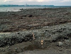
The faulted block of Permian rocks seen on the foreshore at Cultra is the best exposed example of Permian rocks in Ireland. The only other surface outcrop is at Ardtrea, Co. Tyrone, though rocks of this age are known from mines and boreholes elsewhere. | |
| Introduction: | |
The latest years of the Carboniferous period, and probably the early part of the Permo-Trias, were marked in the north of Ireland by intermittent earth-movements, with alternations of erosion and deposition. Newly elevated areas were deeply dissected and debris from the high ground collected in valleys and in front of fresh scarps. In Ulster these debris were coarse breccias, sometimes hundreds of metres thick as in the Newtownards trough, but at Cultra represented by only 1.5m of polymict brockram. The Upper Permian was marked by the widespread transgression of the Bakevellia Sea, so called because of the appearance of the small marine bivalve Bakevellia, and arms of this incursion penetrated parts of eastern Ireland. In this area the first marine deposit was the dolomitic Magnesian Limestone which is correlated with the Lower Magnesian Limestone of County Durham of Zechstein 1 age. The foreshore of the South side of Belfast Lough shows more or less continuous exposure of Lower Carboniferous and Triassic rocks for a distance of over 2km east from Holywood. At Cultra (J413810) a faulted block of Permian rocks rests unconformably on Carboniferous strata. The total thickness of Permian rocks is only about 13m but they occupy the foreshore for about 320m. A basal breccia (Enler Group) of angular fragments of Lower Palaeozoic and Carboniferous rocks in a purple or green sandy matrix, 0.6m to 1.5m thick is overlain by massive yellow dolomite about 8.4m thick. This is overlain by 3m of dull red sandy marls (Permian Upper Marls), the highest beds seen in the succession. It is of interest that the dolomite was quarried by the Norman builders of Carrickfergus Castle, across the lough, and used as quoins and architraves. Permian beds were first recorded from this locality by Bryce (1837), though he confused reddened Carboniferous with Permian; the existence of Permian rocks with diagnostic fossils, Schizodus and Bakevellia, was established by Binney (1855). The area was systematically mapped by Du Noyer in 1867 (Hull et al., 1871) and revised by Lamplugh (1904). Recent resurvey by the Geological Survey of Northern Ireland (Cobbing in Griffith & Wilson, 1982) and discussion of the fossils by Pattison (1970) has confirmed the Lower Magnesian Limestone age of the deposit. | |
| Description: | |
The published account of the Cultra area in the Geological Survey Memoir for one-inch Sheet 29 (1982) takes as its base for the Permian outcrop the Cultra Sewage Works (J414810). This installation is now removed, though part of the outfall is still seen on the foreshore. The Sewage Works Fault can now be located as 30m east from the access ramp to the beach, situated 100m east of the junction of Circular Road and Seafront Road. The fault, with obvious near-vertical Carboniferous strata, marks the eastern end of the Permian. The whole Permian outcrop is heavily encrusted with mussels and the tripartite division into a basal breccia, Magnesian Limestone and Upper Marls, is by no means obvious without much clearance. Furthermore details given in the Memoir lack clarity. In particular the extent of the outcrop as 320m seems to be at least 70m too much. A small-scale diagram of the foreshore shows the Sewage Works Fault to be accompanied by a dolerite dyke, but this is not mentioned in the text nor seen on the foreshore. West from the Sewage Works Fault, the foreshore for over 100m consists of Magnesian Limestone dipping steadily NW at 25 deg. 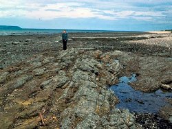 A short distance east of the access steps at the bottom of Circular Road the dolomite is intersected by two converging dykes, both trending approximately NW, the western of which is completely altered to rotten lithomarge (the 'White Trap' of the earlier observers). West of the lithomarged dyke the dip of the beds swings to NNW until they meet, in about 18m, a third dyke along a fault trending NNW and downthrowing to the west. This fault intersects a further dislocation, trending almost east-west. North of this the dolomite continues out to sea, dipping at 10 deg. to the NNW. South is a small syncline in Red Permian marls which extends their outcrop to about 14m, while the underlying Magnesian Limestone is anticlinally folded into a small pericline, with the underlying breccia visible in the core. The dolomite extends southward for about 18m where it passes down into 0.6m of basal breccia, which rests unconformably on the underlying Carboniferous mudstones. Lamplugh et al., (1905) provided a measured section. The extensive fossil collections from Cultra held by the British Geological Survey were examined by Pattison (1970). He recorded Agathammina milioloides, A. pusilla, Calcitornella? minutissima, cf. Cyclogyra sp., cf. Hemigordius sp. and gastropods including cf. Coelostylina? leighi, cf. Coelostylina? obtusa, Glyptospira? helicina, cf. `Loxonema' phillipsi, Naticopsis minima, cf. Dentalium sp., Bakevellia (B.) binneyi, B. (B.) cf. ceratophaga, Liebea squamosa, cf. Nucula? sp., cf. Parallelodon striatus, Permophorus costatus, Schizodus obscurus, and ostrocods, and commented that bivalves and especially internal and external moulds of Bakevellia (B.) binneyi are the most common fossils. | |
| Importance: | |
As the best surface exposure of Permian beds in Ireland this exposure is of major importance to the study of Irish stratigraphy and, at the western extremity of the Permian in Europe, is of international significance. Though the current correlation of these beds with the north of England, and thence with Permian of the whole of Europe, is good, the possibility of fresh developments in palaeontology, especially micropalae- ontology, makes the preservation of this outcrop of importance for the future. | |
| Interpretation: | |
The identification of this small outcrop as Permian has never been in doubt since 1855, but its correlation with the succession in England has been the cause of some controversy. The occurrence of Productus horridus was recorded by Baily (in Hull, 1871) but the specimen has been lost and extensive collecting has never repeated it. In fact the presence of any brachiopods in the Permian of Down or Tyrone is a distinct rarity. However the faunal distribution, with abundant gastropods and bivalves suggests a correlation with the carbonate phase of Zechstein 1, the Lower Magnesian Limestone of northern England. More recent work (Warrington, 1995) on miospores from the Larne No. 2 Borehole confirm a late Permian, i.e. Kazanian to Tatarian age, for the Magnesian Limestone. | |
| Conclusions: | |
These important exposures on a foreshore site are of prime importance, but with a sea-wall and a public roadway behind them, are not at risk, except for possible developments of marinas and boatslips. The nature of the overlooking property, however, makes this unlikely. | |
| Notes: | |
For information on other Permian sites see Key Site 1195 - Ballyrainey Key Site 1196 - Drumarg. For general information on the Permian System in N. Ireland see Key Site 1191 - The Permian System in N. Ireland - Introduction. | |
| Keywords | |
|---|---|
| Rocks: | Breccia, Dolomite, Marl |
| Fossil Groups: | Bivalve, Gastropod, Microfossil |
| Fossil List: | Bakevellia (B.) binneyi , Schizodus obscurus |
| Relations: | Marine sediments |
| Measurements | |||||
|---|---|---|---|---|---|
| Length: | 320 m | Width: | Height: | ||
| Depth: | ~13 m | Area: | |||
| Access | |
|---|---|
| Approach: | From the Sea Front Road. |
| Management: | |
Apart from the active discouragement of foreshore development the site should need little supervision. The relative abundance of small fossils should not require any restriction on student collecting. | |
| Threats: | Building development |
| References (7) | |||
|---|---|---|---|
| Binney, E.W., 1855. On the Permian Beds of north-west England. Memoirs and Proceedings of the Manchester Literary and Philosophical Society, vol. 12, pp.209-69. | |||
| Bryce, J., 1837. On the Magnesian Limestone and associated beds which occur at Holywood in the County of Down. Journal of the Geological Society of Dublin, vol. 1, pp.175-180. | |||
| Griffith, A.E. & Wilson, H.E., 1982. Geology of the country around Carrickfergus and Bangor. Memoir of the Geological Survey of Northern Ireland, Sheet 29 (N. Ireland). | |||
| Hull, E., Warren, J.L. & Leonard, W.B., 1871. Explanatory memoir to accompany sheets 37, 38 and part of 29 including the country around Bangor, Newtownards, Comber and Saintfield in the County of Down. Memoirs of the Geological Survey of Ireland. | |||
| Lamplugh, G., Kilroe, J.R., M’Henry, A., Seymour, H.J., Wright, W.B. & Muff, H.B., 1904. The Geology of the Country Around Belfast. Memoirs of the Geological Survey of Ireland. | |||
| Pattison, J., 1970. A review of marine fossils from the Upper Permian rock of Northern Ireland and north-west England. Bulletins of the Geological Survey of Great Britain, vol. 32, pp.123-165. | |||
| Warrington, G., 1995. The Permian, Triassic and Jurassic in N. Ireland: a palynological study with special reference to the hydrocarbon prospectivity of the Larne-Lough Neagh Basin. numb. GSNI/95/7 Geological Survey of Northern Ireland. | |||
| Map(s): | See the 1:50,000 O.S. Sheet 15 (Belfast); GSNI (1982) Sheet 29. | ||
| Record type: | Environment Serv. GIS, ESCR report | ||
| Entered by: | Crowther, P.R. | ||
| Last updated: | 12 Jun 2004 | ||
| Enlander, I., Dempster, M. & Doughty, P., 2026. Cultra - Permian, County Down, site details. [In] Earth Science Conservation Review. https://www.habitas.org.uk/escr/site.php?item=17. Accessed on 2026-11-06. |
| Previous Site | Next Site |