
| Previous Site | Next Site |
Earth Science Conservation Review
| Cuilcagh Mountain | Fermanagh |
| Site number: | 20 | File Number: | H12 |
| ESCC: | EO | ||
| Locality Type: | Crag, Crags | Status: | PART ASSI |
| Grid Reference: | H123280 Summit | ||
| Google maps: | 54.20128,-7.81151 | ||
| County: | Fermanagh | Council area: | Fermanagh & Omagh District Council |
| Period: | Carboniferous | ||
| Stages: | Namurian, Visean | ||
| Lithostrat: | Bellavally Formation, Briscloonagh Sandstone Formation, Carraun Shale Formation, Dartry Limestone Formation, Dergvone Shale Formation, Glenade Sandstone Formation, Gowlaun Shale, Lackagh Sandstone Formation, Leitrim Group, Meenymore Formation, Tyrone Grou | ||
| Site Description | |
|---|---|
 | |
| Highlights: | |
The Leitrim Group outcrop on Cuilcagh Mountain is the best example of Carboniferous (late Vis‚an early Namurian) sediments in Northern Ireland. It provides excellent opportunities for studying a great variety of sedimentary rocks that were deposited in a wide range of marine, supratidal and deltaic environments. Abundant fossils, in particular goniatites, occur in the rocks. | |
| Introduction: | |
In Northern Ireland the outcrop of the Carboniferous Leitrim Group on Cuilcagh Mountain almost completely exposes about 580m of marine sediments consisting primarily of dark shales and mudstones with sandstones. With the exception of the same sequence of rocks that are poorly exposed in the Doagh Outlier, near Derrygonnelly, in Northern Ireland, Cuilcagh Mountain offers unique sections through the Leitrim Group strata. At many horizons in the succession, goniatites are very common and are the principal means by which the local, regional and national correlation of these rocks is achieved. Goniatite faunas of Vis‚an (Asbian and Brigantian Stages) and Namurian (Pendleian and Arnsbergian Stages) age occur in a wide variety of rock types and in variable states of preservation. Within the Leitrim Group on Cuilcagh Mountain the conformable Vis‚an-Namurian boundary (P2-E1 Zones) is represented by the contact between the Carraun Shale and Dergvone Shale formations. Location: The Cuilcagh Mountains are located in northwest Ireland straddling the international border between the Republic of Ireland (County Cavan) and Northern Ireland (County Fermanagh). The summit of the mountain, which occurs at the southeast end of the almost flat and linear table-top, is 665m (2160ft) above sea level and is followed by the unmarked border that rises to the summit cairn from near Swanlinbar, in the east, and from the northwest end of the mountain top, passes northwards to Belcoo, located between the upper and lower portions of Lough Macnean. The entire outcrop of the Leitrim Group is located in northwest Ireland and covers the separate and isolated upland areas including, in the Republic of Ireland the Lackagh Hills, Slieve Anierin Mountains and Arigna Mountains in Cos. Leitrim and Cavan, and the cross-border area of the Cuilcagh Mountains. Bibliographic Review: The first geological appraisal of the Cuilcagh Mountains was conducted by Padget (1953) who provided a simplified map and stratigraphy consisting of Yoredale Sandstone, Yoredale Shale and Millstone Grit. Although this tripartite division is generalised he recognised virtually all of the main goniatite zones of the lower and upper Bollandian (P1 and P2) of the late Vis‚an and of the Pendleian (E1) Stage of the early Namurian, and identified the position of the Visean-Namurian boundary within his Yoredale Shale unit. Since then the geology of the Leitrim Group in the Southern Ireland sector of the Connaught Coalfield outlier has been described in superb detail by Brandon and Hodson (1984). Their meticulous attention to detail and recognition of minute variations in the lithostratigraphy was supported by exhaustive collecting of the rich and variable goniatite faunas which recognised, for the first time, the presence of Arnsbergian (E2) sedimentary rocks in the Leitrim Group. In 1982 the Geological Survey of N. Ireland resurveyed part of the Cuilcagh Mountains and published the results in the geological map of the Derrygonnelly and Marble Arch area of Co. Fermanagh (1:50,000 Sheet 44/56) in 1991. General Geology: In the type area of the Leitrim Group in the Connaught Coalfield outlier the succession is 520m thick and is divisible into 9 formations and 23 members. On the north side of Cuilcagh Mountain the Group is about 580m thick and only the Bencroy Shale Formation at the top of the succession is absent. Of the myriad members identified by Brandon and Hodson all are present on Cuilcagh Mountain, with the exception of an impersistent sandstone in the Carraun Shale Formation and the Alteen and Shass Shale members of the Gowlaun Shale Formation. Throughout much of this coalfield outlier, strata undulate gently with dips rarely exceeding 10 deg. and faulting is relatively unimportant. In complete contrast, however, the geology of the Leitrim Group on the north side of Cuilcagh Mountain is affected by closely spaced normal faults that dislocate the otherwise 'layer-cake' succession of stratigraphical units and thereby complicate the distribution of lithologies. Consequently, there are no individual sites or stream sections on Cuilcagh Mountain that demonstrate more than a small portion of the complete stratigraphical sequence without interruption or repetition by faulting. The presence of individual members of, for example, the Bellavally Formation are thus often defined at geographically scattered sites on the northern slope of the mountain. The definition of individual members in the stratigraphically higher Carraun Shale and Dergvone Shale formations is somewhat simplified by the occurrence, in most stream sections on the mountain of distinctive lithologies that occur at only one horizon in the Group, such as the Tawnyunshinagh Limestone Member of the Carraun Shale Formation. Many superb exposures covering several members of one or more formations occur in deeply incised gullies, for example, the upper part of the Carraun Shale and lower part of the Dergvone Shale Formation at Altvenagh and Altscraghy. | |
| Description: | |
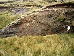
In general the oldest formations of the Leitrim Group on Cuilcagh Mountain crop out at the lowest levels on the mountain and the outcrop of progressively younger stratigraphical units occurs at higher levels. On Cuilcagh Mountain the base of the Leitrim Group, which is coincident with the base of the Meenymore Formation, is disconformable on the top of the underlying Dartry Limestone Formation which represents the highest unit of the Tyrone Group. On the eastern side of the mountain the contact between the Meenymore Formation and the Carn Limestone Member of the Dartry Limestone Formation is exposed in a pothole in Cloghany Townland (H156 310) and in the river just upstream of the pothole at Polliniska (H166 289). On the northern side of the mountain laminated carbonates of the basal Meenymore Formation rest on bioclastic limestones of the Cloghany Member of the Dartry Limestone Formation, and at least 8m of strata of the Carn Limestone Member were eroded hereabouts prior to the deposition of Leitrim Group sediments. On the north face of Trien Mountain the Meenymore Formation is only 2m thick due to attenuation by a major W-E reverse normal fault, and is exposed high in the east bank of the river draining north into Pollasumera. Further west near the border, in Tullygitlagh Townland, the formation is absent and the Dartry Limestone and Glenade Sandstone Formations are juxtaposed by the faulting. Numerous exposures of coarse sandstones of the Glenade Sandstone Formation occur in a broad zone on the northern flank of Numerous exposures of coarse sandstones of the Glenade Sandstone Formation occur in a broad zone on the northern flank of the mountain and on the summit of Trien Mountain. Sections in the Owenbrean River at Legnabrocky and Linduff and in a tributary of the Pollasumera river at Gortmaconnell (H136 309) may represent the contact between the Glenade Sandstone and Meenymore formations. The top of the sandstone is however completely exposed in a unique section in the Sruh Croppa River at Tromogagh (H104 317) where the strata are horizontal and the top of the Glenade Sandstone is exposed in the bed of the river over 130m and the overlying Tullyskeherny Member and most of the Larkfield Shale Member, at the base of the succeeding Bellavally Formation occur in the west bank of the river. Exposures of other members of the Bellavally Formation are distributed haphazardly across the north slope of the mountain, although the coarse-grained and resistant sandstones of the Doobally Member provide a recognisable marker horizon. Throughout the Connaught Coalfield outlier the Glenkeel Member, which overlies the Doobally Sandstone Member, is unfossiliferous. Uniquely on Cuilcagh Mountain, at a partially exposed section at the edge of a plunge pool in the Altvenagh River (H1190 2980), a superb goniatite fauna comprising cf. Arnsbergites falcatus, Beyrichoceratoides truncatum and Goniatites radiatus occurs in the Glenkeel Member and is of Brigantian (P1b) age. A few metres south of the plunge pool is a small outcrop of very fossiliferous blue-grey mudstones and limestones, of the Sheena Shale Member, that contain A. falcatus and Goniatites concentricus. The Corry Member, representing the top of the Bellavally Formation, and the Derreens Limestone Member, at the base of the succeeding Carraun Shale Formation, are clearly exposed at three localities on the mountain. By far the most extensive outcrop is in the Sruh Croppa River (H098 307) at the confluence of two major tributaries, 1.06km NNE of Cuilcagh Gap. 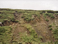 In the middle of the Carraun Shale Formation throughout the Connaught Coalfield outlier is the Tawnyunshinagh Limestone Member. On Cuilcagh Mountain this is 1.15m thick and consists of finely laminated and cumulate stromatolitic limestones, algal chip breccias and a basal layer of reworked, eccentric, spherical clasts of cumulate stromatolite up to 2.5cm diameter. The limestone is unfossiliferous but it separates a fossiliferous lower section of the Carraun Shale Formation from succeeding, relatively unfossiliferous, ferruginous shales above. Three limestone beds occur in the upper part of the Carraun Shale, each containing a distinctive goniatite assemblage. The lowest limestone is the Ardvarney Limestone Member (P1d) which contains abundant Neoglyphioceras; the shales intervening between this bed and the Sranagross Member (P2b) are 5m thick and contain abundant Sudeticeras, Neoglyphioceras granosum and N. subcircularis of P2a-b age. This latter member consists of about 0.2m of very shaley, dolomitic limestone and is separated from the Camderry Member, the highest member in the Carraun Shale Formation, by about 6m of mudstones and shales. The Camderry Member on Cuilcagh Mountain contains carbonate bullions with solid specimens of the P2c goniatites Girtyoceras waitei and Lyrogoniatites georgiensis. Based on the goniatite faunas in this sequence, the top of the Carraun Shale Formation, and the position of the Visean-Namurian boundary, is located 6.5m above the Camderry Member, at the top of a dolomitic limestone 0.12m thick, representing the lowest of three shaley limestones at this level. The upper part of the Carraun Shale and lower part of the Dergvone Shale, up to the Killooman Shale Member (about 70m above the formation base) are exposed in deeply incised gullies located in the headwaters of northward-draining streams at Altvenagh and Altscraghy and in the Sruh Croppa River. The 5 lowest shale members of the Dergvone Shale Formation, namely the Gubaveeny, Black Mountain, Tullyclevaun, Tonlegee and Killooman Members are all exposed in the superb section at Altvenagh (H120 293). Index goniatite taxa of all three subzones of the Pendleian Stage (basal Namurian) occur in these members, in particular the first appearance of the eumorphoceratids Cousteauceras rota and Edmooroceras pseudocoronula and the distinctive and diagnostic Cravenoceras leion which typifies the lower part of the Gubaveeny Shale Member and are characteristic of the E1a Subzone. These species, with the exception of C. leion, are associated with Edmooroceras medusa, a form that is restricted to the top 2m of harder calcareous mudstone, the 'medusa beds', at the top of this member. The Tullyclevaun Shale Member also contains the E1a forms E. pseudocoronula and C. rota but the presence of Tumulites pseudobilinguis in the Tonlegee Shale Member is indicative of the E1b Subzone. Although the fauna of the highest marine band, the Killooman Shale Member, is dominated by bivalves, the presence of the goniatite Cravenoceras malhamense indicates the E1c Subzone. The Lacoon Sandstone Member is located about 30m below the top of the Dergvone Shale Formation and consists of about 5m of thinly bedded sandstones, siltstones and shales. Associated sedimentary structures include parallel and cross-laminations, convolute bedding, ripple marks and directional flute marks and groove casts. The best section of these strata is in the west bank of the unnamed gully (H116 292) some 530m east of Lough Atona. The Briscloonagh Sandstone, Gowlaun Shale and Lackagh Sandstone formations are only exposed in the vertical cliffs and precipitous slopes that fringe the flat summit and reach their maximum development at the southeast end of the mountain between Lough Atona and the summit cairn. The horizontally ribbed and vertically stepped appearance of the lower slopes may be attributed to the interbedded sandstones, siltstones and shales of the Briscloonagh Formation. The outcrop of the overlying Gowlaun Shale Formation is confined to the cliff face located to the southeast of Cuilcagh Gap; northwest of the Gap this formation is excised by faults that lie parallel to the cliff edge and juxtapose sandstones of the Briscloonagh and Lackagh formations. The maximum thickness of the Gowlaun Shale is exposed at the southeast end of the summit ridge where its base conformably succeeds massive sandstones at the top of the Briscloonagh Formation and the top is marked by the gradational entry of sandstones of the Lackagh Formation. Despite the less steeply inclined nature of the hillside underlain by the shales, exposures are rare and only fragmentary specimens of the E2a-b goniatite Eumorphoceras bisulcatum were found near the formation base. The upper cliff line forming the crest of the summit ridge fringes the entire northeast side of the mountain and is formed exclusively of massive sandstones of the Lackagh Formation. The probability that the coarse sandstones of the Lackagh Formation were deposited in a proximal location on a delta complex is further supported by the occurrence, in the cliff line forming the backdrop to Lough Atona, of a palaeofluvial channel that originates at an horizon some 10m above the formation base and erodes through the Gowlaun Shale to a level about 5m above the base of the shale. Severe compaction of the channel-fill sandstones has resulted in the oversteepening and overturning of bedding on the west side of the feature. | |
| Interpretation: | |
The evolution of the sedimentary basin in which the Leitrim Group was deposited reflects a complex history of interactive processes. In particular the sediments reflect extreme variations in water depth and salinity, but more subtle changes in lithology indicate the transitory influence of faulting, firstly within the basin and, secondly along the margins of surrounding land areas from where the sedimentary detritus was derived. Towards the base of the Group the Meenymore and Bellavally Formations reflect deposition in shallow water. Both formations are characterised by the occurrence of marine bands, haphazardly in the former because of the influence of contemporaneous faulting and rhythmically in the latter, due to eustatic control of marine transgressions and regressions. Sandstones of the Glenade Formation were deposited in a delta. Regardless of its overall shape during sediment accumulation, by the end of deposition of these coarse clastic sediments, the top of the delta was represented by an almost horizontal surface onto which the rhythmic sediments of the Bellavally were deposited in a regionally regular and predictable sequence. The interface between the proximal part of the delta and the land area to the north was represented by an active fault line that moved constantly throughout accumulation of the clastic sedimentary wedge. Succeeding shales of the Carraun and Dergvone formations illustrate a change from shallow oxygenated water, with a rich benthos, below the Tawnyunshinagh Limestone Member, to deeper water in which anoxic, reducing seabed conditions severely limited the benthic fauna that could survive. Thin marine bands such as the Gubaveeny, Tonlagee and Tullyclevaun Members represent periods during which the oxygen levels rose and the seabed was recolonised. Sandstone units near the top of the Group reflect clastic deposition either on the distal slope of a delta e.g. the Lacoon Sandstone Member and lower part of the Briscloonagh Sandstone Formation or in a more proximal location, close to the sediment source such as the Lackagh Sandstone Formation with its magnificently preserved fluvial palaeochannel complex. | |
| Conclusions: | |
In Northern Ireland there are very few exposures of Carboniferous strata of late Visean-early Namurian age that display such a wide variety of lithologies and fossil assemblages as are found on Cuilcagh Mountain. The numerous clean sections provide outstanding examples on which to base the principles of, and on which to demonstrate the interaction between litho- and biostratigraphy. Whilst so many other Carboniferous sections in N. Ireland show evidence of both local and regional tectonism or eustasy, the Leitrim Group outcrop in northwest Ireland, of which Cuilcagh Mountain is but a small part, is a prime example of sedimentary rocks which were deposited in a relatively stable depositional basin whose subsidence resulted, almost solely, from the effects of thermal subsidence. Because of the accurate biostratigraphical control offered by the rapidly evolving goniatite faunas that occur in the Leitrim Group it is possible to trace individual lithological members, in particular beds of limestone between 0.15m and 1.2m thick, over an area of some 1400km2. Such persistence of individual lithological units, that occur at virtually all levels throughout the Leitrim Group with the exception only of the basal Meenymore Formation and succeeding Glenade Sandstone Formation, is clear testimony to the relative stability of the depositional basin, the distant and low-lying nature of the sediment source areas and the virtual absence of tectonic activity, in particular of faulting, over a 7-9 million year period between the latest Asbian and mid-Arnsbergian times. | |
| Notes: | |
For information on other sites in Subarea-1 see; Key Site 1174 - Subarea-1; Derrygonnelly-Marble Arch-Cuilcagh. | |
| Keywords | |
|---|---|
| Rocks: | Limestone, Mudstone, Shale |
| Fossil Groups: | Coral, Goniatite |
| Fossil List: | Beyrichoceratoides truncatum , Eumorphoceras bisulcatum, Girtyoceras waitei , Goniatites concentricus , Goniatites radiatus , Lyrogoniatites georgiensis , Neoglyphioceras granosum , Neoglyphioceras subcircularis |
| Relations: | Marine sediments |
| Access | |
|---|---|
| Management: | |
Cuilcagh Mountain comprises an extensive area of upland peat bog in a part of Northern Ireland with higher than average rainfall. No arable farming occurs on the mountain and land use practices are largely confined to pasturing of sheep, and cattle on lower slopes. This activity poses no obvious threat to the mountain habitats. A much more serious threat to the mountain relates to the problem of drainage of the peat bog on the gently inclined northern slopes which will, potentially, lead to mechanised cutting of the turf for fuel purposes. Peat bog is drying out on a massive scale leading to enhanced run-off, more frequent flooding of rivers and the Marble Arch cave system, and enhanced erosion of the peat bog and till on steep slopes. In the past 5 years the incidence of bog bursts has increased enormously and on any visit to the mountain fresh examples are always recognisable. This may or may not be due to the artificial drainage of the peat bog on lower slopes. | |
| Threats: | Deterioration of the peat bog on the N slopes; enhanced erosion. |
| Uses | |
| Uses: | Sheep and cattle pasturing occurs on lower slopes. |
| References (2) | |||
|---|---|---|---|
| Brandon, A. & Hodson, F., 1984. Stratigraphy and Palaeontology of the late Visean and early Namurian rocks of north-east Connaught. Special Papers of the Geological Survey of Ireland, numb. 6. | |||
| Padget, P., 1953. The stratigraphy of Cuilcagh, Ireland. Geological Magazine, vol. 90, pp.17-26. | |||
| Map(s): | See 1:50,000 O.S. Sheet 26 (Lough Allen); GSNI (1991) 1:50,000 Sheet 44/56 (Derrygonnelly and Marble Arch). | ||
| Record type: | Environment Serv. GIS, ESCR report | ||
| Entered by: | Crowther, P.R. | ||
| Last updated: | 12 Jun 2004 | ||
| Enlander, I., Dempster, M. & Doughty, P., 2026. Cuilcagh Mountain, County Fermanagh, site details. [In] Earth Science Conservation Review. https://www.habitas.org.uk/escr/site.php?item=20. Accessed on 2026-11-06. |
| Previous Site | Next Site |