
| Previous Site | Next Site |
Earth Science Conservation Review
| Giant's Grave section | Fermanagh |
| Site number: | 219 | File Number: | H17 |
| ESCC: | EO | ||
| Locality Type: | Stream section | Status: | ESCR |
| Grid Reference: | H191731 Centroid | ||
| Google maps: | 54.60622,-7.70441 | ||
| County: | Fermanagh | Council area: | Fermanagh & Omagh District Council |
| Period: | Carboniferous | ||
| Stages: | Chadian, Visean | ||
| Lithostrat: | Bin Mountain Sandstone Formation, Claragh Sandstone Formation, Termon River Limestone Formation, Tyrone Group | ||
| Site Description | |
|---|---|
 | |
| Highlights: | |
This is by far the most continuous and best exposed section in the Termon River Limestone Formation. The contacts at the base of the formation with the underlying Claragh Sandstone Formation and at the top, with the succeeding Bin Mountain Sandstone Formation are exposed. | |
| Description: | |
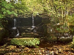
At the north end of the stream section, just west of its confluence with the Termon River (H1889 7320) is exposed the lower contact of the formation. The basal bed of the Termon River Formation is 0.51m thick and consists of dark grey-blue medium- grained, bioclastic sandy packstone with the dayclad alga Koninckopora sp. (monolaminar) and the following foraminifera: Bessiella legrandi Brunsia spirillinoides B. sygmoidalis Dainella sp. Endospiroplectammina cf. venusta Endothyra sp. Palaeospiroplectammina mellina Septabrunsiina sp. Spinobrunsiina sp. This microbiota is of Chadian age. The top 2m of strata of the underlying Claragh Sandstone Formation are exposed in the river bed and north bank of the Termon River at this locality and consist of alternating fine-grained sandstones, highly bioturbated siltstones and grey-blue mudstones. Coarser-grained sandstones form the waterfalls at this confluence point and very coarse-grained arkose, typical of the formation, are exposed in the higher ground just north of the Termon River. Scattered, discontinuous outcrops of the Termon River Limestone Formation occur in the lower (northern) part of the stream course. This contrasts with the southern part of the section where almost 24m of strata are completely exposed between two sets of waterfalls. The lowest 18m of strata are located stratigraphically at the top of the Termon River Limestone Formation. They consist primarily of thin to very thick (more than 1m) blue-grey packstones containing micritised bioclasts, limestone intraclasts, radial-spar ooliths, coated grains, peloids and oncolites. The limestones are interbedded with thin calcareous dark grey silty shales. A sparse macrofauna occurs in the limestones and is frequently silicified. Specimens of gastropods, nautiloids, crinoid ossicles are common with occasional athyrid, rhynchonellid and spiriferid brachiopods. Corals are, however, much less common and only occur in limestones located between 7.7 and 8.7m below the top of the formation. Taxa recorded include: Dorlodotia pseudovermiculare Haplolasma subibicinum Palaeosmilia murchisoni (thin septa) Siphonophyllia sp. Syringopora sp. Colonies of D. pseudovermiculare only occur in one 0.2m thick limestone bed. This is a blue-grey fine-grained, sandy packstone that also contains a poor microbiota including the foraminifera: Brunsia sigmoidalis Earlandia sp. Endothyranopsis ex. gr. crassa Eoparastaffella sp. Globoendothyra sp. Mediocris sp. Priscella sp. On the basis of the presence of Eoparastaffella and the lack of archaediscids this assemblage is of late Chadian age. The sharp contact between the top of the Termon River Limestone and the base of the succeeding Bin Mountain Sandstone occurs at the base of the upper (most southerly) waterfalls and is marked by the change to very sandy limestones and very calcareous sandstones (Photographs 40 and 41). The upper waterfalls are formed entirely of some 3m of the basal beds of the Bin Mountain Sandstone Formation. One bed of very sandy limestone just below the top of the falls is crammed with specimens of the brachiopod Linoprotonia hemisphaerica and a microbiota of late Chadian age include monolaminar and bilaminar Koninckopora and a restricted fauna of foraminifera which is lacking archaediscids. | |
| Interpretation: | |
The sedimentary rocks of the Claragh Sandstone, Termon River Limestone and Bin Mountain Sandstone formations exposed in the Giant's Grave section were all deposited in shallow water. The fine clastic sediments at the top of the Claragh Sandstone are bioturbated delta front deposits that abruptly changed to a shallow water carbonate shelf environment, rich in oncolites and coated grains, in which were deposited the limestones of the Termon River Formation. Although undoubtedly marine, the environment did not support a fully marine benthos and few elements of the late Chadian communities colonised the sea bed. The one exception is the colonial coral Dorlodotia pseudovermiculare which appears to have thrived in this environment; the same cannot be said for solitary corals and brachiopods which occur rarely and usually as small or stunted specimens. The introduction of large quantities of coarse sand represents the abrupt change to the sediments of the Bin Mountain Sandstone Formation. These were also deposited in shallow water, as indicated by the presence of Arenicolites and Skolithos burrows and by the ubiquitous presence of isolated ooliths, in the sandstones, or of thin oolitic limestones. | |
| Conclusions: | |
The Giant's Grave section exposes a thick part of the Claragh Sandstone, Termon River Limestone and Bin Mountain Sandstone formations and is the stratotype for the Termon River Limestone Formation. | |
| Notes: | |
For information on other sites in Subarea-3 see; Key Site 1176 - Subarea-3; Kesh-Omagh. | |
| Keywords | |
|---|---|
| Rocks: | Limestone, Mudstone, Sand, Sandstone, Siltstone |
| Fossil Groups: | Brachiopod, Coral, Crinoid, Foraminifera, Gastropod, Nautiloid |
| Fossil List: | Endothyra sp. , Koninckopora sp. (monolaminar) |
| Relations: | Marine sediments |
| Access | |
|---|---|
| Approach: | Between Gortnaree and Tawnydorragh townlands, 9.3km NNE of Kesh. |
| Record type: | ESCR report | ||
| Entered by: | Crowther, P.R. | ||
| Last updated: | 6 Jun 2005 | ||
| Enlander, I., Dempster, M. & Doughty, P., 2026. Giant's Grave section, County Fermanagh, site details. [In] Earth Science Conservation Review. https://www.habitas.org.uk/escr/site.php?item=219. Accessed on 2026-11-06. |
| Previous Site | Next Site |