
| Previous Site | Next Site |
Earth Science Conservation Review
| Red Arch, north of Waterfoot | Antrim |
| Site number: | 312 | File Number: | D22 |
| ESCC: | EF | ||
| Locality Type: | Coastal section | Status: | ESCR |
| Grid Reference: | D24352630 Centroid | ||
| Google maps: | 55.06891,-6.05421 | ||
| County: | Antrim | Council area: | Causeway Coast & Glens Borough Council |
| Period: | Devonian | ||
| Stages: | Upper Devonian | ||
| Lithostrat: | Red Arch Formation | ||
| Site Description | |
|---|---|
 | |
| Description: | |
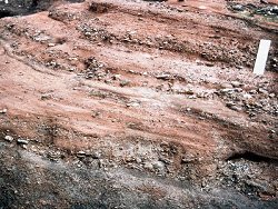
Unit 3 sediments of the Red Arch Formation consist mainly of matrix-supported, salmon-pink pebbly sandstones and thin beds of small imbricated pebbles. Cross-stratification is characteristic of this unit which was probably deposited in a streamflood environment with low gravel bars. The conformable contact between Units 3 and 4 is poorly exposed and the massive structureless conglomerates of Unit 4 are only exposed in one small area about 75m north of the Red Arch. | |
| Notes: | |
For general information and reference list on the Red Arch Formation see Key Site 1148 - Red Arch Formation; Cushendall to Red Arch, Glenariff. For general information and reference list on the Devonian System in N. Ireland see Key Site 1147 - The Devonian System in N. Ireland - Introduction. | |
| Keywords | |
|---|---|
| Rocks: | Conglomerate, Sand, Sandstone |
| Structures: | cross-bedding, massive |
| Map(s): | See the 1:50,000 O.S. Sheet 5 (Ballycastle). | ||
| Record type: | Environment Serv. GIS, ESCR report | ||
| Entered by: | Doughty, P.J. | ||
| Enlander, I., Dempster, M. & Doughty, P., 2026. Red Arch, north of Waterfoot, County Antrim, site details. [In] Earth Science Conservation Review. https://www.habitas.org.uk/escr/site.php?item=312. Accessed on 2026-11-08. |
| Previous Site | Next Site |