
| Previous Site | Next Site |
Earth Science Conservation Review
| Rylagh Burn, near Omagh | Tyrone |
| Site number: | 522 | ||
| ESCC: | EO | ||
| Locality Type: | Stream section | Status: | ESCR |
| Grid Reference: | H462780 Approximate | ||
| Google maps: | 54.64848,-7.2843 | ||
| County: | Tyrone | Council area: | Fermanagh & Omagh District Council |
| Period: | Carboniferous, Precambrian | ||
| Lithostrat: | Glengawna Formation | ||
| Site Description | |
|---|---|
 | |
| Highlights: | |
Outcrops of arsenopyrite-bearing quartz veins, one offset by a fault, and of fault gouge. | |
| Introduction: | |
The Rylagh - Erganagh area is located c.5km north of Omagh, c.1km east of the B48 road to Gortin. Auriferous vein mineralization was discovered as boulders and stream outcrops in this area by Ennex International Ltd in the mid-1980s. More recently, these outcrops were studied and sampled as part of a DED-funded joint industry-university study of gold metallogeny in northwest Northern Ireland (Earls et al., 1996). This study demonstrated that the Rylagh Burn exposures show structural features that are critical to the interpretation of the metallogenic history of the Omagh mineralized belt. As such the site is complementary to Curraghinalt (Key Site 521 - Curraghinalt Burn) and Cavanacaw (Key Site 561 - Creevan Burn, Cavanacaw). An unusual feature of the Rylagh Burn veins is the presence of arsenopyrite. | |
| Description: | |
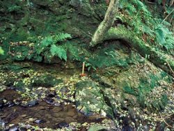
In the Rylagh Burn at NGR 246351E, 378030N a gold-bearing north-south trending quartz vein 0.5m wide dips steeply west and occurs in a coplanar sinistral and top down to the west transtensional shear zone. This is cut by a low-angle fault associated with ESE slickensides and top to the ESE shear sense and the upper part of the vein is translated some 8m to the ESE. The flat-lying fault has an undulating form with periodic dip reversals and the section adjacent to the steep vein in the footwall is extensional and space there has been filled by a flat-lying wedge-shaped quartz vein which is also mineralized. Elsewhere in Rylagh Burn, mineralization occurs in similar steep north-south veins or else in north-south extensional shear zones associated with intense scaly fabrics and sericitic alteration of the host schists (Glengawna Formation). In two such situations, low-angle undulating faults are seen and the high angle structures terminate downwards into them. Another exposure of quartz vein and associated fault gouge is located due north of the Y-junction on Rylagh Road. Chemical analysis (Earls et al., 1996) showed that this gouge contains 1% arsenic, probably derived from arsenopyrite which was observed in the adjacent quartz vein. A third vein located 70m downstream trends east-west and comprises dark-coloured quartz cross-cutting white quartz, a similar relationship to the vein mineralization seen at Curraghinalt. The dark coloured quartz contains fine-grained pyrite, galena and arsenopyrite. Paragenetically late dolomite and barite are also present in this vein. | |
| Importance: | |
Rylagh is a significant site in regional metallogenesis, and is complimentary to sites at Curraghinalt (Key Site 521) and the Cavanacaw gold mine. It is of interest for the occurrence of arsenopyrite, and for illustrating the structural history of the Omagh area. | |
| Interpretation: | |
According to Earls et al. (1996), the form of the low-angle faults in Rylagh Burn is identical to that at Curraghinalt and it is logical to correlate the two. Gouges from the steep faults give K-Ar model ages which are Variscan. Earls et al. (1996) and Parnell et al. (2000) suggest that the north-south orientation of the steep extensional shear zones and veins reflects the orientation of the major crustal lineament which runs through this area (the Omagh Lineament). This lineament is significant as (a) a siting control on mineralization and (b) as a control on the orientation of the mineralized veins. The evidence is; (i) the occurrence of gold and arsenic anomalies from Cavanacaw-Creevan Burn-Cornavarrow NNE in a broad zone through Rylagh-Erganagh to Balix Hill and beyond and (ii) the NNE-SSW or north-south orientation of mineralized veins and mineralized gouges in steep shear zones in the southern part of this zone. During the Variscan, general southeast overthrusting took place on the Omagh-Castle Archdale Thrust. In the hangingwall, space was created in steep extensional and sinistral north-south shear zones, controlled in orientation by the Omagh Lineament. However, like Curraghinalt, these extensional structures were linked kinematically to low-angle thrust structures, both in the Dalradian hangingwall and at the thrust front itself on the southern side of the Lack inlier. The maximum age of auriferous veins of the general north-south trend (e.g. Cavanacaw, Rylagh) is unknown but cathodoluminescence, fluid inclusion and stable isotope studies suggest that they are formed from the same fluids as the northwest-trending Curraghinalt veins. | |
| Conclusions: | |
The principal feature in Rylagh Burn is an excellent exposure of a 1m-thick, auriferous and arsenopyrite-bearing quartz vein which is offset by a sub-horizontal fault. Other veins and faults occur within 250m downstream and in the adjacent Erganagh Burn. The Rylagh Burn site would be a valuable educational resource if access from the nearby road were improved. | |
| Notes: | |
This site is complementary to Curraghinalt (Key Site 521 - Curraghinalt Burn) and Cavanacaw (Key Site 561 - Creevan Burn, Cavanacaw). | |
| Keywords | |
|---|---|
| Minerals: | Arsenopyrite, Gold, Pyrite, Quartz |
| Rocks: | Schist |
| Structures: | fault, hydrothermal vein, fault gouge |
| Measurements | |||||
|---|---|---|---|---|---|
| Length: | Width: | 0.5-1.0m | Height: | ||
| Depth: | Area: | ||||
| Access | |
|---|---|
| Management: | |
Access is the main problem due to steep sides of the river and fallen trees blocking the route. Currently this renders the locality unsuitable for educational visits. Measures that would enable such visits should be considered, in consultation with the landowners. These might include construction of a gate through the overgrown hedge and a ramp on the south bank of Rylagh Burn, together with periodical clearance of fallen trees and branches between the access point and the outcrops. | |
| Uses | |
| Uses: | The immediate vicinity of the Rylagh Burn site comprises unmanaged deciduous woodland. This is surrounded by arable and pasture farmland. There are dwellings within 500m. |
| Map(s): | OSNI 1:50,000 sheet 13. | ||
| Record type: | ESCR report | Recorded by: | R. Nawaz and N.R. Moles |
| Entered by: | E M Porter | ||
| Last updated: | 07 MAY 68 | ||
| Enlander, I., Dempster, M. & Doughty, P., 2026. Rylagh Burn, near Omagh, County Tyrone, site details. [In] Earth Science Conservation Review. https://www.habitas.org.uk/escr/site.php?item=522. Accessed on 2026-11-08. |
| Previous Site | Next Site |