
| Previous Site | Next Site |
Earth Science Conservation Review
| Clinty Quarry - Mineralogy | Antrim |
| Site number: | 526 | ||
| ESCC: | EA | ||
| Locality Type: | Quarry (working) | Status: | ESCR |
| Grid Reference: | D101071 Centroid | ||
| Google maps: | 54.89987,-6.28375 | ||
| County: | Antrim | Council area: | Mid & East Antrim Borough Council |
| Period: | Tertiary | ||
| Stages: | Eocene | ||
| Lithostrat: | Interbasaltic Formation, Upper Basalt Formation | ||
| Site Description | |
|---|---|
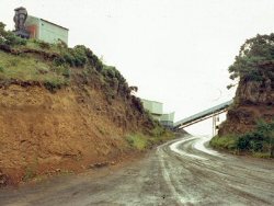 | |
| Highlights: | |
An active quarry in Tertiary basalt with zeolite minerals and Interbasaltic Beds of bauxite, laterite and lignite. | |
| Introduction: | |
Clinty Quarry, located 4km north of Ballymena town centre, is a working basalt quarry operated by Robert Stevenson and Brothers Ltd. Also on the site is an industrial plant that produces ferrous aluminium sulphate solution (FAS) using lateritic bauxite from the quarry. Clinty Chemicals Ltd. market FAS as a flocculating agent and water purifier. Access to the quarry must be arranged through Stevenson’s: in previous years the managers have permitted educational and research visits. The quarry affords excellent exposures of the Interbasaltic Bed including a section with pisolitic ironstone and quarried sections showing profiles through the Beds and residual core-stones of basalt. Amygdaloidal basalts containing zeolites and calcite occur within the basalt quarry, and intermittently laterites with lignite are exposed. | |
| Description: | |
There are three areas of interest at Clinty Quarry: (a) rock exposures close to the site offices; (b) the bauxite quarry; and (c) the basalt quarry. Area (a) is located within the site c.60m north of the main office (see map). It comprises an inclined road-cut and an adjacent 3m-high, 15m long cliff section exposing laterites of the Interbasaltic Bed and an overlying lava flow of the Upper Basalt Formation. 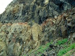 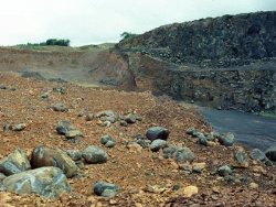 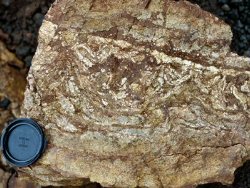 Area (c) is the main basalt quarry, which in 1997 was active in the northern section while the southern workings were disused and had become overgrown. The quarry is worked in the 15-20m thick, massive lower flow of the Upper Basalt Formation, and zeolite-bearing amygdaloidal material is fairly scarce. Saponite-filled pipe amygdales were noted in loose material, and towards the southern end of the active area, amygdaloidal basalt containing zeolites and calcite. 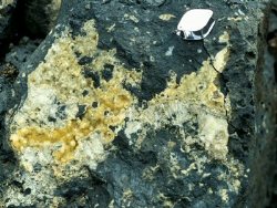 | |
| Importance: | |
Features seen here are not unique in Northern Ireland: similar features occur on the currently inaccessible cliff path east of the Giant’s Causeway. However, the Clinty Quarry site is worthy of designation for several reasons: (a) its accessibility; (b) the variety of features that can be seen in a small area; and (c) the economic use of the laterite which is of educational value as this links geology, chemistry and environmental sciences. | |
| Interpretation: | |
The vertical sections through the Interbasaltic Bed allow rock weathering and laterite development to be demonstrated. Comparisons can be made with regions of present-day lateritic soil development such as Australia, where pisoliths commonly form the ground surface and are underlain by laterites and deeply-weathered rock. Hill et al. (2000) report recent research on the Eocene laterites of Northern Ireland and conclude that a sub-tropical climate with high rainfall resulted in formation of the Interbasaltic Bed over a relatively short period of time (1-2 million years). This contrasts with the laterites in Australia and other relatively arid countries which are thought to have developed over a time period of at least 50-60 million years. | |
| Conclusions: | |
Clinty Quarry is a high priority site for designation on the basis of mineralogical, palaeo-environmental and economic interest. | |
| Notes: | |
See also SLNCI Key Site 712 - Clinty Quarry. | |
| Keywords | |
|---|---|
| Minerals: | Analcime, Calcite, Chabazite, Gyrolite, Natrolite, Saponite, Thomsonite, Zeolites, Mesolite, Apophyllite |
| Rocks: | Amydaloidal Basalt, Basalt, Bauxite, Ironstone, Laterite, Lignite |
| Structures: | amygdales, pipe amygdaloid |
| Paleoenv: | subtropical |
| Access | |
|---|---|
| Management: | |
The exposures in area (a) are relatively secure in that active quarrying is unlikely to occur in this area, but the quarry management should be aware of their interest to ensure that the outcrops are conserved. Active extraction continually refreshes exposures in the quarry, however should extraction of laterite in area (b) cease, provision should be made to retain a representative section for future access. | |
| Uses | |
| Uses: | The site is an active quarry, and part of the area of interest comprises exposures in a now inactive area of quarry. The surrounding area is farmland and forestry. |
| Map(s): | OSNI 1:50,000 sheet 9. | ||
| Record type: | ESCR report | Recorded by: | R. Nawaz and N.R. Moles |
| Entered by: | E M Porter | ||
| Last updated: | 07 MAY 68 | ||
| Enlander, I., Dempster, M. & Doughty, P., 2026. Clinty Quarry - Mineralogy, County Antrim, site details. [In] Earth Science Conservation Review. https://www.habitas.org.uk/escr/site.php?item=526. Accessed on 2026-11-06. |
| Previous Site | Next Site |