
| Previous Site | Next Site |
Earth Science Conservation Review
| Keenaghan - Mineralogy | Fermanagh |
| Site number: | 543 | ||
| ESCC: | EO | ||
| Locality Type: | Crags, Road cutting | Status: | local interest |
| Grid Reference: | G982597 Centroid | ||
| Google maps: | 54.4862,-8.02775 | ||
| County: | Fermanagh | Council area: | Fermanagh & Omagh District Council |
| Lithostrat: | Ballyshannon Limestone Formation | ||
| Site Description | |
|---|---|
 | |
| Highlights: | |
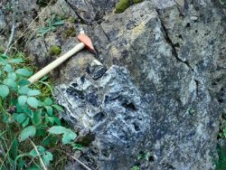
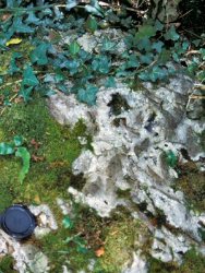
Dolomitized and silicified limestone with crystals of quartz, dolomite, calcite and rare copper sulphides. | |
| Introduction: | |
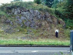
This locality comprises roadside exposures 3.5km east of Belleek on the A47 road to Kesh. The exposures are located on the inside bend of a sharp corner where the road swings south through a topographic ridge formed by silicified and dolomitized limestones of the Ballyshannon Limestone Formation. At this locality, Waulsortian reef limestones are indicated on the GSNI 1:250,000 Geological Map of Northern Ireland. | |
| Description: | |
  | |
| Importance: | |
This is an easily accessible site (although cars must be parked away from the dangerous bend), which illustrates hydrothermal alteration of limestone and the crystallisation of dolomite, quartz and traces of copper-iron sulphides. It has been visited for educational purposes by Queen’s University students and as part of a conference excursion. | |
| Notes: | |
See also Key Site 218 - Keenaghan Lough. | |
| Keywords | |
|---|---|
| Minerals: | Calcite, Chalcopyrite, Dolomite, Pyrite, Quartz, Bornite |
| Rocks: | Dolomite, Limestone |
| Structures: | vugh |
| Access | |
|---|---|
| Approach: | This easily accessible locality comprises roadside exposures 3.5km east of Belleek on the A47 road to Kesh. |
| Management: | |
It is desirable that vegetation (e.g. bracken, gorse) is periodically cleared otherwise it will progressively obscure the exposures and loose material. | |
| Uses | |
| Educ. Level: | Undergraduate. |
| Record type: | ESCR report | Recorded by: | R. Nawaz and N.R. Moles |
| Entered by: | E M Porter | ||
| Last updated: | 07 MAY 68 | ||
| Enlander, I., Dempster, M. & Doughty, P., 2026. Keenaghan - Mineralogy, County Fermanagh, site details. [In] Earth Science Conservation Review. https://www.habitas.org.uk/escr/site.php?item=543. Accessed on 2026-11-06. |
| Previous Site | Next Site |