
| Previous Site | Next Site |
Earth Science Conservation Review
| Pollaphuca, Mourne Mountains | Down |
| Site number: | 555 | ||
| ESCC: | EO | ||
| Locality Type: | Mountan outcrop | Status: | local interest |
| Grid Reference: | J310283 Approximate | ||
| Google maps: | 54.1874,-5.99321 | ||
| County: | Down | Council area: | Newry, Mourne & Down District Council |
| Period: | Tertiary | ||
| Stages: | Eocene, Palaeocene | ||
| Lithostrat: | Granite, Mourne Mountains Granites | ||
| Site Description | |
|---|---|
 | |
| Highlights: | |
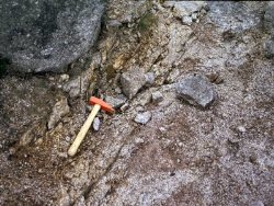
Epidote-bearing greisen veining in granite with reported cassiterite. | |
| Introduction: | |
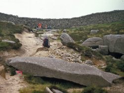
Pollaphuca is the saddle between Slieve Meelmore and Slieve Bearnagh, approximately 7km WSW of Newcastle. McKillen and Earls (1981) reported an occurrence of tin mineralization at this site, in the form of cassiterite associated with greisen veins in the Mourne Mountains G2 granite. As such, this may be the only bedrock occurrence of cassiterite in the Mourne Mountains, since rumoured occurrences at the Miners Hole beside the Silent Valley reservoir were not confirmed by exploration in the 1970s-1980s. | |
| Description: | |
 | |
| Notes: | |
See also Key Site 1129 - Mournes - The Granites - Overview. | |
| Keywords | |
|---|---|
| Minerals: | Cassiterite, Epidote |
| Rocks: | Granite, Greisen |
| Structures: | mineral vein |
| Measurements | |||||
|---|---|---|---|---|---|
| Length: | 4m | Width: | 1m | Height: | |
| Depth: | Area: | ||||
| Access | |
|---|---|
| Approach: | The greisen veins are exposed in the path leading from the Trassey track to the gap in the Mourne Wall. |
| Management: | |
Mountain outcrop accessible only by hill-walkers. At the date of the site visit in 1997, path-laying works were in progress in the area. Following discussions with the National Trust, measures were taken to prevent the visited locality (measuring about 4m long by 1m wide) from being damaged or obscured by path construction. | |
| Record type: | ESCR report | Recorded by: | R. Nawaz and N.R. Moles |
| Entered by: | E M Porter | ||
| Last updated: | 07 MAY 68 | ||
| Enlander, I., Dempster, M. & Doughty, P., 2026. Pollaphuca, Mourne Mountains, County Down, site details. [In] Earth Science Conservation Review. https://www.habitas.org.uk/escr/site.php?item=555. Accessed on 2026-11-08. |
| Previous Site | Next Site |