
| Previous Site | Next Site |
Earth Science Conservation Review
| Largy Hill, Lack | Tyrone |
| Site number: | 560 | ||
| ESCC: | EO | ||
| Locality Type: | Field | Status: | local interest |
| Grid Reference: | H271655 Centroid | ||
| Google maps: | 54.53758,-7.58131 | ||
| County: | Tyrone | Council area: | Fermanagh & Omagh District Council |
| Period: | Precambrian | ||
| Stages: | Dalradian | ||
| Site Description | |
|---|---|
 | |
| Highlights: | |
Almandine garnet in muscovite schist. | |
| Description: | |
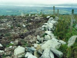
The bedrock at this site, located c.1km SSW of Lack village close to the summit of Largy Hill, comprises strongly deformed Dalradian schists. Centimetre-sized, well-formed crystals of pink-coloured almandine garnet occur abundantly within muscovite schist fragments in a ploughed field on the west side of the summit. The garnets are not gem quality as they tend to be rich in inclusions. The locality is worthy of note for obtaining specimens, but is not considered worthy of designation. | |
| Conclusions: | |
The locality is worthy of note for obtaining specimens, but is not considered worthy of designation. | |
| Notes: | |
See also Key Site 243 - Largy Quarry. | |
| Keywords | |
|---|---|
| Minerals: | Almandine, Muscovite |
| Rocks: | Schist |
| Uses | |
|---|---|
| Uses: | Agriculture. |
| Record type: | ESCR report | Recorded by: | R. Nawaz and N.R. Moles |
| Entered by: | E M Porter | ||
| Last updated: | 07 MAY 68 | ||
| Enlander, I., Dempster, M. & Doughty, P., 2026. Largy Hill, Lack, County Tyrone, site details. [In] Earth Science Conservation Review. https://www.habitas.org.uk/escr/site.php?item=560. Accessed on 2026-11-06. |
| Previous Site | Next Site |