
| Previous Site | Next Site |
Earth Science Conservation Review
| Doraville Ridge - Palaeogene | Fermanagh |
| Site number: | 80 | File Number: | H15 |
| ESCC: | EA | ||
| Locality Type: | Quarry (working) | Status: | ESCR |
| Grid Reference: | H19355655,H200558 End(s) of linear site, Not Entered | ||
| Google maps: | 54.45709,-7.7024 | ||
| County: | Fermanagh | Council area: | Fermanagh & Omagh District Council |
| Period: | Tertiary | ||
| Stages: | Tertiary Undifferentiated | ||
| Site Description | |
|---|---|
 | |
| Highlights: | |
A multiple dolerite dyke of great width intrudes both Old Red Sandstone and Carboniferous strata. Several features point to its function as a feeder to high level intrusions or surface flows. | |
| Introduction: | |
Symes and Wilkinson (1886) described a basaltic dyke which crops out as a low ridge between Castle Archdale and Enniskillen; Wilkinson and Kilroe (1881) had already noted the probable continuation of this dyke, offset to the south across the Fintona-Enniskillen fault, between Belle Isle and Gortnacarrow Bridge. The dyke rock is exposed along the low ridge, north and west of Dora Ville; the best exposures occur in the Drogan (H200558) and Doonan (H19625620 to H19355655) quarries, where the hard rock has been exploited for roadstone. Dolerite is again exposed where the Enniskillen to Lisnarrick road crosses the ridge, but exposures elsewhere are difficult to find. A detailed appraisal of the dyke is given by Preston (1967), a summary can be found in Emeleus and Preston (1969). | |
| Description: | |
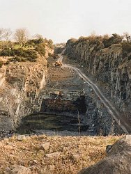
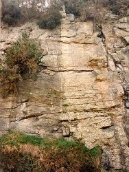
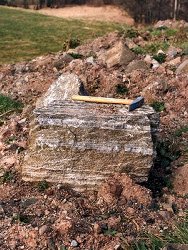
The dyke is a 90 m wide intrusion; its outer contact with the Old Red Sandstone marls was exposed in a small quarry in Doonan Townland, Irish Grid Ref. H19625620, 0.8 km NW of Dora Ville. The marls were altered to a flow banded hornfels several inches thick; cordierite gave the rock a spotted appearance; sillimanite, biotite, sanidine, and quartz occurred in the groundmass. Marginally the dyke-rock is a coarse-grained olivine dolerite with olivine-rich and olivine-poor bands but characterised by a single clinopyroxene as are most members of the Tertiary dyke swarms found in Ireland. Some rottenstone occurs patchily along the outer contact. Internal dolerite/dolerite contacts are present in this marginal rock and some appear to cross-cut the marginal banding of earlier injections. All are smooth and wavy interfaces with finer-grained selvedges or lined with columnar growths of olivine or pyroxene sometimes in alternating sequences. Towards the centre of the dyke, approximately 30 m thick in the Drogan Quarry, the dolerite becomes depleted in olivine and what olivine remains is enriched in iron. A second pyroxene makes an appearance, either pigeonite or hypersthene, and the texture of the rock changes from ophitic to intergranular. These calcium-poor pyroxenes show an inversion relationship and both exhibit exsolution lamellae. This latter feature is greatly exaggerated in the dolerite pegmatite patches and veins, that occur sporadically through the dyke-rock. The augite-pigeonite grains develop an hour-glass structure and the exsolution lamellae which define it are made conspicuous in hand specimen by a silvery schiller, see Preston (1966). Quarrying since 1966 has removed many of the described sections and exposed new ones. In the Doonan quarry the NE wall of the trench exposes pipe amygdaloids of large size filled with platy thomsonite, laumontite, analcite, and black pyroxene. Along the SW wall occur internal contacts where a finer-grained dolerite truncates the coarser-grained banded rock.
  | |
| Importance: | |
A remarkable example of a solitary feeder dyke used repeatedly by migrating magma; a contrast to the gregarious flash (single pulse) injections into well-jointed granitic rocks as in County Donegal. Basaltic compositions show a marked tholeiitic trend and the constituent pyroxenes, both calcium-rich and calcium-poor show exsolution features and inversion relationships. Internal contacts and the dolerite pegmatite patches are unusual features of dyke intrusions in the Province. | |
| Interpretation: | |
The degree of contact metamorphism and the repeated scour at internal contacts point to extensive use of the fissure by migrating basaltic magma. The present-day sections in the Doonan quarry indicate upward channelling of the later pulses of magma. A gravity high over the area (Cook and Murphy 1952) may reflect an excess of basic rock at depth and a possible source region. Standstill conditions allowed the settling of olivine and the growth of columnar crystals at internal contacts; renewed movement brought up olivine-enriched magma. The tholeiitic nature of the later dolerite is much more marked than in most other olivine dolerite intrusions, and oxidation of the iron component of the melt by an access of water from the country rock may be responsible for the change in composition and mineralogy. The pipe amygdaloids have not yet been examined in detail and the association of an augitic pyroxene with zeolite minerals is unusual and could point to a higher temperature, late magmatic origin for this cavity infill. | |
| Conclusions: | |
This site is worth conserving if quarrying leaves behind sufficient evidence of the unusual nature of the dyke. Could wait until quarrying ceases before making a final judgement on its value as a geological site. Meanwhile the progress of quarrying should be monitored and new structures and rock types photographed and sampled. | |
| Notes: | |
The Doonan quarry has been worked as far to the NW as is economic. The quarry owners own land beyond the present-day limit of quarrying but the increased thickness of overburden prohibits its exploitation. Consequently they are driving a new face back along the Doonan quarry which will deepen the trench, leave more precipitous and possibly more unstable faces and may also result in a flooded quarry floor. Flooding, dumping, and vegetation will be the major hazards threatening the geological sections; high quarry faces will be a safety hazard to any visitor. This site is also important for Mineralogy and Metallogenesis. See Key Site 532 - Doonan Quarry, Doraville. | |
| Keywords | |
|---|---|
| Minerals: | Cordierite, Sillimanite |
| Rocks: | Dolerite |
| Products: | Roadstone |
| Structures: | dyke, multiple intrusion |
| Relations: | Intrusion |
| Measurements | |||||
|---|---|---|---|---|---|
| Length: | Width: | 30-90 m | Height: | ||
| Depth: | Area: | ||||
| Access | |
|---|---|
| Approach: | Take the A32 N from Enniskillen for 5 km. Continue N on the B82 for 8 km to Dora Ville. The quarries are located 0.2 km and 0.8 km NW of Dora Ville. |
| Restrictions: | Private land. Permission required for access. |
| Threats: | Flooding, dumping and vegetation. |
| References (7) | |||
|---|---|---|---|
| Cook, A.H. & Murphy, T., 1952. Measurements of gravity in Ireland. Gravity survey of Ireland north of the line Sligo-Dundalk Dublin Institute of Advanced Studies, pt. 4 numb. 2, pp.36. | |||
| Emeleus, C.H. & Preston, J., 1969. Field excursion guide to the Tertiary volcanic rocks of Ireland., pp.70 Queen's University, Belfast. | |||
| Preston, J., 1965. Tertiary feeder dykes in the West of Ireland Proceedings of the Geological Society of London, vol. 1626, pp.149-150. | |||
| Preston, J., 1966. An unusual hourglass structure in augite American Min., vol. 51, pp.1227-1233. | |||
| Preston, J., 1967. A Tertiary feeder dyke in County Fermanagh, N. Ireland Scientific Proceedings of the Royal Dublin Society, vol. 3 pt. A, pp.1-16. | |||
| Symes, R.G. & Wilkinson, S.B., 1886. Explanatory memoir to accompany sheet 44. Memoirs of the Geological Survey of Ireland, pp.1-44. | |||
| Wilkinson, S.B. & Kilroe, J.R., 1881. Explanatory memoir to accompany sheet 57 of the maps Memoirs of the Geological Survey of Ireland, Geological Survey of Ireland. | |||
| Map(s): | The 1:25,000 O.S. map of Lower Lough Erne marks the present extent of quarrying along the Dora Ville ridge. See Preston (1967) for more detailed sketch map. | ||
| Record type: | Environment Serv. GIS, ESCR report, J. Preston l | ||
| Entered by: | Hamilton, M.J. | ||
| Last updated: | 8 Jan 2005 | ||
| Enlander, I., Dempster, M. & Doughty, P., 2026. Doraville Ridge - Palaeogene, County Fermanagh, site details. [In] Earth Science Conservation Review. https://www.habitas.org.uk/escr/site.php?item=80. Accessed on 2026-11-06. |
| Previous Site | Next Site |