
| Previous Site | Next Site |
Earth Science Conservation Review
| Blackslee Dyke | Fermanagh |
| Site number: | 81 | File Number: | H05 |
| ESCC: | ED | ||
| Locality Type: | Inland exposure, Quarry (disused) | Status: | ESCR |
| Grid Reference: | H080557,H073565 End(s) of linear site, Not Entered | ||
| Google maps: | 54.45021,-7.87665 | ||
| County: | Fermanagh | Council area: | Fermanagh & Omagh District Council |
| Period: | Tertiary, Carboniferous | ||
| Stages: | Asbian, Tertiary Undifferentiated | ||
| Lithostrat: | Carboniferous Undivided | ||
| Site Description | |
|---|---|
 | |
| Highlights: | |
A solitary dolerite dyke follows a braided fissure through Carboniferous strata. Septa of wall rock are shattered and locally the dyke-rock is crowded with xenoliths. | |
| Introduction: | |
This dyke is shown on the 1" Geological Map of the Geological Survey of Ireland, Symes and Wilkinson (1884); it is also figured on the Derrygonnelly and Marble Arch sheet 44, 56 and 43 published in 1990. Wilson (1964) offered the first detailed description of the dyke; quarrying modified the exposures and more up to date sections through the dyke were drawn for the Nature Reserves Committee in 1972. | |
| Description: | |
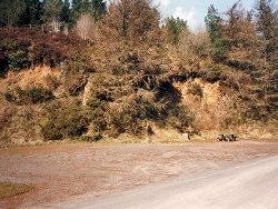
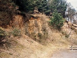
The dyke, 6.5-15.5 m wide, occurs in Navar Forest in the townland of Blackslee, south of the Magho Cliffs in Co. Fermanagh; its course through Carboniferous (Asbian) strata follows a NW trending fault which downthrows to the NE. It intersects Dartry Limestone, Meenymore, and Glenade Sandstone Formations. At its most southeasterly exposure it intrudes shales and sandstones of the Meenymore Formation; a small forest roadside quarry at the Achameelan viewpoint (Irish Grid Ref. H081557) offers a section which has changed in aspect due to quarrying since Wilson's 1964 observations, and which is now somewhat obscured by vegetation. Gravel pits have exploited the rotten weathered dolerite to the NE, and a second quarry at Irish Grid Ref. H07655610 is less vegetated.
 | |
| Importance: | |
A multiple/braided dyke showing evidence of phreato-magmatic activity; one of the few localities in the Province where quartz paramorphs after tridymite can be found. | |
| Interpretation: | |
This dyke is one member of a local swarm trending NW-SE across the Magho - Blackslee - Church Hill region. Unlike its neighbours there is evidence for repeated use of the same fracture zone which could have been fault controlled. Initally the quarry section (H080557) exposed a typical multiple dyke, but as quarrying uncovered fresh sections it became obvious that individual injections of basaltic magma were following individual fissures. These could have originated in an anastomozing system of faults. Brecciation of the sandstone and shale strata may have been due to fault movement or to steam explosions as the basaltic magma invaded water-rich sediment; phreato-magmatic activity is more likely to have resulted in the patchy, high incidence of xenoliths. | |
| Conclusions: | |
The quarry sections and the unusual nature of the dyke warrant its conservation for both teaching and research purposes. | |
| Notes: | |
The dolerite and country rock are both rubbly and the quarry faces will need clearing of vegetation and reworking from time to time. The best locality for baked sandstone xenoliths (H073565) is now obscured, but a scree slope further NW yields similar material. | |
| Keywords | |
|---|---|
| Minerals: | Tridymite |
| Rocks: | Dolerite |
| Products: | Gravel |
| Structures: | dyke, multiple intrusion |
| Relations: | Intrusion |
| NonGeol: | Some of the disused quarries are used as carparks |
| Measurements | |||||
|---|---|---|---|---|---|
| Length: | Width: | 6.5-15.5 m | Height: | ||
| Depth: | Area: | ||||
| Access | |
|---|---|
| Approach: | Exposures occur beside the scenic drive through Navar Forest. |
| References (3) | |||
|---|---|---|---|
| Johnston, T.P., Legg, I.C., Mitchell, W.I., Smith, R.A. & Young, R.S.M., 1990. Geological map of Derrygonnelly and Marble Arch Geological Survey of N. Ireland. | |||
| Symes, R.G. & Wilkinson, S.B., 1886. Explanatory memoir to accompany sheet 44. Memoirs of the Geological Survey of Ireland, pp.1-44. | |||
| Wilson, R.L., 1964. The Tertiary dykes of Magho Mountain, County Fermanagh Irish Naturalists Journal, vol. 14, pp.254-257. | |||
| Map(s): | Forest paths, carparks etc. are marked on the 1:25,000 O.S. map for Lower Lough Erne; the geology is portrayed on the 1:50,000 Geological Survey sheet for Derrygonnelly. | ||
| Record type: | Environment Serv. GIS, ESCR report, J. Preston l | ||
| Entered by: | Hamilton, M.J. | ||
| Last updated: | 23 Dec 2003 | ||
| Enlander, I., Dempster, M. & Doughty, P., 2026. Blackslee Dyke, County Fermanagh, site details. [In] Earth Science Conservation Review. https://www.habitas.org.uk/escr/site.php?item=81. Accessed on 2026-11-05. |
| Previous Site | Next Site |