
| Previous Site | Next Site |
Earth Science Conservation Review
| Mournes - Kilbroney River Section | Down |
| Site number: | 1107 | ||
| ESCC: | EO | ||
| Locality Type: | Stream section | Status: | ASSI |
| Grid Reference: | J207221 Centroid | ||
| Google maps: | 54.13426,-6.15338 | ||
| County: | Down | Council area: | Newry, Mourne & Down District Council |
| Period: | Tertiary | ||
| Stages: | Eocene | ||
| Lithostrat: | Granite | ||
| Site Description | |
|---|---|
 | |
| Highlights: | |
A gradational contact between the G4 and G5 granites of the Western Mournes. | |
| Introduction: | |
In a few places the usual sharp contact between the two granite intrusions which comprise the Western Mourne Mountains is replaced by a gradational contact which shows disintegration and assimilation of the older by the younger granite. The Kilbroney River section is probably the easiest to access. | |
| Description: | |
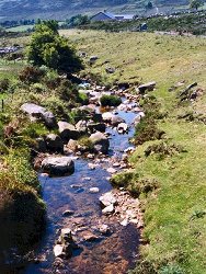
Exposures in the river bed downstream from the road bridge show all stages in the disintegration of xenoliths of the granite G4 in the finer-grained granite G5. The younger or inner granite contains coarse-grained porphyritic areas together with patches crowded with groups of large quartz and feldspar crystals. The coarse-grained areas with their mantle of porphyritic rock vary in size from 10 cm to several metres across. | |
| Importance: | |
A well exposed example of magmatic stoping and assimilation on a small scale. | |
| Interpretation: | |
The coarse-grained granitic areas are relics of G4 texture and the first sign of alteration is the development of fine-grained veins speckled with dark quartz. Such veins increase in abundance penetrating along crystal boundaries and separating individual crystals and composite fragments; in this way a xenoporphyritic mantle grows and grades into the younger host rock. Such assimilation is restricted to a narrow zone along the contact. The G4 granite was probably well consolidated when G5 was emplaced. | |
| Notes: | |
For Mourne Granites general information and reference list see; Key Site 1129 - The Granites - Overview. For general information on the cone-sheet intrusions associated with the Mourne Granites, and the Mourne Mountain dyke swarm, see; Key Site 1131 - Cone-sheet and Dyke Swarm - Overview. | |
| Keywords | |
|---|---|
| Rocks: | Granite |
| Structures: | ring-dyke, xenoliths |
| Relations: | Contact, Intrusion |
| NonGeol: | Farm land, grazing. |
| Measurements | |||||
|---|---|---|---|---|---|
| Length: | 100m | Width: | Height: | ||
| Depth: | Area: | ||||
| Access | |
|---|---|
| Approach: | All exposures occur in the banks and bed of the Kilbroney River downstream from the road bridge, Grid Ref J207221. Flood waters will from time to time restrict access; stream sediment may shift and affect the degree of exposure. |
| Threats: | Shifting stream sediment may affect the degree of exposure. |
| Map(s): | Emeleus's (1955) fig.1 and the 1 inch Geological Survey map (1978) show the relevant geology. | ||
| Record type: | ESCR report | ||
| Entered by: | E M Porter | ||
| Enlander, I., Dempster, M. & Doughty, P., 2026. Mournes - Kilbroney River Section, County Down, site details. [In] Earth Science Conservation Review. https://www.habitas.org.uk/escr/site.php?item=1107. Accessed on 2026-11-06. |
| Previous Site | Next Site |