
| Previous Site | Next Site |
Earth Science Conservation Review
| Mournes - Lindsay's Leap, Thomas's Mountain | Down |
| Site number: | 1103 | ||
| ESCC: | ED | ||
| Locality Type: | Quarry (disused) | Status: | ASSI |
| Grid Reference: | J373291 Approximate | ||
| Google maps: | 54.19294,-5.8964 | ||
| County: | Down | Council area: | Newry, Mourne & Down District Council |
| Period: | Tertiary | ||
| Stages: | Eocene | ||
| Lithostrat: | Granite | ||
| Site Description | |
|---|---|
 | |
| Highlights: | |
Numerous replacement veins, in contrast to the many intrusive veins, in the G2 Granite introduced iron, fluorine, and water to form topaz, fluorspar, siderophyllite, and stilbite. | |
| Introduction: | |
Richey (1928) noted their occurrence as replacement by vapour-action of granite bordering contraction-fissures. Nockolds and Richey (1939) described in detail the mineralogy of several types of replacement veins from various localities, notably those at Lindsay's Leap. | |
| Description: | |
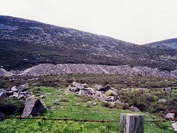
Green greisen veins abound in a disused granite quarry near Lindsay's Leap on the northeastern shoulder of Thomas's Mountain overlooking Newcastle, Co. Down. The veins vary from a few millimetres to 7-8 cms in width, are vertical or steeply inclined to the SSW, and trend parallel to the outer contact of the granite against the Silurian wall-rock. In the disused quarry the veins are conspicuous, in situ, across the flat-lying joints at the foot of the old quarry face. They also abound in the broken rock which is heaped on the old quarry floor.
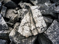 The veins post-date the emplacement of aplite veins in the granite and appear to be localised in their occurrence. In hand specimen they appear to be composed of a fine granular aggregate of green mica and grey quartz; in some instances the mica and quartz are concentrated at the margin and centre of the vein repectively. The margins of the veins are well defined but not very sharp. Some examples show a narrow central vein of topaz, about 1 mm thick. The mica occurs in small aggregates associated with topaz and quartz and occasionally with dark green chlorite and colourless fluorspar. The mica is blue-green in colour, in thin-section, and may show cores of brown biotite, altered in part to chlorite, identical to that in the host granite. A zeolite mineral, stilbite, can occur in the interstices of the vein associated with chlorite and possible kaolinite. A chemical analysis (Nockolds and Richey 1939) of the blue-green mica shows a high ferrous iron and fluorine content and the authors identify it as siderophyllite, a rare species of mica. | |
| Importance: | |
Pneumatolytic alteration of the Mourne granites can be seen at a number of localities, though the large scale kaolinisation has been encountered only in underground excavations (Robbie 1955) and in bore- cores. Greisen veins have been recorded from a number of localities as green, grey, and black veins (these darker types carrying manganese and iron oxide minerals), but the locality near Lindsay's Leap is so rich in examples of the green veins that it is by far the best locality to visit. | |
| Interpretation: | |
Vapours and fluids rising from still congealing granite magma at depth escaped along near vertical joints through the solid granite above; joints which appear to run parallel to the wall of the ring-dyke intrusion. Iron, fluorine, and water with minor amounts of aluminium and lithium were carried up by this pneumatolytic process and replaced the original granitic minerals either side of the open joint. Feldspar especially and to some extent the biotite were replaced by the blue- green mica and topaz. The fate of the displaced potassium, calcium, and sodium is uncertain; interstitial stilbite could account for some of these elements. The quartz is probably residual. Kaolinisation of the feldspar is probably the first stage in the replacement process and would account for the zone of opaque feldspar seen on either side of the greisen vein. The original biotite was probably slightly chloritised at this stage, and tiny flakes of white mica and a little fluorspar appeared. A later stage produced a mica-topaz assemblage at the expense of feldspar and white mica. Residual quartz is inherited from the altered granite but in some veins additional quartz has been introduced to develop a quartz-rich centre. | |
| Conclusions: | |
The best surface exposure of pneumatolytically altered granite. A good excursion locality. The old quarry face and the spoil heap in front comprise the desired conservation area. | |
| Notes: | |
Material abounds in the quarry debris and shows little sign of being overgrown. Reworking of the quarry seems unlikely since cleaner rock can be had at the working quarry, which itself seems to be in decline. For Mourne Granites general information and reference list see; Key Site 1129 - The Granites - Overview. For general information on the cone-sheet intrusions associated with the Mourne Granites, and the Mourne Mountain dyke swarm, see; Key Site 1131 - Cone-sheet and Dyke Swarm - Overview. This site is also important for Mineralogy and Metallogenesis. See Key Site 541 - Lindsay’s Leap, Mourne Mountains. | |
| Keywords | |
|---|---|
| Minerals: | Fluorite, Stilbite, Topaz |
| Rocks: | Granite, Greisen, Greisenized Granite |
| Products: | Ornamental stone |
| Structures: | mineral vein |
| Relations: | Intrusion |
| NonGeol: | Open moorland for sheep grazing and hill walking. |
| Measurements | |||||
|---|---|---|---|---|---|
| Length: | Width: | 2-80mm | Height: | ||
| Depth: | Area: | ||||
| Access | |
|---|---|
| Approach: | Access involves a steep climb through Donard Forest, either following the track up the Glen River to the edge of the forest and traversing ESE past the old Ice House onto the lower flank of Thomas's Mountain (the working quarry road would lead one to the same height and within sight of the disused quarry), or ascending the old mineral railway (Bogie Track) from above the harbour on the south side of Newcastle. |
| Restrictions: | There need be no restrictions on sampling. |
| Management: | |
Some control would be necessary to preserve the quarry face and some of the loose stone, should development happen as proposed. | |
| Development: | A proposal to use the old Bogie Track as access to a viewpoint overlooking the Co. Down coast could use the quarry spoil or site buildings on the quarried terrace. |
| Map(s): | Text-fig. 1 in Nockolds & Richey (1938) is a useful guide. Quarry is also marked on the O.S. Mourne Country Outdoor Pursuits Map, 1:25000. Relevant geology on 1:25000 map. | ||
| Record type: | ESCR report | ||
| Entered by: | E M Porter | ||
| Enlander, I., Dempster, M. & Doughty, P., 2026. Mournes - Lindsay's Leap, Thomas's Mountain, County Down, site details. [In] Earth Science Conservation Review. https://www.habitas.org.uk/escr/site.php?item=1103. Accessed on 2026-11-06. |
| Previous Site | Next Site |