
| Previous Site | Next Site |
Earth Science Conservation Review
| Slieve Gullion Ring - Crooked Road | Armagh |
| Site number: | 1120 | ||
| ESCC: | EO | ||
| Locality Type: | Crag, Crags | Status: | ASSI |
| Grid Reference: | J00152405 Centroid | ||
| Google maps: | 54.15574,-6.46777 | ||
| County: | Armagh | Council area: | Newry, Mourne & Down District Council |
| Period: | Tertiary, Devonian | ||
| Stages: | Devonian Undifferentiated, Palaeogene | ||
| Lithostrat: | Lislea Granophyre, Newry Granodiorite, Slieve Gullion Complex | ||
| Site Description | |
|---|---|
 | |
| Description: | |
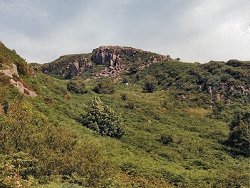
0.6 km W of Lislea Church, a steep sided gully runs northwards from a northerly bend on the Crooked Road; prominent crags overlook the gully in its upper reaches. The rocky gully exposes the central and outer margin of the Porphyritic Granophyre ring-dyke. At its centre the granophyre carries abundant rounded xenoliths of a fine-grained acid rock up to 1 m in diameter. Northwards up the gully the outer marginal zone of the granophyre shows intense crushing as does the wall rock of Newry Granodiorite. | |
| Importance: | |
This site offers a useful section through the Porphyritic Granophyre. Multiple intrusion along the ring-fracture can be claimed; the later surge of acid magma carrying up well digested xenoliths of possible Newry Granodiorite (Emeleus 1970). The transformation of the older Caledonoid intrusion into a younger Tertiary granitic rock has been claimed and disputed by many workers. | |
| Notes: | |
For reference list see; Key Site 1118 - Slieve Gullion Ring - Overview | |
| Keywords | |
|---|---|
| Rocks: | Granodiorite, Granophyre |
| Structures: | ring-dyke, xenoliths |
| Relations: | Intrusion |
| Access | |
|---|---|
| Approach: | Lislea village lies 4.5 km SW of Camlough village, on the Camlough to Forkill road. The locality is situated 0.6 km W of Lislea, along the Crooked Road. |
| Map(s): | For site location see the 1:50,000 O.S. Sheet 29 (The Mournes) Discoverer Series. | ||
| Record type: | ESCR report | ||
| Entered by: | E M Porter | ||
| Enlander, I., Dempster, M. & Doughty, P., 2026. Slieve Gullion Ring - Crooked Road, County Armagh, site details. [In] Earth Science Conservation Review. https://www.habitas.org.uk/escr/site.php?item=1120. Accessed on 2026-11-08. |
| Previous Site | Next Site |