
| Previous Site | Next Site |
Earth Science Conservation Review
| Slieve Gullion Ring - Forest Quarry | Armagh |
| Site number: | 1128 | ||
| ESCC: | ED | ||
| Locality Type: | Quarry (disused) | Status: | ASSI |
| Grid Reference: | J019192 Centroid | ||
| Google maps: | 54.11228,-6.44185 | ||
| County: | Armagh | Council area: | Newry, Mourne & Down District Council |
| Period: | Tertiary | ||
| Stages: | Palaeogene | ||
| Lithostrat: | Slieve Gullion Complex | ||
| Site Description | |
|---|---|
 | |
| Description: | |
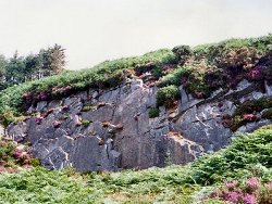
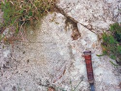
Reynolds' layers 7, 8 & 9, were renamed the 'partition' by Bailey and McCallien. They contain fragments of the Newry Granodiorite which are made over in various degrees to hybrid and Tertiary microgranites. The fresh quarry face exposed all such rock types; the hybrids contained vughs lined with actinolite needles. Weathering of the in situ rock and removal of the quarried debris has obscured the rock types and relationships. Fresh exposures
 | |
| Importance: | |
Reynolds (1951) believed these rocks to be layers of agglomerate intercalated in the pile of lavas and tuffs; Bailey and McCallien (1956) described them as screens of older granodiorite, largely remade into Tertiary granophyre by the intrusion of the summit granophyres and microgranites. | |
| Notes: | |
For reference list see; Key Site 1118 - Slieve Gullion Ring - Overview | |
| Keywords | |
|---|---|
| Minerals: | Actinolite |
| Rocks: | Granite, Granodiorite, Granophyre, Microgranite |
| Structures: | magma mixing, vugh, xenoliths |
| Relations: | Intrusion |
| Access | |
|---|---|
| Approach: | This locality is a small disused quarry beside the forest scenic drive over Slieve Gullion. It is sited above the road and roadside carpark where the return drive reaches its most southerly course on the SW slopes of the mountain and turns northwards. The scenic drive may be accessed from the SW and SE of Slieve Gullion. |
| Map(s): | For site location see the 1:50,000 O.S. Sheet 29 (The Mournes) Discoverer Series. | ||
| Record type: | ESCR report | ||
| Entered by: | E M Porter | ||
| Enlander, I., Dempster, M. & Doughty, P., 2026. Slieve Gullion Ring - Forest Quarry, County Armagh, site details. [In] Earth Science Conservation Review. https://www.habitas.org.uk/escr/site.php?item=1128. Accessed on 2026-11-08. |
| Previous Site | Next Site |