
| Previous Site | Next Site |
Earth Science Conservation Review
| Slieve Gullion Ring - Mullaghbawn North | Armagh |
| Site number: | 1121 | ||
| ESCC: | EO | ||
| Locality Type: | Roadside section | Status: | ASSI |
| Grid Reference: | H977187 Centroid | ||
| Google maps: | 54.10861,-6.50621 | ||
| County: | Armagh | Council area: | Newry, Mourne & Down District Council |
| Period: | Tertiary | ||
| Stages: | Palaeogene | ||
| Lithostrat: | Lislea Granophyre, Porphyritic Felsite, Slieve Gullion Complex | ||
| Site Description | |
|---|---|
 | |
| Description: | |
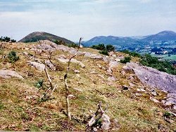
A 1-1.5 km long arc along the 'ring' offers a number of interesting relationships between the ring-dykes, vent agglomerates and associated basic intrusions; Richey's (1932) geological sketch map of the Cashel district is a useful field guide. N of the minor road the Porphyritic Felsite and vent agglomerate can be seen, the latter composed of trachyte lava fragments. A little further N the actual junction between the Porphyritic Felsite and Porphyritic Granophyre is exposed, and their age relationships can be established. The felsite is veined by the granophyre which is strongly chilled at the contact. S of the minor road the vent contains larger masses of trachyte and again the contact between agglomerate/felsite and felsite/granophyre can be found. | |
| Importance: | |
A useful and accessible area, well exposed and offering a good section through the rocks along the ring-fault. The age relationships of the two ring-dykes were established here, and the occurrence of large slumped masses of trachytic lava into the explosive vents is restricted to this locality. | |
| Notes: | |
For reference list see; Key Site 1118 - Slieve Gullion Ring - Overview | |
| Keywords | |
|---|---|
| Rocks: | Agglomerate, Felsite, Granophyre, Trachyte |
| Structures: | ring-dyke, ring-fault, volcanic vent |
| Relations: | Intrusion |
| Measurements | |||||
|---|---|---|---|---|---|
| Length: | ~200 m | Width: | Height: | ||
| Depth: | Area: | ||||
| Access | |
|---|---|
| Approach: | Drive W out of Mullaghbane Village for approximately 1 km. At a Y junction take the right road; follow this quite winding road until its next junction (with the Cashel Road). Here turning S, the length of section begins. |
| Map(s): | For site location see the 1:50,000 O.S. Sheet 28 (Monaghan). | ||
| Record type: | ESCR report | ||
| Entered by: | E M Porter | ||
| Enlander, I., Dempster, M. & Doughty, P., 2026. Slieve Gullion Ring - Mullaghbawn North, County Armagh, site details. [In] Earth Science Conservation Review. https://www.habitas.org.uk/escr/site.php?item=1121. Accessed on 2026-11-08. |
| Previous Site | Next Site |