
| Previous Site | Next Site |
Earth Science Conservation Review
| Slieve Gullion Ring - Mullaghbawn South | Armagh |
| Site number: | 1123 | ||
| ESCC: | EO | ||
| Locality Type: | Scarp face | Status: | ASSI |
| Grid Reference: | H98151760 Centroid | ||
| Google maps: | 54.09865,-6.50045 | ||
| County: | Armagh | Council area: | Newry, Mourne & Down District Council |
| Period: | Tertiary, Devonian | ||
| Stages: | Devonian Undifferentiated, Palaeogene | ||
| Lithostrat: | Newry Granodiorite, Slieve Gullion Complex | ||
| Site Description | |
|---|---|
 | |
| Description: | |
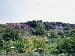
An isolated dolerite plug cuts Newry Granodiorite and is cut by granitic veins. | |
| Importance: | |
The age of these small dolerite/gabbro masses associated with the ring-fault has been in dispute. Apparent veining by the Caledonian Granodiorite of Newry prompted Richey and Thomas (1932) to quote an earlier date, but Reynolds (1941) reinterpreted the contact relations, and claimed a Tertiary age for the dolerite. She also demonstrated that progressive alteration of the granodiorite and marginal modification of the dolerite, within a 150 mm wide zone, produced a series of rock compositions comparable to the normal magma Series of Mull - a series attributed to crystal fractionation! The critical exposure occurs in the scarp face above a farm drive. The site is badly overgrown, as it was in Richey's time, and some clearing will be necessary to expose Reynolds' figured contact. | |
| Notes: | |
For reference list see; Key Site 1118 - Slieve Gullion Ring - Overview | |
| Keywords | |
|---|---|
| Rocks: | Dolerite, Granodiorite |
| Structures: | plug, ring-fault |
| Relations: | Intrusion |
| Access | |
|---|---|
| Approach: | Drive W out of Mullaghbane village for approximately 1 km. At the Y junction take the left road S towards Carrive for a further 1 km. The critical exposure occurs in the scarp face above the 2nd farm drive after the Y junction. |
| Map(s): | For site location see the 1:50,000 O.S. Sheet 28 (Monaghan). | ||
| Record type: | ESCR report | ||
| Entered by: | E M Porter | ||
| Enlander, I., Dempster, M. & Doughty, P., 2026. Slieve Gullion Ring - Mullaghbawn South, County Armagh, site details. [In] Earth Science Conservation Review. https://www.habitas.org.uk/escr/site.php?item=1123. Accessed on 2026-11-08. |
| Previous Site | Next Site |