
| Previous Site | Next Site |
Earth Science Conservation Review
| Faragandoo | Antrim |
| Site number: | 113 | ||
| ESCC: | EF | ||
| Locality Type: | Coastal section | Status: | ASSI |
| Grid Reference: | D165428 Centroid | ||
| Google maps: | 55.21893,-6.16946 | ||
| County: | Antrim | Council area: | Causeway Coast & Glens Borough Council |
| Period: | Carboniferous | ||
| Stages: | Dinantian | ||
| Lithostrat: | Fair Head Tuff Formation | ||
| Site Description | |
|---|---|
 | |
| Highlights: | |
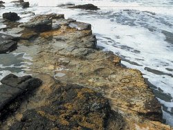
The foreshore north of Faragandoo exposes a ten metre thick sequence of epiclastic ash deposits which range from fine mudstone to conglomerate. At two levels excellent palaeosol profiles can be seen, with lycopod stumps and root systems preserved in situ. Lacustrine muds overlying one of these palaeosols contain beautifully preserved plant remains. Sediment fills from within the lycopod roots have yielded terrestrial arthropod remains. | |
| Introduction: | |
Massive blocks of Tertiary dolerite and of Carboniferous sandstone fallen from the cliffs above obscure much of the foreshore exposure on the west side of Fair Head. However, north of Faragandoo a series of gently dipping rock ledges expose a series of Carboniferous volcanic tuffs and associated palaeosols. Little has been published on this part of the Carboniferous succession other than brief accounts by Wright (1924) and Wilson and Robbie (1966); the latter authors mention the exceptional preservation of some of the plant material (p. 71). | |
| Description: | |
Between the Carboniferous basalts and the Murlough Bay Coal Group is an unnamed sequence of tuffaceous sediments about 60 metres thick. These tuffs are referred to here informally as the Fair Head Tuff Formation. They are poorly exposed as the outcrop largely is obscured by the Fair Head block scree. However, at this one locality about a 10 metre thickness can be examined over the extensive foreshore exposure. The lowest unit seen, extending upwards for about 3 metres from LWM, is termed here the 'Lower Forest Horizon'. Throughout much of its thickness large stigmarian root casts are present and, in places, can be seen to radiate out from lycopod stump casts. 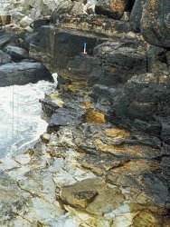 The plant remains are the subject of ongoing research by Dr. Andrew Scott at the University of London, Royal Holloway. Sediment infills from stigmarian roots in the 'Lower Forest Horizon' have yielded terrestrial arthropod micro-remains to Dr. Andrew Jeram. Mites are particularly abundant, with centipedes, spiders and a wide range of other arthropods represented by fragmentary remains. Several of the oribatid mites have been described as new by Antonio Arillo (Universidad Complutense, Madrid, Spain). He proposes the following new taxa (all gen. nov. et sp. nov.): Gehypoacaronychus hibernicus, Eogehypochthonius jerami, Protomesoplophora bella, Eogehyacaronychus ortunoi, Monaphelacarus carboniferus, and Carbochthonius antrimensis. | |
| Importance: | |
The site is of international importance for its terrestrial arthropod communities. Previously described faunas have been obtained from the Middle and Upper Devonian and from the Upper Carboniferous, but this is the first Lower Carboniferous fauna to be discovered. Since it preserves a complete micro-arthropod community it may come to play a significant role in our understanding of the evolution of individual arthropod groups, of communities, and of early terrestrial ecosystems in general. The site also is of importance on a national scale. It is the only extensive exposure of the Fair Head Tuff Formation and the plant remains are among the best preserved of any from the Carboniferous of Ireland. It appears to be the only locality in Ireland where Carboniferous 'forest' horizons are well exposed and can be examined both in profile and in plan. | |
| Interpretation: | |
The Fair Head Tuff Formation consists largely of epiclastic ashes eroded from the unconsolidated flanks of basaltic ash cones. The latter presumably were a continuation of the volcanic phase which produced the underlying basalt flows. Pulses of sediment were deposited in the Fair Head area, which for much of the time must have been an emergent land surface. Preservation of palaeosol profiles at various stages of development may perhaps be attributable to fluctuating water table levels. The hollow tree stumps of the Lower Forest Horizon appear to have acted as natural pitfall traps and, combined with the generally rather waterlogged environment, provided an ideal micro-environment for preservation of soil and/or leaf-litter arthropod communities. Changing species composition of the plant material preserved in the lacustrine mudstone overlying the Lower Forest Horizon hints at an ecological succession in the vegetation of the area. | |
| Conclusions: | |
Intermittent volcaniclastic deposition during the early Carboniferous in the Ballycastle region led to the development of a succession of soils. The stumps of plants rooted in these soils are still preserved and, through acting as ancient pitfall traps, contain the remains of a range of terrestrial arthropods. A lacustrine mudstone unit overlying the lower of the two palaeosols yields a diverse and well-preserved flora. | |
| Notes: | |
F or general information and references on the Palaeontology of Northern Ireland see Key Site 109 - Palaeontological sites of N. Ireland - Introduction For other site specific information and references on the Palaeontology of Northern Ireland see Key Site 110 - Ballycastle Pellet Chalk, Key Site 111 - Ballypalady Plant Bed, Key Site 112 - Carrick Lough, Bunnahone Lough and the Sillees River, Key Site 114 - Minnis North Mudflow, Key Site 115 - Moyola River, Key Site 116 - Mullynaskeagh Clay Pit, Key Site 117 - Murlough Bay, Key Site 118 - Portnaloub, Key Site 119 - Sillees River, Glenasheevar, Key Site 120 - Tircrevan Burn, and Key Site 121 - Tullyconnell. | |
| Keywords | |
|---|---|
| Rocks: | Conglomerate, Mudstone, Shale, Tuff |
| Fossil Groups: | Arthropod, Plant |
| Structures: | palaeosol |
| Measurements | |||||
|---|---|---|---|---|---|
| Length: | Width: | Height: | 10m | ||
| Depth: | Area: | ||||
| Access | |
|---|---|
| Management: | |
As a foreshore exposure the site requires no specific management and hence no management recommendations are made here. The existing block scree landward of the main exposures should help to protect the site from most future cliff falls. | |
| Uses | |
| Uses: | The site is a foreshore exposure extending from low water to about 2 metres above high water. Above this level the succession is largely obscured by large blocks fallen from the cliffs above. |
| References (3) | |||
|---|---|---|---|
| Mitchell, W.I., 1995. The Carboniferous System in Northern Ireland - Earth Science Conservation Review (Unpublished Report) 6 vols, 430 pp, Department of the Environment. | |||
| Wilson, H.E. & Robbie, J.A., 1966. Geology of the country around Ballycastle. Memoirs of the Geological Survey Northern Ireland. | |||
| Wright, W.B., 1924. The Geology of the Ballycastle Coalfield. Memoirs of the Geological Survey of Ireland. | |||
| Record type: | ESCR report | Recorded by: | Michael J. Simms, Department of Geology, Ulster Mu |
| Entered by: | E M Porter | ||
| Last updated: | 23 Dec 2003 | ||
| Enlander, I., Dempster, M. & Doughty, P., 2026. Faragandoo, County Antrim, site details. [In] Earth Science Conservation Review. https://www.habitas.org.uk/escr/site.php?item=113. Accessed on 2026-11-06. |
| Previous Site | Next Site |