
| Previous Site | Next Site |
Earth Science Conservation Review
| Fardross Stream - Carboniferous | Tyrone |
| Site number: | 253 | File Number: | H54 |
| ESCC: | EO | ||
| Locality Type: | Stream section | Status: | ASSI |
| Grid Reference: | H52224883,H52584844 End(s) of linear site, Not Entered | ||
| Google maps: | 54.38561,-7.19653 | ||
| County: | Tyrone | Council area: | Mid Ulster District Council |
| Period: | Carboniferous | ||
| Stages: | Visean | ||
| Lithostrat: | Benbulben Shale Formation, Bundoran Shale Formation, Dartry Limestone Formation, Glencar Limestone Formation, Mullaghmore Sandstone, Tyrone Group | ||
| Site Description | |
|---|---|
 | |
| Highlights: | |
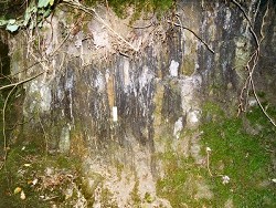
The succession of rocks exposed in the Fardross Forest stream cover five formations of the Tyrone Group and range in age from the mid-Arundian to the Asbian. Because of unusual structural conditions the strata are vertically disposed and, as far as the author is aware, this sequence cannot be replicated in any other one section in Northern Ireland and is therefore unique. | |
| Description: | |
The stream section in Fardross Forest is located ~3.3km SSW of Clogher Cathedral. The section of the stream in which the strata occur is ~600m long and extends from the sharp bend (H5222 4883) at the northern margin of the forest, to the SSE, to a sharp bend (H5258 4844), 200m upstream from the roadbridge. The course of the stream is followed by the Fardross Forest 'River Walk', a pedestrian path that crosses the stream at two places in its mid- section, at artificial concrete stepping stones numbering 6, at the northern point, and 9 at the southern crossing. The Fardross stream section is located on the northern flank of Slieve Beagh. It is one of a number of outcrops of Tyrone Group strata that occur on the south side of the Clogher Valley Fault in this area; much of Slieve Beagh being formed of the Meenymore Formation of the Leitrim Group (GSNI, 1983, 1:50,000 Sheet 46). Of all these Tyrone Group outcrops the Fardross section extends to a much lower level in the succession than any of the others, which rarely extend below the Dartry Limestone Formation. The northern margin of the Fardross 'inlier' is formed by the Clogher Valley Fault which is located very close to the north end of the section. The SW side of the 'inlier' is also faulted but to the NE, the succession is uninterrupted by faults and eventually passes up, again, into the Meenymore Formation, SE of the southern end of the section. Strata at the northern end of the section are arranged either vertically or inclined very steeply to the SE. Their proximity to the Clogher Valley Fault has resulted in severe brecciation, calcite veining and some recrystallisation. Higher in the section, to the SE, bedding is still almost vertical but the incidence of fault-related structures is negligible. Even at the SE end of the section, bedding in the Dartry Formation is inclined southeastwards at up to 60 deg. I - BUNDORAN SHALE FORMATION The most northerly outcrops in the Fardross section at H5223 4886 consist of limestones that are heavily net-veined, brecciated and recrystallised. Apart from crinoid ossicle debris no other macrofauna was found here. A sample of relatively unaltered and untectonised limestone was found however to contain a prolific microbiota including the following forms: Foraminifera: Algae: --------------------------------------------------------------- Bogushella ziganensis Baituganella sp. Brunsia spirillinoides forchiinid Endothyra sp. Koninckopora inflata E. bowmani Nannopora anglica E. ex. gr. phrissa stacheiinid Endothyranopsis sp. Ungardella sp. Eostaffella sp. Gigasbia sp. Glomodiscus sp. Lysella sp. Mediocris sp. Paraarchaediscus stage involutus P. ninae Plectogyranopsis convexa Tetrataxis sp. The mutual presence of Lysella, Glomodiscus and Paraarchaediscus stage involutus suggests a mid-Arundian age. II - MULLAGHMORE SANDSTONE FORMATION The main outcrop of the Mullaghmore Sandstone commences about 30m south of the Foot Bridge, at the north end of the section and extends upstream for ~140m. With an inclination of ~70 deg. the thickness of the Mullaghmore Sandstone is estimated at 140-150m in the Fardross section. Whilst sandstones are the dominant lithology, they are always interbedded with dark grey mudstones and siltstone and less commonly with dark mudstones containing a marine fauna and thin crinoidal limestones. The sandstones, in the lower part of the section are mainly pale brown to red-brown, medium-grained, calcareous and feldspathic. Very calcareous parallel laminated, crinoidal sandstones in this part of the formation are graded, with a crinoid-rich top, and contain a restricted microbiota of algae. Higher in the formation medium grey micaceous mudstones and thin to thick sandstones are common and a 0.32m thick bed of very sandy crinoidal packstone contains the following microbiota: Foraminifera: Algae: --------------------------------------------------------------- cf. Endothyranopsis sp. Coelosporella sp. cf. Globoendothyra sp. Koninckopora inflata Paraarchaediscus stage involutus K. minuta Pseudoammodiscus sp. Nannopora anglica Uralodiscus sp. Spumisalebra sp. Viseidiscus stacheiinid The presence of Paraarchaediscus stage involutus, Uralodiscus and Viseidiscus indicates a mid- to late-Arundian age. Lying above this bed are dark grey mudstones and silty mudstones that contain a rich assemblage of marine fossils including crinoid ossicles and echinoid spines, the bivalves Aviculopecten sp., Leiopteria lunulata, Pteronites angustatus, ?Schizodus sp. and Streblopteria sp. and the brachiopod Productus garwoodi, a common component of mid-Arundian faunas. The highest beds of the Mullaghmore Sandstone outcrop above and below the 6-block concrete stepping stones at H5226 4867. The blocks rest on sandstones that are medium grey, fine- to medium- grained, parallel laminated, calcareous and micaceous. For ~1.9m south of the blocks, in the river bed, the sandstones are grey- green. These are overlain (beds are sub-vertical) by a 0.34m bed of dark grey, micaceous, very calcareous, silty fine-grained sandstone containing crinoid debris in the top 0.03m and is the topmost stratum of the Mullaghmore Sandstone Formation in the Fardross stream section. III - BENBULBEN SHALE FORMATION All the sediments succeeding the 0.34m sandstone at the top of the Mullaghmore Formation consist of dark grey-brown, very calcareous mudstones and siltstones, occasionally thick to thin nodular, argillaceous limestones and very common beds of hard, massive, calcareous muddy siltstone. In the Fardross section the Benbulben Shale is ~140m thick and exposed in two main sections on opposing banks of the stream valley, with bedding vertical in both examples. Immediately succeeding the top of the Mullaghmore Sandstone, in the stream bed, is some 13m of strata before the most northerly of the two sections commences in the east bank of the stream. This exposes ~30m of vertical strata in a cliff face up to 5m high. The southerly continuation of this cliff for a further 50m reveals few exposures but bedrock is concealed only by a thin soil veneer. Thin limestones occur sporadically in the basal 13m of the formation and at a level 8.5m above the top of the Mullaghmore Sandstone Formation, a thin bed of mixed fine- to medium-grained sandstone and medium- to coarse-grained grainstone contains a sparse microbiota of algae and the following foraminifera: cf. Kasachstanodiscus settlensis Paraarchaediscus sp. Pseudotaxis micra Viseidiscus monstratus Caution is required when interpreting the age of this sample. The archaediscids have been subject to micritisation, so obliterating the radial fibrous layer in most of the specimens. However in view of the probable presence of K. settlensis the sample is most likely of late Arundian age, but some doubt must remain. All lithologies in this section of the Benbulben Shale Formation are fossiliferous and yield a profusion of corals and brachiopods. The lowest beds, just above the formation base yield a restricted macrofauna including the typical late Arundian brachiopod Productus garwoodi and rare colonies of the cerioid coral Diphyphyllum. Much more prolific faunas occur in both of the main sections and include: Brachiopods: Corals: --------------------------------------------------------------- Athyris cf. obtusa Clisiophyllum sp. Antiquatonia sp. Heterophyllia sp. Dielasma hastatum Hexaphyllia sp. Echinoconchus sp. Lithostrotion aranea Gigantoproductus sp. L. portlocki G. sp. cf. semiblobosus Siphonodendron martini Linoproductus sp. hemisphaericus gp. S. pauciradiale Martinia sp. S. cf. sociale Phricodothyris sp. Siphonophyllia sp. Productus productus Syringopora cf. distans Punctospirifer scabricosta Semiplanus sp. Spirifer sp. The significant elements in this macrofauna are the Giganto- productus, which first appear in the middle of the northern cliff section, ~25-30m above the formation base and the Siphonodendron- Lithostrotion coral fauna. These indicate an Asbian age for the remaining (upper) part of the Benbulben Shale Formation. IV - GLENCAR LIMESTONE FORMATION The contact between the Glencar Limestone and the underlying Benbulben Shale is not exposed. However it must occur in the stream bed between the lowest exposures of the former, at the confluence (H5233 4853) of the NE flowing tributary and the main stream, and the long section of Benbulben Shale some 40m to the north. As in other parts of the Northwest Carboniferous Basin the contact is gradational but only over a thin section of strata where the change from mudstone/shale dominance to limestone dominance is evident. Lithologies assigned to the Glencar Limestone in the Fardross section are quite typical of this formation as recorded in other parts of N. Ireland. They consist of ~100-110m of interbedded medium to dark grey limestones, rarely more than 0.3m thick, and partings of dark grey calcareous shale. A prolific macrofauna, in places finely silicified, is found in this formation and is compositionally similar to that in the upper part of the Benbulben Shale. The fauna in the lowest 30m of strata is somewhat impoverished and includes: Corals: Brachiopods: --------------------------------------------------------------- Hexaphyllia sp. Antiquatonia sp. Lithostrotion portlocki Buxtonia sp. Siphonodendron martini Dielasma sp. S. sociale Echinoconchus sp. Syringopora sp. Gigantoproductus sp. Phricodothyris sp. Productus sp. Semiplanus sp. The upper part of the formation, from ~20m north of the road- bridge to its contact with the succeeding Dartry Limestone is very fossiliferous. Corals: Brachiopods: --------------------------------------------------------------- Amplexizaphrentis sp. Antiquatonia sp. Caninophyllum archiaci Dielasma sp. Clisiophyllum rigidum Echinoconchus cf. punctatus Haplolasma sp. subibicina gp. Eomarginifera sp. Heterophyllia sp. Gigantoproductus sp. Koninckophyllum sp. Leptagonia analoga Siphonodendron martini Linoprotonia sp. S. pauciradiale hemisphaericus gp. S. sociale Orbiculoidea sp. Siphonophyllia benburbensis Overtonia sp. Syringopora sp. Plicatifera plicatilis Productina margaritacea Productus sp. Punctospirifer sp. Pustula sp. Rugosochonetes sp. Schizophoria sp. Spirifer bisulcatus Spiriferellina sp. With the exception of Gigantoproductus, which is an Asbian entry, the other brachiopods are largely representative of a long- ranging and facies controlled, reef facies assemblage that is typical of the Glencar and Dartry Limestones. The corals are somewhat more diagnostic of age, in particular S. pauciradiale and S. benburbensis which are Asbian entrants but extend into the Brigantian. A limestone sample from exposures at the confluence of the north- flowing tributary and main stream is a medium- to coarse-grained silty, crinoidal and bioclastic dolostone that contains a moderately common microbiota dominated by foraminifera including: Archaediscus stage angulatus Earlandia sp. Endothyra bowmani E. ex. gr. phrissa cf. Globoendothyra sp. Mediocris mediocris Paraarchaediscus cf. ninae P. stilus Planoarchaediscus concinnus Priscella sp. Pseudoammodiscus volgensis Tetrataxis sp. The presence of Archaediscus stage angulatus together with the alga Koninckopora inflata favours an Asbian age for this sample from the Glencar Limestone. The top strata of the Glencar Limestone Formation are located some 30m SE of the roadbridge in the stream bed and are succeeded by the lowest beds of the Dartry Limestone Formation which crop out at the base of the old quarry located on the north bank of the stream. | |
| Notes: | |
V - DARTRY LIMESTONE FORMATION The basal beds of the Dartry Limestone Formation occur at the lowest level at the west end of the old quarry (H5245 4847) 75m ESE of the road bridge. They are inclined southeastwards at about 80 deg. but higher in the stream section the inclination of bedding decreases gradually to about 40 deg. near the inferred contact with the succeeding Meenymore Formation. The thickness of the Dartry Limestone in the Fardross section is estimated at about 275m which is somewhat greater than that calculated by the GSNI (1983). The composition of the Dartry Limestone in the Fardross section is very similar to that encountered in the Lisnaskea-Newtownbutler area of south Co. Fermanagh, over 20km to the SW of Fardross. The succession is dominated by 'limestones', thin to thick bedded and thin shales. The 'limestones' are extremely silty, becoming calcisiltites in places with parallel laminations and weathering with a decalcified crust. Chert occurs as blue-black nodules. Both the macrofauna and microbiota are severely restricted at most horizons with the 'limestones' containing few organic remains other than sponge spicules, calcisphaeres and cyanobacterial thrombolites. Brachiopods do occur sporadically and include the following forms: Acanthoplecta mesoloba Pleuropugnoides pleurodon Alitaria panderi Plicatifera sp. Brachythyris sp. Plicochonetes sp. Cleiothyridina sp. Productina margaritacea Echinoconchus sp. Productus sp. Eomarginifera sp. Punctospirifer sp. Fluctuaria sp. Pustula sp. Krotovia sp. Rugosochonetes cf. transversalis Lingula sp. Schellwienella sp. Linoprotonia sp. Spirifer bisulcatus Megachonetes sp. S. cf. striatus Orbiculoidea sp. This assemblage is again very similar to that recorded in the Glencar Limestone and most species are usually associated with shallow water, reef facies environments. The coral fauna recovered from the Dartry Limestone is very much reduced from the prolific occurrence of colonial forms in both the Benbulben Shale and Glencar Limestone and includes the following forms: Caninia cornucopiae Fasciculophyllum densum Michelinia aff. tenuisepta Rotiphyllum rushianum Siphonodendron martini Syringopora sp. The occurrence of the compound corals M. tenuisepta and S. martini is unusual but in the Fardross section is restricted, with many of the brachiopods recorded above, to one horizon located strati- graphically between 80-90m above the formation base. At all other horizons the macrofauna is very reduced and corals are normally represented by small specimens of solitary forms such as C. cornucopiae, F. densum, R. rushianum and indeterminate zaphrentoids. INTERPRETATION The sequence of lithologies recorded in the Fardross stream section is typical of the Tyrone Group succession and ranges in age from the late Arundian to Asbian. The five formations recorded here are lithologically and chronostratigraphically equivalent to Oswald's succession in the Sligo area, 70-80km west of Fardross. Very little of the Bundoran Shale Formation is exposed and the typical shale-dominated sequence is probably removed by the Clogher Valley Fault. The Mullaghmore Sandstone is a universal element, with the exception of south Co. Fermanagh (Subarea-2), of the Tyrone Group and is usually regarded as a shallow water marine and deltaic sandstone body. Evidence in the Fardross section amplifies and supports this conclusion in that there appears to be a progressive increase in the influence of the marine environment, at the expense of delta-top conditions, towards the top of the formation. Thin coal seams and coaly streaks are recorded in the sandstone and indicate subaerial exposure and colonisation of that surface by vegetation. In the upper half of the formation the incidence of calcareous sandstones, sandy limestones and dark mudstones with marine fossils, excluding corals, illustrates the progressive drowning of the delta top coupled with bathymetric deepening. These factors herald the onset of an episode of maximum regional transgression and colonisation of the sea bed and surrounding shallower water platforms (wherever they are located) by a rich and diverse benthic fauna including colonial and solitary corals and brachiopods. During Benbulben Shale times clastic detritus continued to enter the gently subsiding basin in considerable quantities. The overall reduction in grain size from sand (Mullaghmore Sandstone) to mud and silt (Benbulben Shale) either reflects a lower topography in the source areas or a depositional site, within the regional basin, farther removed from the land areas than during earlier delta formation. A reduction in both the grain size of the clastic debris and the quantities entering the basin crossed a sharp threshold in the early Asbian and carbonate precipitation, for the first time since the mid-Arundian (Ballyshannon Limestone), exceeded clastic sedimentation. The lack of major differences in the main elements of the coral-brachiopod faunas in the Benbulben Shale and Glencar Limestone formations suggests that there were no significant differences in the relative sea depths in latest Arundian, Holkerian and early Asbian times. A significant change did occur however in the early Asbian and this coincides with the relatively abrupt transition between the Glencar and Dartry Limestone formations. The virtual absence of algae (photosynthetic) and benthic foraminifera indicates a very deep water (sub-photic zone) environment. The occasional occurrence of a rich benthos in the latter formation is more likely to reflect transport of corals and a diverse reef-facies brachiopod assemblage, from shallow water into the deep basin where indigenous life forms are restricted mainly to siliceous sponges and cyanobacteria. The upper levels of the Dartry Limestone are concealed in the extension of the Fardross stream to the SE of this section. However the Meenymore Formation, the unit succeeding the Dartry Limestone, still consists of shallow water supratidal, deltaic and intertidal sediments and the contact between the two formations, if it resembles the Lisnaskea area (Subarea-2), is probably disconformable. CONCLUSIONS As a result of its proximity to the Clogher Valley Fault and associated unusual structural conditions, the Fardross stream section exposes about 5-600m of Lower Carboniferous Tyrone Group strata between and including the Bundoran Shale and Dartry Limestone formations. As far as the author is aware this section cannot be replicated anywhere else in N. Ireland and is therefore unique. ------------------------------------------------------------------ For information on other sites in Subarea-5 see; Key Site 1178 - Subarea-5; Clogher-Aughnacloy. This site is also important for Structural Geology. See Key Site 659 - Fardross Stream. | |
| Keywords | |
|---|---|
| Rocks: | Limestone, Mudstone, Sand, Sandstone, Shale |
| Fossil Groups: | Alga, Brachiopod, Coral, Foraminifera |
| Fossil List: | Gigantoproductus sp. , Glomodiscus sp. , Lithostrotion aranea , Lysella sp. , Paraarchaediscus stage involutus , Siphonodendron martini , Siphonodendron pauciradiale , Uralodiscus sp. , Viseidiscus sp. |
| Relations: | Deltaic sediments, Marine sediments |
| Measurements | |||||
|---|---|---|---|---|---|
| Length: | ~600 m | Width: | Height: | ||
| Depth: | Area: | ||||
| Access | |
|---|---|
| Approach: | 3.3km SSW of Clogher Cathedral. |
| References (1) | |||
|---|---|---|---|
| Oswald, D.H., 1955. The Carboniferous Rocks between the Ox Mountains and Donegal Bay. Journal of the Geological Society of London, vol. 111, pp.167-186. | |||
| Map(s): | GSNI 1:50,000 Solid Geology of Sheet 46 (Clogher). | ||
| Record type: | ESCR report | ||
| Entered by: | Doughty, P.J. | ||
| Enlander, I., Dempster, M. & Doughty, P., 2026. Fardross Stream - Carboniferous, County Tyrone, site details. [In] Earth Science Conservation Review. https://www.habitas.org.uk/escr/site.php?item=253. Accessed on 2026-11-06. |
| Previous Site | Next Site |