
| Previous Site | Next Site |
Earth Science Conservation Review
| Belmore, Ballintempo & Tullybrack Uplands; Boho | Fermanagh |
| Site number: | 1159 | ||
| ESCC: | IC | ||
| Locality Type: | Karst | Status: | local interest |
| Grid Reference: | H1244 Approximate | ||
| Google maps: | 54.34503,-7.81546 | ||
| County: | Fermanagh | Council area: | Fermanagh & Omagh District Council |
| Period: | Quaternary, Carboniferous | ||
| Stages: | Asbian, Holocene, Visean | ||
| Lithostrat: | Carn Limestone Member, Dartry Limestone Formation, Glenade Sandstone Formation, Glencar Limestone Formation, Knockmore Limestone Member, Meenymore Formation | ||
| Site Description | |
|---|---|
 | |
| Highlights: | |
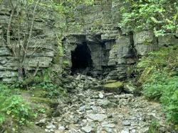
Boho Cave is a classic example of maze cave development in the Cherty Facies of the Dartry Limestone and is the only example of this cave type in Northern Ireland. The estimated 1500m of joint controlled passage is developed horizontally within an area of 4000m2. Within the system there is an active phreatic zone, a series of episodic passages and areas of abandoned passage which host good speleothem deposits in places. Boho Caves are the seventh longest system in Northern Ireland. Within the Boho Quarry and Ravine area are episodic surface rivers, an episodic waterfall, a limestone gorge, and river bed and bank risings which together with the caves create an excellent suite of karst features. Pollnagollum Coolarkan Cave is a large (8m wide by 6m high) relict cave passage 100m long which has been re-invaded by a small stream. Many speleological features can be seen in this easily accessible cave. | |
| Introduction: | |
The Boho area includes approximately 16km2 of upland bisected by a river valley. The catchment is bounded to the north by the Reyfad - Carrickbeg area and the Aghanaglack upland, to the west by Ora Beg and the Dooletter col, and to the south by the summit ridge of Belmore Mountain. The karst area is limited to 3-4km2 in the Aghanaglack river valley and Boho Cave to an even smaller are a (4000m2) at Boho Village. Pollnagollum Coolarkan Cave is an isolated site situated on the north flank of Belmore Mountain. History of Cave Exploration: The area around the village of Boho has two main sites of interest to speleologists, Pollnagollum Coolarkan and Boho Caves. Jameson visited Coolarkan during his cave explorations with Martel in 1895. He reported to Martel who commented clearly in 'Irelande et Cavernes Anglaises' that "a cave (Coolarkan) which he reckoned to be 300 to 400m long, and which, being pierced by two openings showed the peculiarity of being penetrable from end to end". If this was the case no further description was made of Pollnagollum Coolarkan until one entrance had collapsed. It is, however, possible that this description refers to Boho Caves. Boho quarry, in which there are a number of entrances to the caves, was active until the mid 1950's and many local people would have explored short sections of the cave during and before this time. 'Tourists' of the nineteenth century are reputed to have been directed to Pollnagollum Coolarkan as a site of local interest. The Yorkshire Ramblers explored Boho Caves in 1907 but it was not until the mid 1960's that a survey of this complicated system was attempted by Dublin cavers. Major speleological sites: Boho Caves (sink H1268 4431), Pollnagollum Coolarkan (H1221 4311). Minor speleological sites: Aghanaglack Cave (H108 436) Scheduled monument Ferm 210: 57., Aghanaglack Rising (H1088 4343), Pollkerran (H1183 4513), Pollbeg (H1175 4558). Approximate catchment area of Boho: ~16km2. Total surveyed cave: ~1.5m. | |
| Description: | |
I - Hydrology The catchment area for the Boho karst unit is large (16km2) in comparison to the neighbouring units (Noon's Hole - Arch Cave 3.5km2, Reyfad - Carrickbeg 9km2). A dendritic drainage system brings allogenic water from the sandstone uplands to the north, west and south into the Aghanaglack River valley. Within the catchment are a number of small loughs including Lough Naweelan, Dooletter Lough and Lough Blocknet. At the contact between the sandstones-shale cap and the Dartry Limestone the river bed is heavily guarded by clastic sediments and the water does not sink immediately. In normal water conditions the water sinks in the river bed between 30m and 100m upstream of the cave entrance (95m amsl). In these conditions the water is assumed to enter an impenetrable active phreatic zone which resurges in the river bed approximately 100m downstream of the waterfall in the Boho Ravine (70m amsl) close to the Dartry - Glencar Limestone contact. Along the Aghanaglack River, downstream of the Boho Ravine, are four river bank risings. Two on the southern bank have been dye traced from Pollnagollum Coolarkan Cave (McKay, 1989) and the two north bank risings are postulated to bring water from Pollkerran and Pollbeg. It is also possible that water from Pollmore drains to these risings and not to Carrickbeg. In wet conditions large flood pulses, of several metres form in the Aghanaglack catchment and are directed to Boho caves, a small block of limestone in comparison to the large catchment. The dry river bed leading from the Quarry Entrance, including the normally dry waterfall, become active in these conditions. Tracing has shown that during flood a mixture of water from the Aghanaglack River and the Pollnagollum Coolarkan stream flows from Tullyholvin Rising. This flood water follows a normally dry surface river bed and joins the Aghanaglack River in the Ravine. The 'folk' rising for Pollnagollum Coolarkan water at Mullaghdun on the south side of Belmore Mountain was disproved by McKay (1989). II - Underground Karst Major Speleological Sites: (i) Boho Cave System The Boho Cave System is an extensive horizontal joint controlled maze cave developed in the Cherty Facies of the Dartry Limestone. The joint sets are approximately at right angles, one oriented N-S and the other E-W. In the area of Boho Caves the bedding dips gently to the west. Fissures in both main orientations have been enlarged, but the N-S development predominates. All the passages in the system are characterised by chert bands which in many areas have been etched, leaving them as protruding ledges. There are at least seven entrances to the main areas of cave but the Quarry Entrance and the episodic sink of the Aghanaglack River are the largest and are those commonly used to gain access to the system. From the episodic sink there are a number of constricted routes leading north into a series of fossil chambers (Formation Passage and Coleraine Chamber) which contain the best calcite speleothems in the system. There are good examples of straws, stalactites, stalagmites, soft calcite, flowstone, curtains, gour pools and canopies which are developed on roof, walls and on a floor of medium to fine clastic sediment infill. Some flowstone canopies have sandstone pebbles cemented into exposed undersides. Coleraine Chamber is a large breakdown area and through the boulders of the floor the episodic zone can be reached. To the west Flush Passage and the Sewerage System are also part of the episodic zone and there are some breakdown chambers such as Henry's Hall. The main open passage from the episodic sink leads via fine phreatic tubes, areas of pebble and cobble banks and cherty rifts to the Quarry Entrance, which is the flood rising. This route takes a large amount of the flow during flood. To the south is a complicated area of opened cross joints leading to the Field Shakeholes and the Southern Series, while to the north of the main passage lies the Virgin Circuit. This area has another group of breakdown chambers which are inundated during flood. Organic debris gathers among the breakdown which chokes the chamber floors and fine sediment banks are also present in which charcoal layers are seen. A number of enlarged joints are now infilled with clastic sediments. Soft calcite deposits are common in the Virgin Circuit chambers and there are also gour pools, straw stalactites and a number of other speleothem deposits. In the Ravine are two short sections of cave, the Upper and Lower Ravine Caves. (ii) Pollnagollum Coolarkan This is a large isolated passage developed in Cherty Facies situated in forestry on the north flank of Belmore Mountain. A small stream with a catchment of 1.6km2 drops over the south edge of a collapse doline and enters the 7m wide 2m high entrance. One hundred metres of south trending passage attains widths up to 8m and heights of 10m at avens in the roof. Towards the terminal choke, the roof is developed on a prominent bedding plane dipping 10° to the south. Roof collapse has occurred in the largest part of the passage and forms a boulder pile adjacent to the east wall. There are a number of areas of straw stalactites on the cave roof and small areas of calcite gours and pools on the sediment floor. There are also remnants of a calcite false floor on the passage walls. The terminal choke is only inundated during flood as the stream sinks into impenetrable passage on the east wall or into the stream bed in drier conditions. Minor speleological sites: Pollkerran is a collapse doline developed in the Carn Limestone and takes a small stream. The blue-grey shaley mudstone beds of the Carn Limestone are well exposed in the doline walls. Pollbeg is a small sink which backs up in wet weather. Aghanaglack Cave is a scheduled historic monument. It is a natural cave, part of which has been modified for use as a souterrain. Aghanaglack Rising Cave has 18m of crawling passage which ends in a sump. III - Surface karst The surface karst of the Boho area are limited to the features in the Boho Ravine, with the exception of the Pollkerran and Pollnagollum Coolarkan collapse dolines. The dry stream bed and dry waterfall down stream of the Boho Cave Quarry entrance become impressive active features in flood. Further downstream, the stream bed, stream bank rising and Tullyholvin flood rising are impressive karst features. The Ravine Cave entrances are classic joint controlled rifts in cherty limestone which are only active in flood. | |
| Importance: | |
This small karst unit fed from a relatively large catchment is the only example of a joint controlled maze cave in Northern Ireland. Boho Caves display a number of unique lithological and structural controls on speleogenesis. The surface karst features of the Ravine and the roost of approximately fifty Daubenton's bats in the Upper Ravine Cave contribute further to the significance of this unique site. Pollnagollum Coolarkan is an important part of the Boho hydrological system and contains extensive sediment deposits which may contain important palaeoenvironmental information. | |
| Interpretation: | |
I - Hydrology The large delayed flood pulses which occur in the Boho karst are probably enhanced by the presence of loughs within this large catchment. When the loughs overflow in flood conditions, they feed large pulses into the system. The phreatic zone of the karst unit is unable to accommodate this increased flow and the episodic passages become active. The water chemistry (McKay, 1987) at Tullyholvin Rising indicates that the Pollnagollum Coolarkan and Aghanaglack water must mix in the phreatic zone, probably to the southwest as the Dartry Limestone - Glencar Limestone contact dips in this direction. II - Underground Karst Large flood pulses applied to a single point in a karst unit have been a dominant factor in the development of the maze caves of Boho. The other major contributing factor in the speleogenesis of Boho Caves is the high frequency of fissures in the limestone. Steep hydraulic gradients are created by floods and the inter- linked fissures are penetrated rapidly to relieve the pressure, resulting in numerous routes developed through the limestone block. The routes taken by the water through what are now episodic passages are often interrupted by clastic and organic debris which intermittently blocks some passages and continually redirects erosion. Evidence of present day organic blockages are seen in the Virgin Circuit and calcite false floor remnants and canopies are evidence of reworked sediments. The strong air flow between the numerous cave entrances is probably contributory to the soft calcite development seen in many areas of the cave. Remnants of cave (e.g. Aghanaglack Cave) on the southerly flanks of the Aghanaglack valley may represent fossil sinks which may have connected to the main cave system down valley. Pollnagollum Coolarkan is a large reinvaded fossil cave with extensive sediment infill. The cave has been choked by sediment deposition against a collapse area beneath a large surface doline. Brook (1971) suggests that Coolarkan formed as an ice edge sink, taking water from an ice sheet which filled the Aghanaglack Valley. III - Surface Karst The dry river beds and waterfall on the Aghanaglack river are the result of the water re-routing via a relatively immature phreatic zone below. | |
| Conclusions: | |
CONCLUSION The Boho area has been demonstrated to contain surface and underground karst features which are of significant karst geomorphological and geological interest and quality. There is also an important bat population associated with the caves. | |
| Notes: | |
For site specific information see; Key Site 385 - Boho Caves Sink Key Site 386 - Pollnagollum Coolarkan Key Site 387 - Aghanaglack Cave Key Site 388 - Aghanaglack Rising Key Site 389 - Pollkerran Key Site 390 - Pollbeg. For information and reference lists on the systems and features of other karst areas within the Belmore, Ballintempo and Tullybrack Uplands see; Key Site 1158 - Belmore Key Site 1160 - Reyfad-Carrickbeg Key Site 1161 - Noon's Hole-Arch Cave Key Site 1162 - Knockmore-Pollaraftra. BIOLOGICAL INTEREST The main biospeleological interest in the Boho area is the population of approximately 50 Daubenton's or Water bats which roost in the Upper Ravine Cave (McCann pers. comm.). Lass of Nottingham University (in Hazelton, 1974) made extensive faunal collections in Boho Caves and Pollnagollum Coolarkan which included the identification of the troglobitic Collembolan (Schaefferia emucronata) from Boho. Chapman (1993) cites the collection of a Stickleback (Gasterosteus aculeatus) from Boho and the Field Shake Holes and Southern Series have been observed to support a large spider population (Meta menardi). The strong draughts may bring trogloxenes into the cave on which this population thrives. | |
| Keywords | |
|---|---|
| Minerals: | Calcite |
| Rocks: | Chert, Limestone, Shale |
| Structures: | bedding, fault, joints, rift |
| Geomorph: | breakdown, clastic sediments, doline, drift, flowstone, gour pool, maze cave, organic sediments, sinkhole, soft calcite, speleothem, stalactite, stalagmite, straw |
| Measurements | |||||
|---|---|---|---|---|---|
| Length: | ~1500 m | Width: | Height: | ||
| Depth: | Area: | 4000 m2 | |||
| Access | |
|---|---|
| Planning: | HISTORY OF EXPLORATION The area around the village of Boho has two main sites of interest to speleologists, Pollnagollum Coolarkan and Boho Caves. Jameson visited Coolarkan during his cave explorations with Martel in 1895. He reported to Martel who commented clearly in 'Irelande et Cavernes Anglaises' that 'a cave (Coolarkan) which he reckoned to be 300 to 400m long, and which, being pierced by two openings showed the peculiarity of being penetrable from end to end'. If this was the case no further description was made of Pollnagollum Coolarkan until one entrance had collapsed. It is, however, possible that this description refers to Boho Caves. Boho quarry, in which there are a number of entrances to the caves, was active until the mid 1950's and many local people would have explored short sections of the cave during and before this time. 'Tourists' of the nineteenth century are reputed to have been directed to Pollnagollum Coolarkan as a site of local interest. The Yorkshire Ramblers explored Boho Caves in 1907 but it was not until the mid 1960's that a survey of this complicated system was attempted by Dublin cavers. |
| Management: | |
The Boho Quarry and Ravine are owned and managed by Fermanagh District Council. The upstream episodic sink entrance has been modified by the installation of a flood debris grill as part of a water course management programme. There is also a dam at this sink which is presumed to have been built as a silt trap for commercial use or for water course management. The Fermanagh Environmental Impact Group undertook a rubbish removal programme in the Ravines and cave, a refencing of the site and some minor woodland management, during the early 1990's, which has largely restored the quality of the site. Both the Boho Caves area and Pollnagollum Coolarkan are accessible to casual visitors and are promoted in some tourist guide books as sites of interest. There is also an aspiration in the local community to 'develop' the caves for visitors. There are both conservation and safety implications in such proposals. Internal threats: The episodic passages of the Boho Caves can be classified as high energy and the relict areas as medium to low energy. The main high energy passages are regularly used by education and adventure caving groups but as the access to the speleothem rich abandoned areas is via tight cave passage these groups do not visit them. The flood inundation has brought household and farm debris into the cave in the past but the problem is not as significant today. The easily accessible passages from the Quarry Entrance to the Main Sink has suffered graffiti from casual visitors in the form of large painted arrows on the cave walls. Pollnagollum Coolarkan is medium to high energy cave passage and is also regularly used by caving groups. As the passage is easily accessible, relatively easy and short (and the small areas of speleothems are generally out of reach) the cave provides a good facility for speleological education. External threats: It appears that large scale dumping of rubbish in the Ravine at Boho has stopped, however, debris dumped in the river above the cave system is washed into the cave. The flood debris grill, which is cleared regularly, stops the majority of large items. There are a number of houses and roads directly above the Boho Cave system and there are numerous houses, farms and large areas of forestry in the catchment. Leaching of effluent above the caves could affect the speleothems in the abandoned areas and the water quality in the cave. Effluent discharged into the river and drainage changes in the catchment could also affect the cave. Sporadic quarrying activity at Coolarkan Quarry still takes place and should the face closest to the doline be worked there would be a threat to the site. Aghanaglack Cave has been blocked during construction of a private road and is inaccessible. | |
| Threats: | Dumping; leaching of household and farm effluent; some quarrying. |
| Uses | |
| Potential: | Further investigation of the hydrology of the catchment is of significance to Northern Irish speleology. The clastic sediments of both Boho and Coolarkan caves will contain abundant information on the paleoenvironments of the area. There is great potential for further exploration in the area both in extending the Boho system and in gaining access to the link between Pollnagollum Coolarkan and Tullyholvin. |
| References (28) | |||
|---|---|---|---|
| Adair, F., 1974. Notes on the distribution and behaviour of the cave spider, Meta menardi (Latr.) in Ireland (Araneae Argiopidae). Irish Naturalists Journal, vol. 18 pt. 2, pp.40-41. | |||
| Barnes, S., 1994. Preliminary Hydrological Investigation of the Area between Carnlough and Waterfoot, County Antrim, Northern Ireland. (Thesis) University of East Anglia. | |||
| Boon, M., 1977. Down to a Sunless Sea. | |||
| Brook, D., 1971. Notes on the Reyfad Area. University of Leeds Speleological Association Review, numb. 8. | |||
| Clark, S., 1975. Hull University Speleological Society Expedition to Northern Ireland 1975. Hull University Speleological Society. | |||
| Coleman, J., 1965. The Caves of Ireland. Anvil Books, Tralee. | |||
| Drew, D.et al., 1977. Caves and Karsts of Ireland. In 7th International Speleological Congress British Cave Research Association. | |||
| Fletcher, T.P., 1977. Lithostratigraphy of the Chalk (Ulster White Limestone Formation) in Northern Ireland. Report of the Institute of Geological Sciences, vol. 77/14. | |||
| Gunn, J., 1985. Water Tracing in the North Cuilcagh Karst. Irish Speleology, vol. 3 pt. 2. | |||
| Halliwell, R.A., 1970. An Elementary Study of the Cave Morphology and Seepage in the Reyfad-Pollnacrom System. Transactions of the Cave Research Group of Great Britain, vol. 12 numb. 4. | |||
| Hazleton, M., 1973. Irish Hypogean Fauna and Irish Biological Records 1856-1971. Transactions of the Cave Research Group of Great Britain, vol. 15 numb. 4. | |||
| Hopkirk, A., 1994. The Search for Bat Hibernacula in Ireland. The Leisler. Magazine of the Northern Ireland Bat Group, vol. 1994 numb. Spring. | |||
| Jameson, H.L., 1896. On the Exploration of the Caves of Enniskillen and Mitchelstown for the R.I.A. Flora and Fauna Committee. Irish Naturalists Journal, vol. 5, pp.93-100, plates 1. | |||
| Jones, G.Ll. & McKeever, M., 1987. Sediments and Palynology in Marble Arch Cave. Cave Science, vol. 14 numb. 1. | |||
| Kelly, J.G., 1989a. The late Chadian to Brigantian Geology of the Carrick-on-Shannon and Lough Allen Basins, North West Ireland. (Thesis) N.U.I. | |||
| Kelly, J.G., 1989b. Geology and Caves of Cuilcagh Mountain, Counties Fermanagh and Cavan. Irish Speleology, vol. 13. | |||
| Kelly, J.G., 1990. Reyfad Pot. Irelands Deepest (and Longest?) Descent 96. | |||
| Kelly, J.G., 1995. The Asbian Geology of Cuilcagh Mountain Area, Co's Fermanagh and Cavan, Ireland. Initiation, growth and decline of a tectonically controlled carbonate ramp. In European Dinantian Environments II. | |||
| Legg, I.C., Johnston, T.P., Mitchell, W.I. & Smith, R.A., 1995. Geology of the country around Derrygonelly and Marble Arch. Memoirs of the Geological Survey Northern Ireland, vol. Sheet 44,56,43. | |||
| Magennis, P., 1874. The Ribbon Informer. A Tale of Lough Erne. Frederick Bell and Co. | |||
| Martel, E.A., 1897. Irelande et Cavernes Anglaises. Libraire ch. Delagrave., Paris. | |||
| McKay, S., 1987. The Chemical Differentiation of Carbonate Aquifers in the Karst of North-West Ireland, with a view to predicting the type and length of cave system under Belmore Mountain. (Thesis) University of Bristol. | |||
| McKay, S., 1989. A study of Carbonate Aquifers in the Karst of North West Ireland. Irish Speleology, vol. 13. | |||
| Mitchell, W.I., 1983. High grade Dolomite deposits in the Belcoo - Boho area of County Fermanagh. (Unpublished Report) Geological Survey of Northern Ireland Open File Reports, vol. 68. | |||
| Nichols, A., 1970. Cambridge University Caving Club Expedition to Ireland, 1970. Cambridge University Caving Club. | |||
| Oswald, D.H., 1955. The Carboniferous Rocks between the Ox Mountains and Donegal Bay. Journal of the Geological Society of London, vol. 111, pp.167-186. | |||
| Sheridan, D.J.R., 1972. Upper Old Red Sandstone and Lower Carboniferous of the Slieve Beagh Syncline and its setting in the northwest Carboniferous basin, Ireland. Special Papers of the Geological Survey of Ireland, vol. 2, pp.1-120. | |||
| Williams, P.W., 1970. Limestone morphology in Ireland. In Irish Geographical Studies, pp.105-124 Queens University of Belfast. | |||
| Map(s): | The specific areas are marked on 1:10,000 sheet 210 and labelled as: B.1. Boho Caves. B.2. Pollkerran. B.3. Pollnagollum Coolarkan. | ||
| Record type: | ESCR report | ||
| Entered by: | E M Porter | ||
| Last updated: | 23 Dec 2003 | ||
| Enlander, I., Dempster, M. & Doughty, P., 2026. Belmore, Ballintempo & Tullybrack Uplands; Boho, County Fermanagh, site details. [In] Earth Science Conservation Review. https://www.habitas.org.uk/escr/site.php?item=1159. Accessed on 2026-11-04. |
| Previous Site | Next Site |