
| Previous Site | Next Site |
Earth Science Conservation Review
| Ballyrainey | Down |
| Site number: | 1195 | ||
| ESCC: | EO | ||
| Locality Type: | Stream section | Status: | local interest |
| Grid Reference: | J455722 Centroid | ||
| Google maps: | 54.57757,-5.7498 | ||
| County: | Down | Council area: | Ards & North Down Borough Council |
| Period: | Permian | ||
| Stages: | Upper Permian | ||
| Lithostrat: | Belfast Group, Newforte Breccia Formation | ||
| Site Description | |
|---|---|
 | |
| Highlights: | |
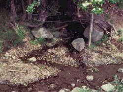
The poor exposures in the stream marking the boundary of Ballyrainey townland, are the only outcrops of the Newforte Breccia Formation. | |
| Introduction: | |
Of the Permian strata found in the Newtownards Trough and the Belfast Basin, only the Newforte Breccia Formation is exposed, albeit poorly in the Ballyrainey section. The other formations are known from boreholes at Avoniel, Belfast (J361 739), Ballyalton near Newtownards (J464 728), Belfast Harbour (J378 784), Haw Hill near Comber (J483 695) and Kennel Bridge near Comber (J454 700). The exposures at Ballyrainey, 3km north of Comber, occur along a 500m section south of Newforte, in the stream marking the boundary of Ballyrainey and Ballymagreehan townlands. The type section for the Newforte Breccia Formation is 53.04m thick and was recorded in the Ballyalton Borehole (Bazley, 1975) and defined by Smith et al. (1991). In the borehole, the Newforte Breccia with a marly matrix overlies the Coolbeg Breccia and is conformably overlain by the Sherwood Sandstone Group. Since there are no red mudstone or evaporite beds in the borehole, in contrast to the Upper Permian of the Belfast Basin, the Newforte Breccia Formation is regarded as representing a complete section through the Belfast Group and is correlated with the Haw Hill Borehole Formation farther south. This correlation requires strong facies changes across the Newtownards Trough in Upper Permian times. | |
| Description: | |
The exposures at Ballyrainey are very poor. The breccia contains predominantly Lower Palaeozoic greywacke sandstone and mudstone fragments set in a reddish purple silty marl or mudstone matrix, with greenish reduction patches. The rock fragments are up to 0.2m in length and tend to be aligned within a weak bedding fabric. There are sporadic reddish grey sandstone interbeds up to 0.15m thick. The breccia has specular haematite crystals on joint surfaces and scattered vugs, partly infilled with quartz or calcite. | |
| Importance: | |
These are the only exposures of the Newforte Breccia Formation and are thus of local importance in terms of the Permian stratigraphy of Northern Ireland. | |
| Interpretation: | |
Prior to the drilling of the Avoniel and Ballyalton boreholes, the age of these breccias near to Scrabo was assumed to be Triassic (GSI, 1869). The presence of Upper Permian Magnesian Limestones in the Avoniel borehole overlying a 44.5m thick sequence of sandstones and brockram (now interpreted as the Coolbeg Breccia Formation), and the presence of well rounded, presumably wind transported grains in the breccias of the Ballyalton Borehole, has led to a re-interpretation of these sediments as Permian in age. In the Ballyalton Borehole an upper unit of breccias with a marl dominated matrix (Newforte Breccia) overlies breccias with a sand dominated matrix (Coolbeg Breccia). As these sediments at Ballyrainey have a marl dominated matrix, they are Newforte Breccia and are assumed to be Upper Permian. | |
| Conclusions: | |
The breccias which outcrop at Ballyrainey are the only examples of Upper Permian breccias in Northern Ireland which can be examined. They are therefore of local importance and should be preserved. | |
| Notes: | |
For information on other Permian sites see Key Site 17 - Cultra Key Site 1196 - Drumarg. For general information on the Permian System in N. Ireland see Key Site 1191 - The Permian System in N. Ireland - Introduction. | |
| Keywords | |
|---|---|
| Rocks: | Breccia, Greywacke, Sand, Sandstone |
| Measurements | |||||
|---|---|---|---|---|---|
| Length: | 500 m | Width: | Height: | ||
| Depth: | Area: | ||||
| Access | |
|---|---|
| Approach: | 3km north of Comber. Access to the sites is easiest from Newforte Farm. |
| Management: | |
Lying in a small stream in agricultural land, these exposures are most at risk from drainage improvements. | |
| Uses | |
| Uses: | Agricultural land. |
| References (2) | |||
|---|---|---|---|
| Bazley, R.A.B., 1975. The Tertiary Igneous and Permo-Triassic rocks of the Ballyalton Borehole, County Down. Bulletins of the Geological Survey of Great Britain, vol. 50, pp.71-90. | |||
| Smith, R.A., Johnston, T.P. & Legg, I.C., 1991. Geology of the country around Newtownards Memoirs of the Geological Survey Northern Ireland, pp.42 PP. | |||
| Map(s): | Geological Survey of Ireland (1869) 1:63,360 Geological Sheet 37 (Newtownards). | ||
| Record type: | ESCR report | ||
| Entered by: | E M Porter | ||
| Enlander, I., Dempster, M. & Doughty, P., 2026. Ballyrainey, County Down, site details. [In] Earth Science Conservation Review. https://www.habitas.org.uk/escr/site.php?item=1195. Accessed on 2026-11-05. |
| Previous Site | Next Site |