
| Previous Site | Next Site |
Earth Science Conservation Review
| Ballysudden, Cookstown | Tyrone |
| Site number: | 280 | File Number: | H87 |
| ESCC: | EA | ||
| Locality Type: | Quarry (working) | Status: | ASSI |
| Grid Reference: | H8075 Centroid | ||
| Google maps: | 54.61731,-6.76163 | ||
| County: | Tyrone | Council area: | Mid Ulster District Council |
| Period: | Carboniferous | ||
| Stages: | Asbian, Brigantian, Visean | ||
| Lithostrat: | Armagh Group, Rockdale Limestone Formation | ||
| Site Description | |
|---|---|
 | |
| Highlights: | |
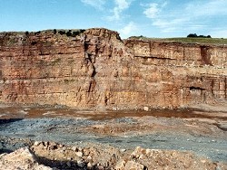
The Cement Works Quarry at Cookstown exposes over 100m of strata in a continuous, if slightly faulted, section. Shallow water limestones are interbedded with thin, lenticular sandstones and numerous, often spectacular, palaeokarst features. Fossils indicate an Asbian-Brigantian age for the sequence. | |
| Description: | |
The Cement Works Quarry is located 3km SSW of the centre of Cookstown on the east side of the C-class Sandholes Road. Strata in the quarry are inclined at between 12-15 deg. to the north and NNE. The succession is broken up by minor NE-SW and NW-SE orientated faults. Regardless of this fact there are a sufficient number of distinctive horizons and minor sedimentary cycles that allow a complete section of the strata in the quarry to be constructed. Detailed information about the composition of the overall bulk of the limestones is not included, although these data are available to the GSNI. Significant horizons and minor cycle boundaries are however depicted on the partial vertical log of the quarry and illustrated photographically. All the palaeontological information presented for the Cement Works Quarry has been obtained by the GSNI. Exposures of Carboniferous strata in the area south of the main quarry occur only very rarely. However the drilling of numerous boreholes by the Company in and around the quarry has clarified the stratigraphy of these late Vis‚an strata. Natural outcrops of fine to coarse-grained grainstone/packstone occur at 2 localities just over 1km south of the quarry. These occur in Annaghananam (H7987 7363) and Annaghteige (H8046 7350) townlands and represent strata low in the sequence [HGL 7] proven by the Company boreholes. Both samples contain a rich microbiota of Asbian age but in addition the latter locality contains Archaediscus stage angulatus, bilaminar palaeotextulariids, the alga Koninckopora and in particular the foraminifera Mstinia, which indicates an early Asbian age. The oldest rocks in the Cement Works Quarry occur at the southern margin and form a low cliff below the main access ramp to the lowest level, and a long dip slope above and below this incline. The lowest strata exposed in the quarry consist of 2m of medium- to coarse-grained, purple-tinged, fawn sandstone. These are overlain by grey coarse-grained silty limestones, and 0.73m above the top of the sandstone is 0.14m of purple to dark grey shale. This caps the long dip slope that occurs at the southern side of the quarry complex and contains abundant brachiopods and coral debris. The brachiopods include large, inverted and 'right-way-up' specimens of latisimoid and tumid (with well- marked ears) Gigantoproductus. Corals, in particular colonies of Siphonodendron martini, are usually fragmented and solitary forms are juvenile, small specimens of Siphonophyllia sp. The south face of the quarry consists of thin to thick beds of medium to dark grey packstones and fine grainstones with very irregular bioturbated surfaces and thin (0.01-0.2m) dark grey to grey-green silty shales. The lowest 25m of strata may be divided into three units, each one consisting of marine limestones but capped by either grey, very fossiliferous shales or purple-red palaeokarstified limestones and palaeosol siltstones and shales. Within these strata the limestones contain abundant foraminifera and algae, unfortunately however not always diagnostic of age. This is particularly true of samples CTF1 and 2 which contain the foraminifera Koskinotextularia and are thus not older than Holkerian. However in view of the occurrence of an undoubted early Asbian microbiota in outcrop samples from older horizons (op. cit.), and the occurrence of bilaminar palaeotextulariids in CTF8 (located below CTF1 and 2, and 0.2m above the top of the basal sandstone in the quarry) all these strata are Asbian. Lying above these basal beds, samples CTF 3-7 all contain an undoubted Asbian microbiota but lack taxa that would indicate an assignment to either the early or late Asbian. The limestones, from which these samples were obtained, in particular CTF 7 are overlain by the lowest major palaeokarst horizon. This is ~4m thick and is bounded at the base and top by thin (0.1-0.2m) black shales. The intervening strata are extremely variable and include highly altered (palaeokarstic) rubbly limestones and red shales and, in the SE corner of the quarry, a 4m deep channel infilled with medium-grained, fawn (purple- stained) sandstone which truncates the basal black shale but is overlain by the top shale. The lowest microbiota of undoubted late Asbian age occurs above this horizon in sample CTF 10 and contains the first entry of Koskinobigenerina. The algae Koninckopora ranges throughout all of these strata up to and including CTF 13. The continued occurrence of Koninckopora is significant and confirms an Asbian age, as the alga is not known from Brigantian or younger strata. In the NE corner of the quarry, at its lowest level, is a spectacular example of a Carboniferous pothole. 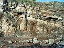 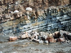 Lying below this 1.5m thick limestone bed is a mixed sequence of palaeokarst sediments, grainstones and sandstones. The lenticular shape of sandstone bodies at their margins is well illustrated on the east side of the quarry as is the discontinuous nature of some palaeokarst horizons. One example shows the palaeosol deposit infilling irregularities (? channels) in the top surface of the sandstone body and is itself overstepped and cut out by the base of the succeeding marine limestones consisting of white- cream, unbedded, shale-free, medium to coarse-grained oolitic grainstones. Fossils in the strata lying below the main pedogenic horizon (including the deep pothole) are dominated by the colonial corals Siphonodendron junceum, S. martini and S. pauciradiale but also include solitary forms such as Dibunophyllum bourtonense and Palaeosmilia murchisoni and large specimens of Gigantoproductus sp. Although sample CTF 13, from the base of the bed directly overlying this pedogenic horizon, does not contain diagnostic Asbian foraminifera, it is the highest level, in the Cookstown Quarry, at which Koninckopora is recorded. All the algal/foraminiferal assemblages that occur stratigraphi- cally above the level of CTF 13 (including CTF 14-24) are lacking Koninckopora and may be of Brigantian age. It is likely that the base of the 9m of strata that include sample CTF 14, and which consist mainly of sandstones, are of sequence stratigraphic significance and represent the Asbian-Brigantian boundary. Unfortunately whilst samples CTF 14-21 lack Koninckopora they also lack index taxa of the early part of the Brigantian. Lying stratigraphically between the pedogenic horizon, just below sample CTF 13, and a very distinctive sequence, consisting of ~6m of alternating thick limestones and dark grey silty shales, 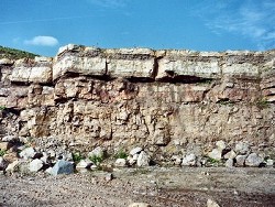 Intriguingly, despite the presumed early Brigantian age that is assigned to strata that include samples CTF 14-21, based on the absence of Koninckopora, rich faunas of corals and brachiopods in these same strata are also lacking Brigantian index taxa and contain assemblages that would otherwise be assigned to the Asbian, without the control of the 'diagnostic' foraminifera(?) and algae. Two examples of these assemblages are listed below. The 6m of very distinctive interbedded limestones and shales rest directly on over 4m of bedded grey packstones and contain a rich assemblage of corals and brachiopods (sample CT 8) including: CORALS - Aulophyllum redesdalense, Dibunophyllum bipartitum bipartitum, Lithostrotion portlocki, Siphonodendron pauciradiale, Siphonophyllia benburbensis BRACHIOPODS: Gigantoproductus inflatus The limestones consist of medium to dark grey packstones and oncolitic floatstones and the shales are conspicuously pyritous and silty and contain most of the solitary corals, large brachiopods and large crinoid ossicles. Strata lying above this limestone/shale unit occur in the north and NE part of the quarry and consist mainly of thin to thickly bedded limestones, in particular white to grey-fawn grainstones separated by thin purple-red shales. The effects of pedogenesis and the occurrence of palaeokarst surfaces become more evident towards the top of the quarry north face. Coral/brachiopod faunas (sample CT 5) collected from limestones 20m above the top of the 6m limestone/shale unit are still of Asbian affinities and are associated with abundant specimens of the microfossil Saccaminopsis. The corals include the species Dibunophyllum bourtonense, Siphonodendron junceum, Koninckophyllum vaughani and S. cf. martini The lowest macrofauna of undoubted Brigantian age (sample CT 6) is recorded in 0.15m of purple mudstone 4m above the Asbian fauna described above and 8m below the top of the north face of the quarry. This bed is only exposed in the NE corner of the quarry and contains the brachiopods Eomarginifera cambriensis and Gigantoproductus gigantoides, both characteristic of the early Brigantian. The characteristic early Brigantian colonial coral Diphyphyllum latiseptatum was also collected in the north face of the quarry, about 2.1m below the top of the sequence (sample CT 7). The first, and lowest, occurrence of undoubted Brigantian micro- fossils occurs in sample CTF 22, and also in samples CTF 23 and 24. The level of CTF 22 is also virtually coincident with the level of CT 6, the first occurrence of an undoubted Brigantian macrofauna, the vertical separation only amounting to about 1.5m of strata. All three samples (CTF 22, 23 and 24) contain Asterarchaediscus which first appears in the Brigantian. | |
| Interpretation: | |
The succession of lithologies in the Cement Works Quarry at Cookstown were deposited in shallow marine and subaerial environments. With the exception of the 6m thick limestone/shale sequence, from which samples CT 8 and CTF 17 were collected, which represents somewhat deeper water outer shelf conditions, the remaining limestones etc. represent a carbonate platform environment. Skeletal grainstones and oolitic and pisolithic limestones are all deposits that are associated with shallow agitated water. Subaerial exposure of the limestone seabed caused by rapid fluctuations in sea levels or by the effects of punctuated uplift or subsidence in the east Tyrone area occurred at every level of this sequence in Asbian and early Brigantian times. The characteristic purple-red-brown colours of these sediments are in stark contrast to the white-fawn or pale to medium greys of the marine limestones. Leaching of iron compounds during early diagenesis and at later times imparts purple-violet or pink staining to the surrounding limestones and marine shales. Subaerial exposure of the seabed surface allows the effects of pedogenesis and karstification to affect the limestones. Apart from processes of reddening bedding is usually severely disrupted and solution of the limestones, with time, causes the formation of potholes. Infill of these structures may be either with marine sediments, if covered by a transgression of the sea, by fluvial clastic debris if the land surface is crossed by river channels or by aeolian debris, blown in by prevailing winds. In most examples in the quarry the red-bed sediments form uneven, thin layers of fine-grained aeolian and pedogenic sediment which is unbedded. Fluvial channels infilled by sand debris occur only rarely and are lenticular in outline and discontinuous laterally. By far the most spectacular palaeokarst feature is the deep palaeo-pothole in the SE corner of the quarry. All the sediment filling this 15m (minimum) deep pothole is unbedded and fine- grained and was presumably transported to this area by wind. This palaeokarst surface clearly represents a considerable period of time in the latest Asbian when marine regression affected all of the east Tyrone carbonate platform and also (?) rocks of the same age and lithology in south Co. Armagh (see Subarea-6: Drumarg Cliff, Co.Armagh). The marine limestone that rests directly on top of this palaeo- karst surface is a pale grey grainstone that forms a single bed that varies from 0.06-1.55m thick, within a distance of ~100m. Because thicker sections of this bed do not occur directly above palaeo-potholes it seems likely that they were completely infilled by the time the marine transgression flooded the platform and thickness variations in this bed simply reflect an uneven sea-bed surface topography. | |
| Conclusions: | |
The Carboniferous outcrop in the Cement Works Quarry at Cookstown is the best section of the late Vis‚an (Asbian-early Brigantian) rocks of the Armagh Group in County Tyrone and Subarea-7, and probably of N. Ireland. The variety of lithologies representing a wide range of facies is remarkable and some of the sediment- ological structures preserved in the quarry are spectacular. | |
| Notes: | |
For information on other sites in Subarea-7 see Key Site 1180 - Subarea-7; Dungannon-Coalisland-Cookstown. | |
| Keywords | |
|---|---|
| Rocks: | Limestone, Sand, Sandstone, Shale |
| Fossil Groups: | Alga, Brachiopod, Coral, Crinoid, Foraminifera, Microfossil, Microfossils |
| Fossil List: | Gigantoproductus sp. , Koninckopora sp., Koskinobigenerina sp. , Koskinotextularia sp. , Palaeosmilia murchisoni , Siphonodendron junceum , Siphonodendron martini , Siphonodendron pauciradiale , Siphonophyllia sp. |
| Structures: | palaeokarst |
| Relations: | Aeolian sediment, Marine sediments |
| Paleoenv: | shelf |
| Access | |
|---|---|
| Approach: | 3km SSW of the centre of Cookstown on the east side of the C-class Sandholes Road. |
| Restrictions: | Access only with permission of Quarry Manager. |
| Map(s): | See 1:50,000 O.S. Sheet 13 (The Sperrins); GSNI (1983) 1:50,000 Solid Geology of Sheet 27 (Cookstown). | ||
| Record type: | ESCR report | ||
| Entered by: | Doughty, P.J. | ||
| Last updated: | 12 Jun 2004 | ||
| Enlander, I., Dempster, M. & Doughty, P., 2026. Ballysudden, Cookstown, County Tyrone, site details. [In] Earth Science Conservation Review. https://www.habitas.org.uk/escr/site.php?item=280. Accessed on 2026-11-05. |
| Previous Site | Next Site |