
| Previous Site | Next Site |
Earth Science Conservation Review
| Banagher Glen Quarry | Londonderry |
| Site number: | 143 | ||
| ESCC: | ED | ||
| Locality Type: | Quarry (disused) | Status: | ASSI |
| Grid Reference: | C669048 Centroid | ||
| Google maps: | 54.88686,-6.95751 | ||
| County: | Londonderry | Council area: | Causeway Coast & Glens Borough Council |
| Period: | Precambrian | ||
| Stages: | Dalradian | ||
| Lithostrat: | Dungiven Formation | ||
| Site Description | |
|---|---|
 | |
| Highlights: | |
This disused quarry contains massively bedded, coarse-grained limestone with fine examples of recrystallization textures, including distinctive black calcite crystals and graded bedding?. The limestone is interbedded in a succession containing metavolcanic and arenaceous metasedimentary lithologies which overall are typical of the Dungiven Formation. | |
| Introduction: | |
Banagher Glen Quarry is located on the left bank of the Owenrigh River, approximately 250m north-west of the old Banagher filter house for the Altnaheglish Reservoir. The site lies within the Department of the Environment Nature Reserve. Access to the site is via an overgrown footpath leading from the Car Park directly south of Cushcapal Bridge [C670 048] to the Owenrigh River. The quarry lies directly across the river from this point. On the first edition of the one inch to one mile geological, (Sheet 18, Dungiven) (Geological Survey of Ireland, 1884, Nolan et al., 1884) the Dalradian succession was referred to as "Altered Lr Silurian". Within this subdivision, several separate limestone units, including the unit that outcrops in Banagher Old Quarry, were shown striking ENE-WSW across the Owenrigh River. Hartley (1938) produced one of the earliest detailed lithostratigraphic maps of the Dalradian of the Sperrin Mountains and included the limestones at Banagher Glen within what he termed the "Dungiven Limestone Group". Currently these rocks are referred to as the Dungiven Formation, based on the stratigraphic definition of Arthurs (1976), see table below, (Geological Survey of Northern Ireland, 1997). The Dungiven Formation, together with the Torr Head Limestone Formation in NE Antrim, represents the topmost stratigraphic interval of the Argyll Group (Middle Dalradian) in Northern Ireland. Both formations have been correlated with limestones at comparable horizons in Donegal (Culdaff Limestone) and Scotland (Loch Tay Limestone) (Gower, 1972, Gibbons et al., 1994). TABLE TO BE ADDED Dalradian stratigraphy and ESCR sites in the northern Sperrin Mountains. | |
| Description: | |
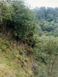
The limestone quarry at Banagher Glen originally had working faces up to 25m high. The quarry is now largely overgrown and most faces are partially obscured by scree and vegetation. The best exposed face is on the northern side of the quarry and is accessible, with care, across a fresh boulder scree. The rock is characteristically a grey or bluish grey coarse-grained recrystallized limestone. On weathered surfaces, variation in both colour and grain size define a clear lithological banding presumed to be bedding (S0, 110°/070°N). Some of the limestone units are extremely coarse-grained with black angular and intergrown calcite crystals up to 1cm diameter. Thin sections show this to be a brecciation texture with angular clasts of black graphitic calcite of varying sizes within a clear calcite vein-breccia matrix containing some detrital quartz. At the base of the north face of the quarry, limestone is interbedded with thin partings of quartz rich psammitic schist. The northern limit of the limestone appears to be marked by a skarn-like contact with massive metabasite at the foot of the quarry face. Outcrops here are very overgrown, but it does seem likely that this metabasite represents a continuation of a pillow lava unit which outcrops in the east bank of the Owenrigh River in the vicinity of Cushcapel Bridge [C671 048]. | |
| Importance: | |
This site has national significance because it contains the best examples of coarse brecciated limestone with sedimentary structures and black calcite within the Dungiven Formation. This site will feature in a study currently being planned by the Geological Survey of Northern Ireland and the British Geological Survey. This work will investigate the provenance of Dalradian limestones in Northern Ireland and Scotland and, depending on the outcome, the site may prove to have international significance for establishing correlations with the Dalradian succession in Scotland and elsewhere in Ireland. | |
| Interpretation: | |
Throughout Ireland and Scotland, the Argyll Group (Tayvallich Subgroup), including the Dungiven Formation, represents a period of important change and transition within the Dalradian. During this period, the continental crust at the margin of Laurentia was under the influence of a developing extensional tectonic regime and the comparatively stable shelf depositional environments which had characterised much of Lower and Middle Dalradian times, gave way to less stable conditions. Crustal extension and thinning was accompanied by a major upsurge in volcanic activity and the eruption of basaltic lavas into comparatively shallow near-shore marine sedimentary environments. This resulted in the intimate association of quartzite, quartz-wacke, limestone, basaltic pillow lavas and tuffaceous (volcaniclastic?) sediments, which is so characteristic of the Dungiven Formation. Gower (1972) interpreted the black calcite crystals at Banagher Quarry, as graded clasts which indicated "right way up" and younging towards the north. He suggested that these strata represented a sequence of turbidite units which grade from coarse sharp bases with abundant black calcite (up to 80%) to a finer grained top (40% black calcite). These units are in turn overlain by parallel laminated grey to white limestone then thin unlaminated limestone. However, textural evidence from a thin section (No. AV388) indicates that the coarse-grained black calcite crystals are brecciated limestone rather than lithic clasts and that an early post-diagenetic pre-metamorphic brecciation event disrupted the limestone beds which included black (graphitic) laminae. Such disruption could conceivably have resulted from crustal upheavals linked to contemporaneous volcanic activity in the Dungiven Formation. During late Caledonian times, the entire Dalradian succession in the Sperrin Mountains was deformed, folded and subjected to regional metamorphism. The mineralogy of the limestones which contain black graphitic calcite, white calcite, quartz and phlogopite is consistent with metamorphism in the quartz-albite-epidote-biotite sub-facies of the Greenschist Facies. Structurally this site and the Dungiven Formation as a whole, lie close to the core of the Sperrin Overfold. This structure has a generally NE to SW axial trend and plunges gently towards the NE. Although no conspicuous cleavage or tectonic fabric is visible at outcrop at this site, in thin section (No. AV388) fresh, well-formed, tabular grains of porphyroblastic? albite have long axes which are consistently orientated approximately perpendicular to the primary banding (bedding) as defined by the graphitic bands. | |
| Conclusions: | |
This site contains sedimentological features which are unique within the Dungiven Formation. It is of undoubted national and potentially international interest. It is also predicted that this site will play an important role in forthcoming comparative studies between Dalradian limestones in Northern Ireland and Scotland. | |
| Notes: | |
For site specific information and references on other Dalradian sites in the Sperrin Mountains, Londonderry and Tyrone see the following sites: For Central and Southern Sperrin Mountains: Key Site 130 - Butterlope Glen Key Site 131 - Craig Key Site 132 - Mullaghcarbatagh Key Site 133 - Henry's Bridge, Glensass Burn Key Site 134 - Oughtboy Burn Key Site 135 - Garvagh Burn Key Site 136 - Barnes Gap Key Site 137 - Barnes Burn Key Site 138 - Golan Burn Key Site 139 - Glendarragh Burn, Glenlark Key Site 140 - Mountfield Old Quarry Key Site 141 - McNally's Burn, Broughderg For North Sperrin Mountains and Londonderry: Key Site 142 - Letterbrat Quarry Key Site 144 - Strabane Quarry Key Site 145 - Glenmornan River, Artigarvan Key Site 146 - Balix Hill Key Site 147 - Drain Quarry Key Site 148 - Kildoag Quarry Key Site 149 - Loughermore Mountain Key Site 150 - Burntollet and Tamnymore Wood Key Site 151 - Dog Leap, Limavady Key Site 152 - Kittybane Quarry Key Site 153 - Prehen Quarry Key Site 154 - Creevagh Hill Old Quarry For site specific information and references on other Dalradian sites in North-east Antrim see the following sites: Key Site 155 - Benvan Key Site 156 - Escort Port Key Site 157 - Torr Head Key Site 158 - Altmore Burn Key Site 159 - Leckpatrick Point Key Site 160 - Carnaneigh Key Site 161 - Loughan Bay Key Site 162 - Loughareema Channel Key Site 163 - Knocknacarry Bridge Key Site 164 - Cushendun Bay and Rock Port For general information on the Dalradian rocks of Northern Ireland see the following site: Key Site 124 - The Dalradian Rocks of Northern Ireland For general and site specific information on the Pre-Dalradian rocks of Northern Ireland see the following site: Key Site 123 - The Pre-Dalradian Rocks of Northern Ireland For general information and an extensive reference list on the Precambrian of Northern Ireland see the following site: Key Site 122 - An Introduction to the Precambrian of Northern Ireland | |
| Keywords | |
|---|---|
| Minerals: | Calcite |
| Rocks: | Limestone |
| Access | |
|---|---|
| Management: | |
The site lies within the area of the Department of the Environment's Nature Reserve in Banagher Glen. The quarry is overgrown but has so far not been used as a tip. It is possible that the site could in the future be considered for further extraction of limestone, or less likely as a landfill. If so, care should be taken to preserve the outcrops of interest at the northern side of the quarry where the best examples of the coarse-grained black calcite limestone breccia are located. Outcrops of the very coarse-grained black calcite lithology are comparatively rare even at this site, consequently, restricting hammering is recommended. It should however still be possible to collect representative materials from the fresh boulder screes at the base of the Northern face of the quarry. Attention should also be drawn to some safety aspects of this site. Since access to the site as described involves crossing the Owenrigh River, extreme caution should be exercised while crossing the river especially during times of high flow. Working in quarries is always potentially hazardous, and this one is no exception. Some of the screes and faces on the northern side of the quarry are very unstable. Extreme care and discretion should be exercised when approaching these outcrops. |
| References (5) | |||
|---|---|---|---|
| Arthurs, J.W., 1976a. The geology and metalliferous mineral potential of the Sperrin Mountains area Geological Survey of Northern Ireland Special Report. | |||
| Gibbons, W. & Harris, A.L.(eds), 1994. A revised correlation of Precambrian rocks in the British Isles Geological Society of London Special Report, numb. 22. | |||
| Gower, P.J., 1972. The Middle-Upper Dalradian Boundary with special reference to the Loch Tay Limestone (Thesis) Unpublished PhD thesis, University of Liverpool. | |||
| Hartley, J.J., 1938. The Dalradian rocks of the Sperrin Mountains and adjacent areas in Northern Ireland Proceedings of the Royal Irish Academy, vol. 44 pt. B. | |||
| Nolan, J., 1884. Explanatory memoir to accompany Sheet 26 of the maps of the Geological Survey of Ireland Memoirs of the Geological Survey of Ireland. | |||
| Map(s): | GSI (1884). 1:63,360 Geological Sheet 18 (Dungiven), Dublin, OS for GSI GSNI (1997). 1:250,000 Northern Ireland, Solid Geology (2nd edition), BGS, Keyworth, Nottingham | ||
| Record type: | ESCR report | ||
| Entered by: | E M Porter | ||
| Enlander, I., Dempster, M. & Doughty, P., 2026. Banagher Glen Quarry, County Londonderry, site details. [In] Earth Science Conservation Review. https://www.habitas.org.uk/escr/site.php?item=143. Accessed on 2026-11-05. |
| Previous Site | Next Site |