
| Previous Site | Next Site |
Earth Science Conservation Review
| Cloghfin Port, Island Magee | Antrim |
| Site number: | 1198 | ||
| ESCC: | EF | ||
| Locality Type: | Coastal section | Status: | ASSI |
| Grid Reference: | J484942 Centroid | ||
| Google maps: | 54.77419,-5.69382 | ||
| County: | Antrim | Council area: | Mid & East Antrim Borough Council |
| Period: | Cretaceous, Triassic | ||
| Stages: | Campanian, Cenomanian, Coniacian, Rhaetian, Santonian, Scythian | ||
| Lithostrat: | Ballintoy Chalk Member, Belfast Marls Member, Boheeshane Chalk Member, Cloghastucan Chalk Member, Cloghfin Sponge Beds Member, Collin Glen Formation, Creggan Chalk Member, Galboly Chalk Member, Glenarm Chalk Member, Hibernian Greensands Formation, Island | ||
| Site Description | |
|---|---|
 | |
| Highlights: | |
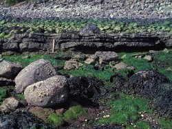
The outcrop at Cloghfin Port, although much faulted and possibly affected by landslipping, provides good exposures of Triassic to Cretaceous strata. | |
| Introduction: | |
The Cloghfin Port locality is situated on the east side of Island Magee, ~2.25km NE of Whitehead, Co. Antrim. Foreshore exposures provide a series of largely isolated outcrops through the Mesozoic strata ranging from the Triassic Mercia Mudstone Group to the Ulster White Limestone Formation, with the exception of the Waterloo Mudstone Formation. The Triassic Penarth Group has been described in detail by Ivimey-Cook (1975) and Griffith and Wilson (1982). The Cretaceous strata have been extensively described. Descriptions of the rocks and the contained fauna have been given by Tate (1865), Hull (1876), Hume (1897) and Hancock (1961). The Hibernian Greensands Formation has been studied by Reid (1971) who described the sponges, and the foraminifera were listed by Gough (1905). The lithostratigraphy of the Ulster White Limestone Formation was determined by Fletcher (1977). | |
| Description: | |
The Mercia Mudstone Group is only poorly exposed at Cloghfin Port and consists of reddish brown mudstones. About 2m of greenish grey mudstones representing the Collin Glen Formation occur beneath the Penarth Group. The Penarth Group sediments consist of the Westbury Formation and the Lilstock Formation:
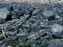 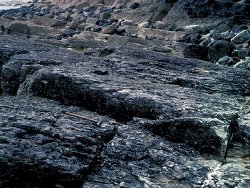 UPPER RHAETIAN - Lilstock Formation Silt, laminated, calcareous and silty mudstones with small slumps and very micaceous silty lenses, Protocardia rhaetica - seen 0.36m Mudstones, shaly and marls, grey, very silty, often laminated and included `pellets' of Lower Rhaetian shale; minor cross bedding and small slump structures - ~0.90m (Age not proven) Silt and marl, reddish brown, calcareous - 0.60m LOWER RHAETIAN - Westbury Formation Mudstones, shaly, dark grey, Rhaetavicula contorta and Protocardia rhaetica - 0.15m Mudstones, shaly, laminated, calcareous, with silt lenses, often massive, pale to medium grey - ~0.30m Mudstones, shaly, grey, calcareous - ~0.60m Mudstones, shaly, grey, with sandstone bands - ~0.60m Mudstones, shaly, micaceous, silty, thin silty seams with bone fragments - ~3.40m No Jurassic sediments are exposed at Cloghfin Port but there are extensive outcrops of most of the Cretaceous strata. In the Hibernian Greensands Formation (~10.5m thick), the Belfast Marls Member is represented by a thin sequence of dark green glauconitic marls with shell beds occurring as a 5m wide outcrop indifferently exposed at low tide. The occurrence of Acanthoceras and the belemnite Actinocamax primus indicates that the upper part of the member may be mid-Cenomanian age. The Island Magee Siltstones Member occurs as a 7m section exposed on foreshore reefs. It consists of hard and soft grey siltstones and marls which weather to a pale yellow colour. An extensive fauna includes the small corals Micrabacia cf. coronula and Stephanophyllia cf. bowerbankii together with Ratularia spp., Entolium cf. laminosum, Gryphaeostrea canaliculata, Inoceramus cf. hamiltonz, Neithea aequicostata, Neithea quinquecostata s.l., Pseudoptera sp., Epiaster sp. and Holaster cf. trecensis. There is no evidence of Turonian sediments at Cloghfin Port and the overlying Kilcoan Sands Member is 2.5m thick. 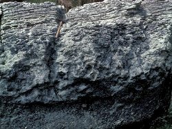 The Ulster White Limestone Formation is well exposed at Cloghfin Port and the sections are typical of those developed in the Larne-Lough Neagh Basin especially north and south of the Larne axis. The total thickness of the Ulster White Limestone Formation at about 34m is less than that developed in the Rathlin Basin but the pre-Larry Bane sequence is best developed here. All members from the Cloghfin Sponge Beds to the Glenarm Chalk Member are present in the Larne-Lough Neagh Basin. The Cloghfin Sponge Beds Member is restricted to the area between Woodburn and Glenarm. At Cloghfin Port this member is ~1.25m thick. This oldest chalk member is highly contaminated with glauconite and is characteristically rich in phosphatised pseudo- morphs of hexactinellid sponges. The basal bed (Bed A) takes on a distinctive cobbly appearance on weathering while Bed B consists of more evenly bedded and slightly less glauconitic chalk with a high proportion of orange-brown pseudomorphs which are especially common at the base. Bed C is also rich in sponges but is only sparsely glauconitic. This bed is overlain by a thin limestone containing pale yellow sponges in pebbles; this forms the base of the Galboly Chalk Member. Reid (1958) recognised two faunal divisions based on the common presence of species of Rhizopoterion: a lower division characterised by Rhizopoterion cf. tubiforme and an upper division with Rhizopoterion cribrosum in which the sponges are generally more complete and less strongly phosphatised. The boundary between these two faunal divisions appears to fall within Bed C. Glauconitised chalk pebbles demonstrate that the boundary with the Galboly Chalk Member is erosive. The latter is flintless and ~1.5m thick. From the Cloghastucan Chalk Member Gonioteuthis granulata and ornamented calyx plates of Marsupites can be collected from the thin unit between the green pebble sponge concentrate at the top of the Galboly Chalk and the Oweynamuck Flint Band, the plates being particularly common on the well marked bedding plane just below the flint band. The Creggan Chalk Member, 2.6m thick, is coarsely arenitic with a high content of comminuted Inoceramus shells. The distinctive gritty texture contrasts with the relatively smooth limestones of the containing members. All three beds of the Boheeshane Chalk Member, 10.7m thick, are well exposed here. The basal metre of Bed A is flintless but contains several horizons of glauconitised pebbles. The bed is characterised by Belemnitella ex gr. praecursor. Bed C contains five separate bands of large flints. The middle of the five bands, the Whitehead Flint Band, marks the highest known occurrence of Gonioteuthis and constitutes the local boundary between the Zones of Gonioteuthis quadrata and Belemnitella mucronata, corresponding to the boundary between the Lower and Upper Campanian. The Larry Bane Chalk, 5m thick, is completely exposed at Cloghfin Port. The division of the member into two beds is well developed with the characteristic fauna of Cretirhynchia woodwardi, Kingena pentangulata, Belemnitella mucronata senior, Echinocorys ex gr. conica and Echinocorys ex gr. marginata-subglobosa well represented. The Ballintoy Chalk Member is almost 11m thick and the Glenarm Chalk Member 3.3m thick before the succession is truncated by Palaeogene erosion. | |
| Importance: | |
The site is of national importance because of the range of Mesozoic strata preserved. With the exception of the Jurassic, all rocks between the Mercia Mudstone Group and the Glenarm Chalk Member are present. This provides one of the most complete sequences in the Larne-Lough Neagh Basin, demonstrating the facies and palaeogeographic variations between this and adjacent areas. The exposures of the Belfast Marls Member is probably the best collecting locality for this member as it is remarkably rich in small brachiopods and pectinids. | |
| Interpretation: | |
Several features of the Mesozoic sequence of the Larne-Lough Neagh Basin are well illustrated at Cloghfin Port. The division of the Penarth Group into the Westbury and Lilstock formations is clear. Within the Hibernian Greensands Formation the development of thick marls and greensands and the absence of Turonian strata in the area around the Larne axis can be demonstrated. The Cretaceous sediments represent a typical Larne-Lough Neagh Basin succession with the Cloghfin Sponge Beds overlain by all chalk members up to the Glenarm Chalk. This contrasts with the Ulster White Limestone in the adjacent areas; the Dalradian ridge and Rathlin Basin to the north, and the Lagan Valley to the south. | |
| Conclusions: | |
The Cloghfin Port section, although much faulted and probably subject to landslip, provides one of the best sequences in the Larne-Lough Neagh Basin, demonstrating facies and thickness changes in the Mesozoic. It provides opportunity for fossil collecting, especially in the Hibernian Greensands Formation. | |
| Notes: | |
For information on other Triassic sites see; Key Site 1197 - Brown's Bay, Island Magee Key Site 1199 - Collin Glen Key Site 1200 - Scrabo Hill - Triassic Key Site 1201 - Milltown Key Site 1202 - Drapersfield Quarry Key Site 1203 - Lissan Water Key Site 1204 - Curraghlane. For general information on the Triassic System in N. Ireland see; Key Site 1192 - The Triassic System in N. Ireland - Introduction. | |
| Keywords | |
|---|---|
| Rocks: | Greensand, Limestone, Marl, Mudstone, Sand, Siltstone |
| Fossil Groups: | Belemnite, Brachiopod, Coral, Sponge |
| Fossil List: | Actinocamax primus |
| Relations: | Marine sediments |
| Access | |
|---|---|
| Approach: | ~2.25km NE of Whitehead. Access is by a path from a minor road. |
| Management: | |
These foreshore exposures, situated at the base of a steep cliff, could only be at risk from coastal development, but this would seem unlikely. Collecting of fossils from the Belfast Marls would not be a major problem as these sediments are subject to normal coastal erosion. | |
| Threats: | Coastal development |
| References (10) | |||
|---|---|---|---|
| Fletcher, T.P., 1977. Lithostratigraphy of the Chalk (Ulster White Limestone Formation) in Northern Ireland. Report of the Institute of Geological Sciences, vol. 77/14. | |||
| Gough, G.C., 1905. Foraminifera of the greensand at Whitehead. Irish Naturalists Journal, vol. 14, pp.109. | |||
| Griffith, A.E. & Wilson, H.E., 1982. Geology of the country around Carrickfergus and Bangor. Memoir of the Geological Survey of Northern Ireland, Sheet 29 (N. Ireland). | |||
| Hancock, J.M., 1961. The Cretaceous System in Northern Ireland. Quarterly Journal of the Geological Society of London, vol. 117, pp.11-36. | |||
| Hull, E., 1876. The country around Antrim, Larne and Carrickfergus. Memoirs of the Geological Survey of Ireland. | |||
| Hume, W.F., 1897. The Cretaceous strata of County Antrim. Quarterly Journal of the Geological Society of London, vol. 53, pp.540-606. | |||
| Ivimey-Cook, H.C., 1975. The stratigraphy of the Rhaetic and Lower Jurassic in East Antrim. Bulletins of the Geological Survey of Great Britain, numb. 50, pp.51-70. | |||
| Reid, R.E.H., 1958. Remarks on the Upper Cretaceous Hexactinellida of County Antrim. Irish Naturalists Journal, vol. 12, pp.236-243. | |||
| Reid, R.E.H., 1971. The Cretaceous rocks of north-eastern Ireland. Irish Naturalists Journal, vol. 1, pp.105-129. | |||
| Tate, R., 1865. On the correlations of the Cretaceous formations of the NE of Ireland. Quarterly Journal of the Geological Society of London, vol. 21, pp.15-44. | |||
| Record type: | ESCR report | ||
| Entered by: | E M Porter | ||
| Last updated: | 6 Jun 2005 | ||
| Enlander, I., Dempster, M. & Doughty, P., 2026. Cloghfin Port, Island Magee, County Antrim, site details. [In] Earth Science Conservation Review. https://www.habitas.org.uk/escr/site.php?item=1198. Accessed on 2026-11-06. |
| Previous Site | Next Site |