
| Previous Site | Next Site |
Earth Science Conservation Review
| Coalisland Brick Pit | Tyrone |
| Site number: | 282 | File Number: | H86 |
| ESCC: | EA | ||
| Locality Type: | Pit | Status: | ESCR |
| Grid Reference: | H8366 1 km square | ||
| Google maps: | 54.536,-6.71775 | ||
| County: | Tyrone | Council area: | Mid Ulster District Council |
| Period: | Carboniferous | ||
| Stages: | Westphalian | ||
| Lithostrat: | Coal Measures, Subcrenatum Marine Band | ||
| Site Description | |
|---|---|
 | |
| Highlights: | |
The exposures in Coalisland Brick Pit are the only known examples of 'Coal Measures' strata of Westphalian age that occur at surface in Northern Ireland. | |
| Description: | |
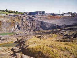
Old excavations at Coalisland, in search of brick clays, cover a vast area and have resulted in a devastated landscape of tipped material, active and abandoned workings on the south-west side of the town. The precise stratigraphical position of the beds exposed in the most recent workings is not clear. They are representative however of the 'Coal Measures' strata and do contain coal seams. The Coalisland Brick Pit is located on the southwestern outskirts of Coalisland on the west side of the A45 road to Dungannon. The new excavations occur in the NE corner of the pit and expose some 10m of strata that are inclined at ~15 deg. to the NW. At the top of the face is a thin coal seam which may equate with the Seat Coal (0.25m thick) as defined by Fowler and Robbie (1961, p.61). The strata lying below the coal are exposed therefore in this new pit and in the north face of the recently abandoned, and now partly flooded, former pit. These consist of poorly bedded unfossiliferous grey mudstones with thin beds of very fine-grained sandstone. Slight weathering and degrading of this face results in the loss of obvious bedding features which is thus only defined by these thin beds of sandstone. Colour laminations in the mudstones in the new pit are much more obvious. | |
| Interpretation: | |
The absence of primary red-beds and indeed of any red, brown or purple colouration is characteristic of the Coal Measures strata at Coalisland. The sediments were deposited on an alluvial plain in lakes with occasional thin sandstones representing an input from rivers. The bedded nature of the mudstones indicates that emergence did not occur and that deposition was generally a continuous process uninterrupted by formation of palaeosols (fossil soils). The accumulation of vegetable remains resulted in the formation of thick peat deposits that formed the coal seams for which this area has been famous since the 17th century. Evidence for marine incursions onto the alluvial plain is found in the presence of fossiliferous bands containing brachiopods and goniatites, such as occur in the Subcrenatum Marine Band. | |
| Conclusions: | |
The Coalisland Brick Pit is probably the best exposure of Coal Measures strata in Subarea-7 and in Northern Ireland. | |
| Notes: | |
For information on other sites in Subarea-7 see Key Site 1180 - Subarea-7; Dungannon-Coalisland-Cookstown. | |
| Keywords | |
|---|---|
| Rocks: | Coal, Mudstone, Sand, Sandstone |
| Fossil Groups: | Brachiopod, Goniatite |
| Relations: | Fluvial sediments, Lacustrine sediments |
| Paleoenv: | alluvial plain |
| Access | |
|---|---|
| Approach: | The Coalisland Brick Pit is located on the southwestern outskirts of Coalisland on the west side of the A45 road to Dungannon. |
| References (1) | |||
|---|---|---|---|
| Fowler, A. & Robbie, J.A., 1961. Geology of the country around Dungannon. Memoirs of the Geological Survey Northern Ireland, HMSO, Belfast. | |||
| Record type: | ESCR report | ||
| Entered by: | Doughty, P.J. | ||
| Enlander, I., Dempster, M. & Doughty, P., 2026. Coalisland Brick Pit, County Tyrone, site details. [In] Earth Science Conservation Review. https://www.habitas.org.uk/escr/site.php?item=282. Accessed on 2026-11-06. |
| Previous Site | Next Site |