
| Previous Site | Next Site |
Earth Science Conservation Review
| Drapersfield Quarry | Londonderry |
| Site number: | 1202 | ||
| ESCC: | ED | ||
| Locality Type: | Quarry (disused) | Status: | local interest |
| Grid Reference: | H841768 Centroid | ||
| Google maps: | 54.63281,-6.69767 | ||
| County: | Londonderry | Council area: | Mid Ulster District Council |
| Period: | Triassic | ||
| Stages: | Scythian | ||
| Lithostrat: | Ballyloughan Formation, Sherwood Sandstone Group | ||
| Site Description | |
|---|---|
 | |
| Highlights: | |
The exposure at Drapersfield Quarry, County Londonderry is one of the few exposures of the Ballyloughan Formation. | |
| Introduction: | |
The site lies just north of the Ballinderry River and is 3.75km SE of Cookstown. The quarry face is the best exposure of the Ballyloughan Formation. Shown on the original survey map (GSI, 1880) as Upper Red and Mottled Sandstone (Bunter) of Triassic age, the area was resurveyed (GSNI, 1983) and a Triassic age confirmed. The strato- type for the Ballyloughan Formation is the Ballyloughan Bridge borehole. | |
| Description: | |
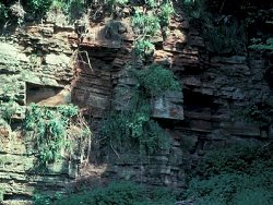
In the north bank of the Ballinderry River (H842 768) about 300m WSW of Drapersfield House, there is an exposure of red sandstone and mudstone in thin beds up to 20cm thick. Coarse-grained red sandstone with clay galls passes upwards into medium-grained sandstone with thin partings of dark red micaceous mudstone. In the disused quarry about 100m SW of Drapersfield House, ~9m of red sandstone and mudstone are preserved. The sandstone occurs in units up to 1m thick though usually less than 30cm thick. The sandstone is for the most part medium or fine- grained and is usually slightly muddy. The bedding is regular with small-scale cross-bedding. 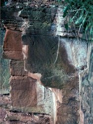 | |
| Importance: | |
This is the best known exposure of the Ballyloughan Formation. As such it provides clear evidence for the depositional environment of the Sherwood Sandstone Group; a group that is also important for hydrogeological and hydrocarbon exploration. It is of local importance and should be conserved. | |
| Interpretation: | |
The section at Drapersfield Quarry provides evidence for depositional environments of the Sherwood Sandstone Group. The small-scale cross-bedded units provide evidence of fluviatile conditions possibly as in-channel bars. The rhythmic nature of the sequence in general can be explained with the siltstones and fine sandstones deposited by sheetfloods and the thin mudstones representing late stage deposition from standing bodies of water. | |
| Conclusions: | |
The Drapersfield Quarry site provides evidence for the origins of the Triassic sandstones in Co. Londonderry. Because of its added importance for reservoir studies, this site should be preserved. | |
| Notes: | |
For information on other Triassic sites see Key Site 1197 - Brown's Bay, Island Magee Key Site 1198 - Cloghfin Port, Island Magee Key Site 1199 - Collin Glen Key Site 1200 - Scrabo Hill - Triassic Key Site 1201 - Milltown Key Site 1203 - Lissan Water Key Site 1204 - Curraghlane. For general information on the Triassic System in N. Ireland see Key Site 1192 - The Triassic System in N. Ireland - Introduction. | |
| Keywords | |
|---|---|
| Rocks: | Sand, Sandstone |
| Structures: | cross-bedding, ripple marks |
| Relations: | Aeolian sediment, Fluvial sediments |
| Paleoenv: | desert |
| Measurements | |||||
|---|---|---|---|---|---|
| Length: | Width: | Height: | 9 m | ||
| Depth: | Area: | ||||
| Access | |
|---|---|
| Approach: | 3.75km SE of Cookstown. Access to the site is along a path from the factory just south of the Drapersfield Road. |
| Management: | |
The site is at most risk from landfill, although its small size would probably preclude this. | |
| Map(s): | GSNI (1983) 1:50,000 Geological Sheet 27 (Cookstown) GSI (1880) One inch:One mile Geological Sheet 27 (Cookstown). | ||
| Record type: | ESCR report | ||
| Entered by: | E M Porter | ||
| Last updated: | 8 Jan 2005 | ||
| Enlander, I., Dempster, M. & Doughty, P., 2026. Drapersfield Quarry, County Londonderry, site details. [In] Earth Science Conservation Review. https://www.habitas.org.uk/escr/site.php?item=1202. Accessed on 2026-11-06. |
| Previous Site | Next Site |