
| Previous Site | Next Site |
Earth Science Conservation Review
| Dromore - Devonian | Tyrone |
| Site number: | 317 | File Number: | H36 |
| ESCC: | EO | ||
| Locality Type: | Cliff | Status: | ASSI |
| Grid Reference: | H349627 Centroid | ||
| Google maps: | 54.51195,-7.46115 | ||
| County: | Tyrone | Council area: | Fermanagh & Omagh District Council |
| Period: | Devonian | ||
| Stages: | Famennian, Frasnian | ||
| Lithostrat: | Fintona Group, Shanmullagh Formation (Form Blm) | ||
| Site Description | |
|---|---|
 | |
| Description: | |
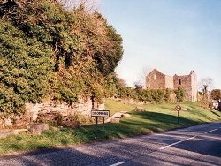
About 8m of Devonian red-beds are exposed in the cliff line that borders the north side of the Irvinestown Road at Dromore, Co. Tyrone. They consist primarily of sandstones interbedded with thin mudstones and siltstones. Sandstones occur in beds ranging from 5-33m thick, and are parallel bedded; thin beds consist of hard, grey-purple, calcareous fine-grained and silty sandstone with parallel laminations whilst thick beds show a very fine grading upwards and contain thin rip-up clasts of purple-red mudstone.
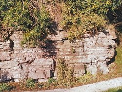 Shallow broad channels and lenticular bedforms are occasionally found in the sandstones. An example occurs at the west end of this cliff line in a 0.23m thick fine-grained sandstone with a total width of 10m. Steep-sided channelised sandstones are uncommon in the Shanmullagh Formation although they do occur at a few localities. Perhaps the most remarkable example of a deeply incised, highly irregular, multi-fill channel complex was formerly exposed at the eastern end of the cliff directly below the ruined church. This sort of feature is not known from any other exposure but this may be a reflection of the poor quality of most other exposures. Unfortunately much of this channel complex is now concealed by the construction of the new concrete walkway. | |
| Notes: | |
For general information and reference list on the Shanmullagh Formation with respect to stratotype see Key Site 1150 - Shanmullagh Formation; Stratotype localities. For general information and reference list on the Shanmullagh Formation with respect to miospore localities see Key Site 1151 - Shanmullagh Formation; Miospore localities. For general information and reference list on the Devonian System in N. Ireland see Key Site 1147 - The Devonian System in N. Ireland - Introduction. | |
| Keywords | |
|---|---|
| Rocks: | Mudstone, Sand, Sandstone, Siltstone |
| Access | |
|---|---|
| Approach: | Beneath and west of ruined church on the southwest side of Dromore. |
| Map(s): | GSNI (1982a) 1:50,000 Sheet 45 (Enniskillen); GSNI (1982b) 1:50,000 Sheet 46 (Clogher); O.S. 1:50,000 Sheet 18 (Enniskillen). | ||
| Record type: | Environment Serv. GIS, ESCR report | ||
| Entered by: | Doughty, P.J. | ||
| Enlander, I., Dempster, M. & Doughty, P., 2026. Dromore - Devonian, County Tyrone, site details. [In] Earth Science Conservation Review. https://www.habitas.org.uk/escr/site.php?item=317. Accessed on 2026-11-06. |
| Previous Site | Next Site |