
| Previous Site | Next Site |
Earth Science Conservation Review
| Capecastle Quarry | Antrim |
| Site number: | 1211 | ||
| ESCC: | ED | ||
| Locality Type: | Quarry (disused) | Status: | ASSI |
| Grid Reference: | D101364 Centroid | ||
| Google maps: | 55.16294,-6.27246 | ||
| County: | Antrim | Council area: | Causeway Coast & Glens Borough Council |
| Period: | Cretaceous | ||
| Stages: | Campanian | ||
| Lithostrat: | Ballintoy Chalk Member, Boheeshane Chalk Member, Creggan Chalk Member, Glenarm Chalk Member, Larry Bane Chalk Member, Ulster White Limestone Formation | ||
| Site Description | |
|---|---|
 | |
| Highlights: | |
The site contains excellent exposures of the Ulster White Limestone Formation. In particular the influence of the positive Dalradian ridge during chalk sedimentation can be demonstrated. | |
| Introduction: | |
The Mesozoic rocks at Capecastle Quarry outcrop on the western side of Knocklayd, Co. Antrim, 5km NE of Armoy. Knocklayd was mentioned by Bryce (1837) in his study of NE Antrim and the area was mapped and an explanatory memoir produced by Symes et al. (1888). More recent studies were by Hancock (1961), Wilson and Robbie (1966) and Fletcher (1977). | |
| Description: | |
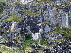
At Capecastle the quarry floor is in glauconitic Creggan Chalk Member which is capped by a stromatolitic biostrome. The prominent bedding planes of the Larry Bane Chalk Member can be seen near the base of the face. The intervening Boheeshane Chalk Member is only ~3m thick compared with a maximum thickness of 24.19m in the type section in Boheeshane Bay in the Rathlin Basin. The overlying 20m of chalk comprises the Ballintoy Chalk and Glenarm Chalk Members. The fauna obtained from the quarry by Wilson and Robbie (1966) was: Porosphaera globularis, Echinocorys scutata, Carneithyris sp., Cretirhynchia sp., Orbirhynchia sp., Inoceramus sp., Ostrea sp., Belemnitella langei, and Belemnitella mucronata minor. | |
| Importance: | |
This is the best exposure of the Ulster White Limestone on the Dalradian ridge. It enables the influence of this more positive area during deposition of the Ulster White Limestone to be demonstrated. It is therefore of national importance and should be conserved. | |
| Interpretation: | |
No Santonian chalk is found in the Capecastle Quarry area where the basal Campanian Creggan Chalk Member overlies the Sherwood Sandstone Group. It is itself overlain disconformably by the Boheeshane Group Member. Sedimentation continued through the Larry Bane Chalk, Ballintoy Chalk and Glenarm Chalk members with the younger members of the Ulster White Limestone Formation removed by pre-basalt erosion. These relationships reflect the importance of the Dalradian ridge as a more positive feature during chalk sedimentation. The sequence is much thinner and less complete than those in the flanking Rathlin Basin and Larne-Lough Neagh Basin. | |
| Conclusions: | |
At Capecastle Quarry, the Campanian chalk sequence between the Creggan Chalk Member and the Glenarm Chalk Member is exposed. The history of chalk sedimentation over the Dalradian ridge can be determined at this site which should be conserved. | |
| Notes: | |
For general information on the Cretaceous System in N. Ireland see Key Site 1194 - The Cretaceous System in N. Ireland - Introduction. For information on other Cretaceous sites see Key Site 1207 - White Rocks - Cretaceous, Key Site 1208 - White Park Bay, Key Site 1209 - Dunnaglea-Larry Bane Bay, Key Site 1210 - Port Calliagh-Ballycastle, Key Site 1212 - Garron Point-Cloghastucan, Key Site 1213 - Glenarm Quarry, Key Site 1214 - Creggan Quarry, Key Site 1215 - Portmuck, Island Magee, Key Site 1216 - White Head, Key Site 1217 - Clarehill Quarry, and Key Site 1218 - Kilcoan, Island Magee. | |
| Keywords | |
|---|---|
| Rocks: | Limestone |
| Fossil Groups: | Belemnite, Echinoderm |
| Fossil List: | Belemnitella langei , Belemnitella mucronata minor , Carneithyris sp., Echinocorys sp. , Inoceramus sp. |
| Relations: | Marine sediments |
| Measurements | |||||
|---|---|---|---|---|---|
| Length: | Width: | Height: | 23 m+ | ||
| Depth: | Area: | ||||
| Access | |
|---|---|
| Approach: | 5km NE of Armoy. Access to the site is via a minor road that runs down Glentaisie from Ballycastle to Armoy. |
| Threats: | Landfill or afforestation |
| References (5) | |||
|---|---|---|---|
| Bryce, J., 1837. On the Geological structure of the north-eastern part of the County of Antrim. Transactions of the Geological Society of London, vol. 5, pp.69-81. | |||
| Fletcher, T.P., 1977. Lithostratigraphy of the Chalk (Ulster White Limestone Formation) in Northern Ireland. Report of the Institute of Geological Sciences, vol. 77/14. | |||
| Hancock, J.M., 1961. The Cretaceous System in Northern Ireland. Quarterly Journal of the Geological Society of London, vol. 117, pp.11-36. | |||
| Symes, R.G., Egan, F.W. & McHenry, A., 1888. Explanatory Memoir to accompany Sheets 7 and 8. Memoirs of the Geological Survey of Ireland. | |||
| Wilson, H.E. & Robbie, J.A., 1966. Geology of the country around Ballycastle. Memoirs of the Geological Survey Northern Ireland. | |||
| Record type: | ESCR report | ||
| Entered by: | E M Porter | ||
| Last updated: | 8 Jan 2005 | ||
| Enlander, I., Dempster, M. & Doughty, P., 2026. Capecastle Quarry, County Antrim, site details. [In] Earth Science Conservation Review. https://www.habitas.org.uk/escr/site.php?item=1211. Accessed on 2026-11-05. |
| Previous Site | Next Site |