
| Previous Site | Next Site |
Earth Science Conservation Review
| Cappagh Quarry | Tyrone |
| Site number: | 320 | File Number: | H66 |
| Locality Type: | Quarry (working) | Status: | ASSI |
| Grid Reference: | H697674 Centroid | ||
| Google maps: | 54.55058,-6.92284 | ||
| County: | Tyrone | Council area: | Mid Ulster District Council |
| Period: | Devonian | ||
| Stages: | Middle Devonian, Upper Devonian | ||
| Lithostrat: | Barrack Hill Andesite Member, Fintona Group, Gortfinbar Conglomerate Formation, Greenhill Andesite Member | ||
| Site Description | |
|---|---|
 | |
| Highlights: | |
Contemporaneous lavas occur within the Gortfinbar Conglomerate Formation at two levels of which the thickest and areally most extensive is located at the base of the formation and belongs to the Barrack Hill Member. K-Ar wholerock dating of the lavas gives a wide spread of ages with a minimum of 375+/-2Ma suggesting that extrusion occurred at about the Middle - Upper Devonian boundary. | |
| Introduction: | |
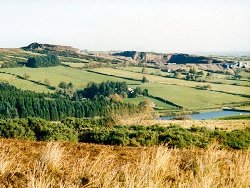
The outcrop of the Fintona Group south of the Tempo-Sixmilecross Fault comprises about 3500m of unfossiliferous red-beds. The Barrack Hill Member consists of flow-banded lavas and occurs at the base of the Gortfinbar Conglomerate Formation, the middle of 3 formations recognised in that area. The outcrop of the lavas is confined to the eastern end of this Devonian outcrop around the village of Cappagh, Co. Tyrone. Location: The best exposure of lavas of the Barrack Hill Member is found in the large working quarry located some 700m north of Cappagh. However because of the relative hardness of the lavas compared to the associated sedimentary rocks, many smaller quarries were also opened in this area and numerous outcrops are found on higher ground around Barrack Hill. Bibliographic Review: The existence of lavas in the Cappagh area of Co. Tyrone was discovered by the Geological Survey of Ireland in 1875. The similarity of the enclosing red sandstones and conglomerates with those in the, "... middle of Scotland....", was noted by those geologists and both the lavas and sedimentary rocks were assigned to the Old Red Sandstone. Most remarkable was their appreciation of the origin of the lavas as volcanic eruptions contemporaneous with, and whose erosion provided the boulders for, the conglomerates of the Gortfinbar Formation. The 1:50,000 geological map of the Pomeroy area (Sheet 34, GSNI, 1979) formalised the lithostratigraphical nomenclature of these rocks and defined their distribution more accurately. General Geology: The thickness of the Gortfinbar Conglomerate Formation of the Fintona Group is estimated at between 2400m and 2700m. The two members consisting of lavas are located in the lowest 800m of the formation. At the base of the formation the Barrack Hill Member is 260m thick and the succeeding Greenhill Member is of unknown thickness but forms a small outcrop some 10km southwest of Cappagh. In view of the tremendous disparity between the great thickness of conglomerates and the position of the relatively thin lavas at and just above the base of the formation, there must be some doubt as to the true thickness of the Gortfinbar Formation in view of the fact that the volcanic debris only came from the lavas and accumulated on their flanks. It is also possible that volcanic debris was derived from lava piles that have been eroded since Devonian times. To date neither the upper nor lower contacts of the Barrack Hill or Greenhill members have been seen in outcrop and thus their true relationship to the contemporaneous sediments cannot be evaluated. It is still believed by many geologists that the internal banding in the volcanic rock is indicative of an origin as lavas flows, the banding supposedly illustrating the presence of magmatic rolls induced by flow. Radiometric analysis (Rundle, 1988) of the lavas by the K-Ar whole-rock method gives a spread of dates as follows: 377+/-10, 372+/-10, 272+/-7, 284+/-7, 266+/-7, and 376+/-10 Ma. Taken in conjunction with 3 dates determined from radiometric analysis in 1978 (Rundle) which were 274+/-9, 282+/-10 and 376+/-12 Ma, the results fall into two well defined and distinct groups; one at 375+/-2 Ma and the other at 275+/-6 Ma. The older group of ages is very well defined and comes from relatively fresh purple-grey lava and as such may well record a good age for their extrusion at about the boundary of the Givetian - Frasnian Stages, which corresponds to the junction between the Middle and Upper Devonian. The younger group of ages, which was obtained from lava samples that possess a distinctly red colour suggesting a degree of alteration, is less well defined yet still quite distinct and points to an event sometime in the middle Permian, at about 275 Ma. It is suggested that this age is due to a later resetting event which only affected the parts of the outcrop of the Barrack Hill Member which provided the red-coloured samples of lava. Petrographic analysis of the lavas shows them to be trachy- andesites or trachytes in which the original ferro-magnesian minerals are frequently altered to hematite and groundmass plagioclase is kaolinised or chloritised. Feldspar laths in the fine groundmass sometimes show a trachytic arrangement, as might be expected in a flow-banded lava, although some samples show a pilotaxitic groundmass (no preferred orientation). Vesicular lavas are common and the vesicles may be infilled by a variety of minerals including calcite, chlorite, granular quartz and iron oxide. | |
| Description: | |
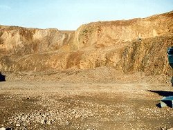
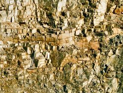
Cappagh Quarry is an extensive outcrop of lavas of the Barrack Hill Member of the Gortfinbar Conglomerate Formation. No contacts with contemporaneous sedimentary rocks are yet exposed there. Throughout the quarry are vertical zones, of varying thickness, in which the original purple-grey colour of the 'fresh' lava is changed to shades of yellow, pink, green and red.
  | |
| Interpretation: | |
Neither the upper nor lower contacts of the lavas of the Barrack Hill Member are exposed and their origin, as subaerial flows forming a topographically elevated volcanic centre, is still not proven satisfactorily. Despite the marked variation in the radiometric dates obtained from samples out of Cappagh Quarry there is a convincing group of dates that suggest a timing of extrusion coinciding with the boundary between the Middle and Upper Devonian some 375 million years ago. Prolonged and rapid erosion of the lavas led to the incorporation of huge amounts of volcanic debris in sedimentary rocks, in particular on alluvial fans, that built up around the centre(s) and most likely, in time, engulfed the source of this detritus. | |
| Conclusions: | |
Volcanic rocks of Middle - Upper Devonian age are uncommon in Ireland and in Northern Ireland these are the only Devonian lavas whose age is known accurately. In northeast Antrim, the 'dacitic' Cushendall Porphyry is compositionally very close to the lavas of the Barrack Hill Member but has not been dated, and even its Devonian age is unproven. | |
| Notes: | |
For general information and reference list on the Shanmaghery Sandstone, Gortfinbar Conglomerate and Raveagh Sandstone Formations see Key Site 1152 - Fintona Block south of Tempo-Sixmilecross Fault. For general information and reference list on the Devonian System in N. Ireland see Key Site 1147 - The Devonian System in N. Ireland - Introduction. | |
| Keywords | |
|---|---|
| Minerals: | Calcite, Chlorite |
| Rocks: | Andesite, Conglomerate, Sand, Sandstone, Trachyte |
| Structures: | flow unit, flow-banding, magmatic roll, vesicles |
| Relations: | Extrusion |
| Access | |
|---|---|
| Approach: | 700m north-north-east of Cappagh village, Co.Tyrone. |
| References (1) | |||
|---|---|---|---|
| Rundle, C.C., 1988. Potassium-Argon ages for andesitic lavas from the Cappagh Quarry, Co. Tyrone, Northern Ireland. Natural Environment Research Council Scientific Services Isotope Geology Centre, Radiogenic Isotopes Section Internal Report RI/88/2 (Unpublished Report). | |||
| Map(s): | GSNI (1979) 1:50,000 Sheet 34 (Pomeroy); O.S. 1:50,000 Sheet 19 (Armagh). | ||
| Record type: | Environment Serv. GIS, ESCR report | ||
| Entered by: | Doughty, P.J. | ||
| Enlander, I., Dempster, M. & Doughty, P., 2026. Cappagh Quarry, County Tyrone, site details. [In] Earth Science Conservation Review. https://www.habitas.org.uk/escr/site.php?item=320. Accessed on 2026-11-05. |
| Previous Site | Next Site |