
| Previous Site | Next Site |
Earth Science Conservation Review
| Oughtmore Mountain - PreCambrian | Tyrone |
| Site number: | 128 | ||
| ESCC: | EO | ||
| Locality Type: | Inland exposure | Status: | ESCR |
| Grid Reference: | H725837 Centroid | ||
| Google maps: | 54.69658,-6.87554 | ||
| County: | Tyrone | Council area: | Mid Ulster District Council |
| Period: | Precambrian | ||
| Stages: | Moinian | ||
| Lithostrat: | Central Tyrone Inlier, Corvanaghan Formation | ||
| Site Description | |
|---|---|
 | |
| Highlights: | |
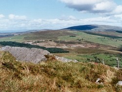
The site consists of a number of weathered slab outcrops of the Corvanaghan Formation allowing study of lithological variation within the Formation as well as structural features including beddingcleavage relationships and folding. | |
| Introduction: | |
Oughtmore Mountain is situated on open moorland directly south of Davagh Forest, about 8km north-west of Cookstown. It is located close to the north-eastern end of the Central Tyrone Inlier. This pre-Dalradian (Moinian?) inlier has faulted contacts with gabbro and diorite of the Tyrone Igneous Complex (Ordovician). Access to the site is via fenced rough pastureland from Slaght Road or from the path which skirts Beleevnamore Mountain at the southern edge of Davagh Forest. Portlock (1843) mapped the lenticular form of the Central Inlier, and distinguished its rocks from the "Metamorphic Rocks (hornblendic type)" which surround it (Tyrone Volcanic Group and Tyrone Plutonic Complex (Geological Survey of Northern Ireland, 1995). However, Portlock failed to differentiate between the "Mica Schists" of the Inlier and the rocks which form the southern Sperrin Mountains Dalradian. On the first edition of the one inch to one mile scale geological maps (Sheets 26 and 34, Geological Survey of Ireland, 1877, 1882) rocks in the area of the Central Tyrone Inlier were described as "Schists and Gneisses". Although this early map distinguished between the metasedimentary rocks of the Inlier and the surrounding "Pyroxene Rocks" (Tyrone Plutonic Complex), both were nevertheless categorised "Probably of Pre-Cambrian or Upper Laurentian age". The Geological Memoir which accompanied Sheet 26 (Nolan, 1884) outlined key differences between "schist and gneiss" in the central portion of the Tyrone Inlier and chloritic schists elsewhere on the map (Tyrone Volcanic Group and Dalradian). It also described, in some detail, the lithologies of the Central Inlier and what was thought to be a gradational boundary between the quartzose schist and gneiss at the core of the Inlier and the hornblendic rocks (Tyrone Plutonic Complex) surrounding it. Cole (1900) presented a more detailed description of the petrology of what he referred to as the "Central Axis" in Tyrone and suggested that "the gneissic core of eastern Tyrone appears to owe its characters to the intimate intrusion of ancient aplitic granite magma into pre-existing and fairly basic schists". Cole's interpretation differed from Nolan's and Portlock's in one key respect. He observed that the gabbros and the granite of Slieve Gallion were emplaced successively either side of, but did not seem to have penetrated, a pre-existing gneissic mass. Hartley (1933) considered the Central Tyrone Inlier to be of Dalradian age. He produced a detailed map and described the dominant lithologies as "granulitic quartz-feldspar biotite schists and muscovite-biotite gneisses". Hartley believed that these rocks most likely originated as, "a recrystallised ... and highly folded series of banded arenaceous and argillaceous sediments". Hartley viewed the Central Inlier simply as a repetition of the "Sperrin Schists" and claimed that the higher (sillimanite) metamorphic grade of the Inlier was a result of impregnation of the Central Inlier by granitic veins. During the 1960's, the Geological Survey of Northern Ireland mapped the SW end of the Tyrone Inlier. On the second edition of the Pomeroy map (Sheet 34, Geological Survey of Northern Ireland, 1979) a clear distinction was made between "siliceous granulite and quartzo-feldspathic gneiss" of the Central Inlier (referred to for the first time as the Corvanaghan Formation), and the surrounding Tyrone Basic Plutonic Complex. Both groups of rock were however still ascribed a Dalradian age and it was observed that the Central Inlier was unconformably overlain by the Ordovician volcanic rocks of the Tyrone Volcanic Group (Cobbing et al., 1965, Geological Survey of Northern Ireland, 1979). The second edition of Geological Sheet 26 (Draperstown, Geological Survey of Northern Ireland, 1995) includes most of the outcrop of the Central Inlier (Corvanaghan Formation) which is shown as being of "Moinian?" age. The most recent data available (Hutton, (pers. comm.), Earls et al., 1996) indicates that the age of the Tyrone Central Inlier is in the region of 650Ma based on Rb-Sr dates for muscovite and feldspars in two pegmatites which cross-cut the Inlier. Furthermore, Hutton has also pointed to the presence of significant hornblende, biotite, chlorite (green bed?) assemblages which may indicate an affinity with the Grenville Terranes of Northern America rather than with other Northern British Moinian Terranes. | |
| Description: | |
The Oughtmore Mountain site consists of a number of weathered crags consisting mainly of medium to coarse-grained grey and pinkish-grey psammite and quartz-biotite schist. In parts, the coarser lithologies have a gneissic texture with pink K-feldspar and grey quartz banding and segregation. Lithological banding (probably in part representing original sedimentary bedding) is also visible particularly where quartz-biotite schists are interbedded with more massive psammites. Occasionally, where coarse gritty psammite is interbedded with finer-grained lithologies, graded-bedding and hence way-up of the strata is discernible (dip and younging towards the north). Throughout the site there is evidence of metamorphic segregation. This is most commonly manifested as early-formed, foliation parallel, quartz "sweats" and as quartz-K-feldspar-muscovite pegmatite veins. On the summit of Oughtmore, and directly to the SE of the fence which runs NE-SW along the eastern slopes of Oughtmore, there are numerous weathered outcrops of well-bedded units (up to 0.5m thick) comprising quartz-biotite psammite and quartz schist. In this area, the dominant foliation dips at 10° NE. There are many good examples of small-scale, tight complimentary fold-pairs with north-north-east - south-south-east trending axial traces. Directly south of Oughtmore summit, a zone of tight intrafolial folding of early formed quartz segregation veins, illustrates the complex and polyphase nature of the deformation 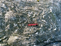 Throughout the site, a consistently orientated stretching lineation (plunging at 10° NW) is defined by quartz rods on the main foliation surfaces. | |
| Importance: | |
Oughtmore is a site of national importance offering access to strata representative of the Corvanaghan Formation. The site contains a wide variety of lithologies and structures on weathered and etched surfaces which allow detailed examination of structures. | |
| Interpretation: | |
The rocks at this site form part of the Central Tyrone Inlier, a fragment of pre-Dalradian Proterozoic crust which now forms part of the Tyrone-Girvan Sub-Terrane of the Midland Valley Terrane (Bluck et al., 1992). Doubts still surround the exact status and origin of these rocks and the fact that the Central Inlier is in sheared and faulted contact with the surrounding rocks (Tyrone Intrusive Complex) only serves to obscure the status of the Inlier. The predominance of quartz and alkali feldspar rich psammites and schists points to a predominantly siliciclastic sedimentary protolith. However, recently, Hutton (pers. comm.) has suggested that the inlier may be in fact be more mafic in nature and has pointed to certain lithological similarities with Grenvillian "greenstone" belts in North America. Hutton has also raised the possibility that the Central Inlier may be part of a Gondwanaland Type Assemblage and therefore have shared affinities with basement in the south of Britain. During pre-Caledonian times, the rocks of the Central Inlier underwent intense deformation resulting in at least 3 identifiable phases of folding. This deformation was accompanied by high grade metamorphism (sillimanite grade). The Central Tyrone Inlier could conceivably represent in-situ autochthonous metamorphic basement to the Midland Valley Terrane. Alternatively and probably more likely, it may be an allochthonous terrane, a slice of basement formed elsewhere and transposed to its present position by major sinistral strike slip or transpressional faulting (Hutton, 1987). | |
| Conclusions: | |
This site is of national importance offering an opportunity to study a wide range of lithologies and structures representative of the Corvanaghan Formation. The Central Tyrone Inlier, in which this site is located, remains one of the least understood and most enigmatic component terranes of the Precambrian basement of Northern Ireland and will no doubt be the subject of future scientific studies. | |
| Notes: | |
For information and references on other sites within the Pre-Dalradian Central Tyrone Inlier see the following site: Key Site 129 - Eagles Rocks For information and references on sites within the Pre-Dalradian Lough Derg Inlier see the following sites: Key Site 125 - Croagh Mountain Key Site 126 - Gadalough Key Site 127 - Larkhill For general information on the Pre-Dalradian rocks of Northern Ireland see the following site: Key Site 123 - The Pre-Dalradian Rocks of Northern Ireland For information on the Dalradian rocks of Northern Ireland see the following site: Key Site 124 - The Dalradian Rocks of Northern Ireland For general information and an extensive reference list on the Precambrian of Northern Ireland see the following site: Key Site 122 - An Introduction to the Precambrian of Northern Ireland This site is also important for Structural Geology. See Key Site 643 - Oughtmore Mountain. | |
| Keywords | |
|---|---|
| Rocks: | Psammite, Schist |
| Access | |
|---|---|
| Approach: | Oughtmore Mountain is situated on open moorland directly south of Davagh Forest, about 8km north-west of Cookstown. |
| Management: | |
The site is located within 1km of the south-eastern limit of Davagh Forest, in a remote and exposed area of partially fenced moorland where the current land usage is sheep farming. The principle features of geological interest can be seen at a number of alternative outcrops within the limit of the site, consequently there is no reason to impose sampling or hammering restrictions. | |
| Threats: | At present, it seems that the most likely threat to this site could come from a southwards extension of Davagh Forest. |
| Uses | |
| Uses: | Sheep farming |
| References (8) | |||
|---|---|---|---|
| Bluck, B.J., Gibbons, W. & Ingham, J.K., 1992. Terranes Memoirs of the Geological Society of London, vol. 13 In Atlas of palaeogeography and lithofacies, pp.1-4. | |||
| Cobbing, E.J., Manning, P.I. & Griffith, A.E., 1965. Ordovician-Dalradian Unconformity in Tyrone Nature, vol. 206 numb. 4989, pp.1132-1135. | |||
| Cole, G.A.J., 1900. On metamorphic rocks in eastern Tyrone and southern Donegal Transactions of the Royal Irish Academy, vol. 31, pp.431. | |||
| Earls, G., Hutton, D.W., Wilkinson, J., Moles, N., Parnell, J., Fallick, A. & Boyce, A., 1996. The gold metallogeny of north-west Northern Ireland Geological Survey of Northern Ireland, Technical Report, numb. GSNI/96/6 GSNI. | |||
| Hartley, J.J., 1933. The geology of north-eastern Tyrone and the adjacent parts of County Londonderry Proceedings of the Royal Irish Academy, vol. 41 pt. B. | |||
| Hutton, D.H.W., 1987. Strike-slip terranes and a model for the evolution of the British and Irish Caledonides Geological Magazine, vol. 125 pt. 5, pp.405-425. | |||
| Nolan, J., 1884. Explanatory memoir to accompany Sheet 26 of the maps of the Geological Survey of Ireland Memoirs of the Geological Survey of Ireland. | |||
| Portlock, J.E., 1843. Report on the Geology of the County of Londonderry and of parts of Tyrone and Fermanagh. HMSO, Dublin. | |||
| Map(s): | GSI (1877). 1:63,360 Geological Sheet 34 (Pomeroy), Dublin OS for GSI GSI (1882). 1:63,360 Geological Sheet 26 (Draperstown) GSNI (1979). Northern Ireland, Sheet 34, (Pomeroy) Solid Geology 1:50,000, Southampton OS for GSNI GSNI (1995). Northern Ireland, Sheet 26 (Draperstown), Solid Geology 1:50,000 (BGS) | ||
| Record type: | ESCR report | Recorded by: | T.P. Johnston, GSNI. |
| Entered by: | E M Porter | ||
| Enlander, I., Dempster, M. & Doughty, P., 2026. Oughtmore Mountain - PreCambrian, County Tyrone, site details. [In] Earth Science Conservation Review. https://www.habitas.org.uk/escr/site.php?item=128. Accessed on 2026-11-08. |
| Previous Site | Next Site |