
| Previous Site | Next Site |
Earth Science Conservation Review
| Butterlope Glen - Dalradian | Tyrone |
| Site number: | 130 | ||
| ESCC: | EO | ||
| Locality Type: | Crag, Crags | Status: | ASSI |
| Grid Reference: | H493947 Centroid | ||
| Google maps: | 54.79819,-7.23345 | ||
| County: | Tyrone | Council area: | Derry City & Strabane District Council |
| Period: | Precambrian | ||
| Stages: | Dalradian | ||
| Lithostrat: | Dart Formation, Dungiven Formation | ||
| Site Description | |
|---|---|
 | |
| Highlights: | |
Butterlope Glen contains extensive high quality exposure of the principal representative rock lithologies of the Dungiven Formation and the lowermost part of the Dart Formation. The Dungiven Formation is an important stratigraphic marker horizon in the Dalradian succession of the Sperrins Mountains. Key structural elements are also well exposed at this site. | |
| Introduction: | |
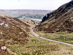
Butterlope Glen is a deeply incised glacial-meltwater channel, situated in Clogherny townland, County Londonderry. The site lies at the western end of the main Sperrin Mountain range about 4km north of Plumbridge. Butterlope Glen trends NNE-SSW and cuts across the regional strike and structure of the Sperrins. Access to the site is via Butterlope Road which runs southwards from a junction with the B48 [H490 954] at the northern end of the Glen and, via the Bradkeel Road, southwards to Glenelly. The rocks at Butterlope Glen form part of the Dungiven Formation, the uppermost lithostratigraphic interval in the Tayvallich Subgroup of the Argyll Group (Middle Dalradian), see table below. On the first edition of the one inch to one mile geological map (Newtown Stewart, Sheet 25) (Geological Survey of Ireland, 1886) and in the accompanying memoir (Wilkinson, et al., 1887) the rocks in Butterlope Glen are referred to variously as "mica schist, limestone and hornblende rock passing into schist". Hartley (1938) was first to propose a general lithostratigraphic subdivision of the Dalradian in the Sperrins and included strata at Butterlope within the Dungiven Limestone Group, subsequently revised and renamed the Dungiven Formation to conform with modern stratigraphic practice (Arthurs, 1976). This revised nomenclature remains in current usage. Various other aspects of the stratigraphy and structure of Butterlope have also been described in the geological literature (Gower (1972); Alsop et al., 1993). TABLE TO BE ADDED Dalradian stratigraphy and ESCR sites in the southern Sperrin Mountains. | |
| Description: | |
At Butterlope, rock outcrop extends for about 800m, mainly along the eastern side of the Glen where there is vertical exposure ranging from 20m to 40m high. The geological succession dips northwards and is structurally inverted so that progressively older strata occur down dip towards the north of the Glen. The youngest rocks outcrop beside the road at the hairpin bends at the southern end of the Glen. Here, silvery green and greyish green amphibolite schists (Glenga Amphibolite Member) represent the lowermost division of the stratigraphically younger Dart Formation. Northwards, down the Glen, the Glenga Member gives way to a mixed interbedded succession of quartz-biotite psammite and semipelite, amphibolite schist (green beds) with chert, stratified tuffs and locally graded hyaloclastite (Gower, 1972). High on the eastern face midway down Butterlope Glen, thick units of pink-buff coloured quartzite (with graded bedding) and micaceous psammite form the upright hinge of a large flat-lying, downwards facing (F3) fold. Typical limestones of the Dungiven Formation are best exposed in disused and partially filled quarry pits near the roadside about 200m from the northern entrance to the Glen. 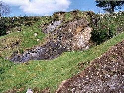 At the north end of Butterlope Glen, on the crags overlooking the farmhouse at [H491 954] there are several outcrops of highly deformed volcanogenic rocks. These include stretched pillow lavas interbedded with tuffaceous amphibolitic schist containing selvages of black chert and hyaloclastic shards?. | |
| Importance: | |
The importance of this site lies primarily in the excellent quality and variety of lithology and structural elements exposed within the relatively compact and accessible area of the Glen. There is in fact a strong case for Butterlope being designated as the formal stratotype for the Dungiven Formation. The site is important nationally in relation to establishing stratigraphic correlation between Dalradian successions within Ireland (Donegal, the Sperrins and North-east Antrim) and internationally between Ireland and Scotland. | |
| Interpretation: | |
The rocks in Butterlope Glen were deposited during an important transitional period that occurred towards the end of the Middle Dalradian and which also manifests itself at a comparable stratigraphic level in the Dalradian elsewhere in Ireland and in Scotland. During late Argyll Group (Tayvallich Subgroup) times, the continental crust at the margin of the Laurentian continent came under the influence of a developing extensional tectonic regime and the comparatively stable shelf depositional environments which had characterised much of Lower and Middle Dalradian times, gave way to less stable conditions. Crustal extension and thinning was accompanied by a major upsurge in basic volcanic activity and the eruption of basaltic lavas into comparatively shallow near shore marine sedimentary environments. This resulted in the intimate association of quartzite, limestone and basaltic pillow lavas with tuffaceous (volcaniclastic?) sediments that are characteristic of the Dungiven Formation. Structurally, the rocks at Butterlope Glen lie close to the axial region of the major NE-SW trending and SE facing overfold (F2). This structure formed during the Grampian Orogeny and is responsible for the inversion of the entire Dalradian stratigraphy in the southern Sperrins. Folding coincided with peak burial and during the Grampian was accompanied by lower amphibolite facies regional metamorphism. | |
| Conclusions: | |
For many years now Butterlope has been a first port of call and constant source of reference for geologists interested in the stratigraphy and structure of the Dalradian rocks of the Sperrin Mountains and wider areas. It is a site of considerable national and arguably international importance for which there is a strong case for conservation. | |
| Notes: | |
For site specific information and references on other Dalradian sites in the Sperrin Mountains, Londonderry and Tyrone see the following sites: For Central and Southern Sperrin Mountains: Key Site 131 - Craig Key Site 132 - Mullaghcarbatagh Key Site 133 - Henry's Bridge, Glensass Burn Key Site 134 - Oughtboy Burn Key Site 135 - Garvagh Burn Key Site 136 - Barnes Gap Key Site 137 - Barnes Burn Key Site 138 - Golan Burn Key Site 139 - Glendarragh Burn, Glenlark Key Site 140 - Mountfield Old Quarry Key Site 141 - McNally's Burn, Broughderg For North Sperrin Mountains and Londonderry: Key Site 142 - Letterbrat Quarry Key Site 143 - Banagher Glen Quarry Key Site 144 - Strabane Quarry Key Site 145 - Glenmornan River, Artigarvan Key Site 146 - Balix Hill Key Site 147 - Drain Quarry Key Site 148 - Kildoag Quarry Key Site 149 - Loughermore Mountain Key Site 150 - Burntollet and Tamnymore Wood Key Site 151 - Dog Leap, Limavady Key Site 152 - Kittybane Quarry Key Site 153 - Prehen Quarry Key Site 154 - Creevagh Hill Old Quarry For site specific information and references on other Dalradian sites in North-east Antrim see the following sites: Key Site 155 - Benvan Key Site 156 - Escort Port Key Site 157 - Torr Head Key Site 158 - Altmore Burn Key Site 159 - Leckpatrick Point Key Site 160 - Carnaneigh Key Site 161 - Loughan Bay Key Site 162 - Loughareema Channel Key Site 163 - Knocknacarry Bridge Key Site 164 - Cushendun Bay and Rock Port For general information on the Dalradian rocks of Northern Ireland see the following site: Key Site 124 - The Dalradian Rocks of Northern Ireland For general and site specific information on the Pre-Dalradian rocks of Northern Ireland see the following site: Key Site 123 - The Pre-Dalradian Rocks of Northern Ireland For general information and an extensive reference list on the Precambrian of Northern Ireland see the following site: Key Site 122 - An Introduction to the Precambrian of Northern Ireland This site is also important for Structural Geology. See Key Site 645 - Butterlope Glen. | |
| Keywords | |
|---|---|
| Rocks: | Lava, Limestone, Pillow lava |
| Access | |
|---|---|
| Approach: | Access to the site is via Butterlope Road which runs southwards from a junction with the B48 [H490 954] at the northern end of the Glen and, via the Bradkeel Road, southwards to Glenelly. |
| Management: | |
There is comparatively open access to most outcrops at Butterlope. The Glen is partially fenced and, because of the steep slopes is currently used as rough pasture only. Some tipping has taken place in the limestone quarries at the northern end of the Glen. Further tipping should be prevented as part of the longer term management of the site. It is not necessary to impose any restrictions to sampling at this site. | |
| Threats: | Tipping |
| Uses | |
| Uses: | Rough pasture |
| References (5) | |||
|---|---|---|---|
| Alsop, G.I. & Hutton, D.H.W., 1993. Major southeast-directed Caledonian thrusting and folding in the Dalradian rocks of mid-Ulster: implications for Caledonian tectonics and mid-crustal shear zones Geological Magazine, vol. 130 pt. 2, pp.233-244. | |||
| Arthurs, J.W., 1976a. The geology and metalliferous mineral potential of the Sperrin Mountains area Geological Survey of Northern Ireland Special Report. | |||
| Gower, P.J., 1972. The Middle-Upper Dalradian Boundary with special reference to the Loch Tay Limestone (Thesis) Unpublished PhD thesis, University of Liverpool. | |||
| Hartley, J.J., 1938. The Dalradian rocks of the Sperrin Mountains and adjacent areas in Northern Ireland Proceedings of the Royal Irish Academy, vol. 44 pt. B. | |||
| Wilkinson, S.B., Egan, F.W. & Kilroe, J.R., 1887. Explanatory Memoir to accompany Sheet 25 of the maps of the Geological Survey of Ireland Memoirs of the Geological Survey of Ireland. | |||
| Map(s): | GSI (1886). 1:63,360 Geological Sheet 25 (Newtown Stewart), Dublin, OS for GSI | ||
| Record type: | ESCR report | ||
| Entered by: | E M Porter | ||
| Last updated: | 8 Jan 2005 | ||
| Enlander, I., Dempster, M. & Doughty, P., 2026. Butterlope Glen - Dalradian, County Tyrone, site details. [In] Earth Science Conservation Review. https://www.habitas.org.uk/escr/site.php?item=130. Accessed on 2026-11-05. |
| Previous Site | Next Site |