
| Previous Site | Next Site |
Earth Science Conservation Review
| Barnes Burn - Dalradian | Tyrone |
| Site number: | 137 | ||
| ESCC: | EO | ||
| Locality Type: | Stream section | Status: | ESCR |
| Grid Reference: | H562905 Centroid | ||
| Google maps: | 54.75974,-7.127 | ||
| County: | Tyrone | Council area: | Derry City & Strabane District Council |
| Period: | Precambrian | ||
| Stages: | Dalradian | ||
| Lithostrat: | Clogherny Member, Glenelly Formation, Southern Highlands Group | ||
| Site Description | |
|---|---|
 | |
| Highlights: | |
Barnes Burn contains the stratotype (type section) of the Clogherny Member, a distinctive series of calcareous schists and psammites within the Glenelly Formation. The site also provides access to representative strata of the Glenelly Formation. | |
| Introduction: | |
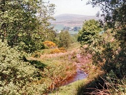
Barnes Burn is a deeply incised south-bank tributary of the Glenelly River. The Burn flows northwards through the townland of Upper Barnes before entering the Glenelly River at [H559912] approximately 8km east of Plumbridge. Access to the site is across pastureland from the Corramore Road which runs along the southern flank of Glenelly. The strata at this site are regionally metamorphosed metasedimentary rocks which form part of the Glenelly Formation of the Southern Highland Group (Upper Dalradian), see table below. They lie on the southern, inverted limb of a large NE-SW trending, SE facing F2 fold structure (the Sperrin Overfold). All the rocks in this area have a well-developed composite (S0-S3?) foliation broadly axial planar to this structure and consequently bedding and foliation of the strata at this site, dip consistently at about 45 degrees NW while overall, the succession youngs towards the south-east. On the first edition of the one inch to one mile geological map of the area (Sheet 26, Draperstown) (Geological Survey of Ireland, 1882) and in the accompanying memoir (Nolan, 1884), none of the rocks along the southern side of Glenelly including Barnes Burn, were differentiated from the general category of, "Chloritic, talcose & micaceous schists" of supposed Lower Silurian Age which was, with a few exceptions applied to all the metamorphic rocks in the Sperrin Mountains. Hartley (1938), who produced the first detailed litho- stratigraphic map of the Sperrin Mountains, included all the strata in Glenelly (including Barnes Burn) within a single division which he referred to as "Tourmaline Schists of Glenelly South". Arthurs (1976) redefined the boundaries of the principle Dalradian formation in the Sperrin Mountains and included the rocks in Barnes Burn within his revised Glenelly Formation. These revised boundaries, with minor modifications, form the basis of the Upper Dalradian stratigraphy for the second edition of the geological map Sheet 26 (Draperstown) (Geological Survey of Northern Ireland, 1995). TABLE TO BE ADDED Dalradian stratigraphy and ESCR sites in the southern Sperrin Mountains. The stratigraphic and structural model of the southern Sperrin Mountains favoured by Arthurs (1976) and the Geological Survey of Northern Ireland (1995) has recently been challenged by Alsop et al. (1993). They have included all of the formations in the South Sperrins, including the Glenelly Formation, in a single Sperrin Formation which belongs to the Argyll Group (Middle Dalradian) not the Southern Highland Group (Upper Dalradian). Current resurvey work carried out by the Geological Survey of Northern Ireland does not support this reinterpretation which has been challenged by Arthurs and Johnston & Smith (Arthurs et al., 1994). | |
| Description: | |
In Barnes Burn, for a distance of about 200m downstream from the Bridge at [H563 904], there is intermittent exposure of a mixed succession of lithologies typical of the Glenelly Formation. These strata include altered greyish green chloritic and grey sometimes graphitic, albitic micaceous semipelites with tourmaline and minor amounts of interbedded pale to off-white quartzose psammite. The Clogherny Member has an estimated stratigraphic thickness of 40m and consists of distinctive pale green to off-white quartz-mica schist and flaggy medium-grained to gritty quartzose psammite 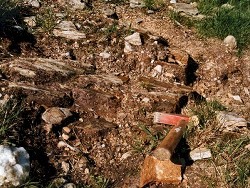 Further downstream, beyond the top of the Clogherny Member, outcrop is less abundant and consists mainly of chlorite-biotite-muscovite semi-pelitic flags. Locally, these beds contain quartz segregations and well developed feldspar (albite) porphryoblasts. | |
| Importance: | |
This site includes the designated stratotype (type section) of the Clogherny Member. This distinctive calcareous member is an important marker horizon which has been mapped along the southern side of Glenelly where otherwise the Glenelly Formation consists of a homogeneous succession of albitic semipelite and psammite. The ability to map such horizons in detail is crucial to the fuller understanding of the stratigraphy and structure of the Dalradian. | |
| Interpretation: | |
During Upper Dalradian times, the continental crust along the margin of Laurentia became unstable. Under the influence of a tensional tectonic regime, the crust thinned and fractured and a series of marine sedimentary basins developed along the continental margin. During Upper Dalradian times, these basins filled rapidly and subsided to accommodate large thicknesses of mainly siliciclastic turbidite facies sediments (Southern Highland Group, Glenelly Formation etc.). The fact that elsewhere in the Glenelly Formation, pale quartzose psammitic flags, similar to those in the Clogherny Member, are interbedded with thin mid-grey, graphitic schists indicates that the Clogherny Member probably represents an original facies variation. The Clogherny Member is one of three distinctive calcareous intervals within the Glenelly Formation. These calcareous horizons, which include both limestones and calcareous schists, indicate significant environmental and facies changes or variations within the Southern Highland Group. They represent the intermittent prevalence of shallower water, more oxygenated environments in which sediments underwent a greater degree of sedimentary sorting. During the late-Caledonian Orogeny, these sediments were deformed, folded and subjected to regional metamorphism. Metamorphic mineral assemblages typically include chlorite, biotite, muscovite and albite-oligoclase with tourmaline present as a characteristic accessory in semi-pelitic lithologies. Such mineral assemblages are consistent with the rocks having experienced Greenschist Facies conditions within the Barrovian Facies Series (Arthurs, 1976). Structurally, the Glenelly Formation lies on the overturned limb of the Sperrin Overfold. Consequently these strata dip towards the NW and young towards the SE. Primary way-up evidence is however rare in the Glenelly Formation because of the advanced state of recrystallization in the rocks. In this structural zone of the Sperrin Mountains, the rocks generally have a well developed schistosity defined by of a penetrative north-west dipping sometimes crenulating composite planar fabric (S1-S3?). | |
| Conclusions: | |
Barnes Burn is a geological site of national importance. It contains the listed stratotype (type section) for the Clogherny Member of the Glenelly Formation. Such lithologically distinctive horizons are comparatively uncommon in the Upper Dalradian succession in Northern Ireland and have an important role to play in establishing stratigraphic correlations on a regional, national or perhaps international scale. | |
| Notes: | |
For site specific information and references on other Dalradian sites in the Sperrin Mountains, Londonderry and Tyrone see the following sites: For Central and Southern Sperrin Mountains: Key Site 130 - Butterlope Glen Key Site 131 - Craig Key Site 132 - Mullaghcarbatagh Key Site 133 - Henry's Bridge, Glensass Burn Key Site 134 - Oughtboy Burn Key Site 135 - Garvagh Burn Key Site 136 - Barnes Gap Key Site 138 - Golan Burn Key Site 139 - Glendarragh Burn, Glenlark Key Site 140 - Mountfield Old Quarry Key Site 141 - McNally's Burn, Broughderg For North Sperrin Mountains and Londonderry: Key Site 142 - Letterbrat Quarry Key Site 143 - Banagher Glen Quarry Key Site 144 - Strabane Quarry Key Site 145 - Glenmornan River, Artigarvan Key Site 146 - Balix Hill Key Site 147 - Drain Quarry Key Site 148 - Kildoag Quarry Key Site 149 - Loughermore Mountain Key Site 150 - Burntollet and Tamnymore Wood Key Site 151 - Dog Leap, Limavady Key Site 152 - Kittybane Quarry Key Site 153 - Prehen Quarry Key Site 154 - Creevagh Hill Old Quarry For site specific information and references on other Dalradian sites in North-east Antrim see the following sites: Key Site 155 - Benvan Key Site 156 - Escort Port Key Site 157 - Torr Head Key Site 158 - Altmore Burn Key Site 159 - Leckpatrick Point Key Site 160 - Carnaneigh Key Site 161 - Loughan Bay Key Site 162 - Loughareema Channel Key Site 163 - Knocknacarry Bridge Key Site 164 - Cushendun Bay and Rock Port For general information on the Dalradian rocks of Northern Ireland see the following site: Key Site 124 - The Dalradian Rocks of Northern Ireland For general and site specific information on the Pre-Dalradian rocks of Northern Ireland see the following site: Key Site 123 - The Pre-Dalradian Rocks of Northern Ireland For general information and an extensive reference list on the Precambrian of Northern Ireland see the following site: Key Site 122 - An Introduction to the Precambrian of Northern Ireland | |
| Keywords | |
|---|---|
| Rocks: | Calcareous schist, Schist |
| Access | |
|---|---|
| Management: | |
The points of interest at this site lie entirely within the bed of Barnes Burn. The stream is currently partially fenced from surrounding pastureland with access via the fields from the Corramore Road, or, with some difficulty from the bridge at [H563 904]. In parts of the site, access to outcrop is difficult because of the deeply incised nature of the burn and overgrowing vegetation. The site does not appear to be under any immediate threat from development. Although there is evidence of a limited amount of dumping, none of this appears to be recent. Outcrops in the stream are relatively abundant and the site is capable of withstanding all reasonable sampling pressures. There is therefore is no need to impose special restrictions on sampling. |
| References (5) | |||
|---|---|---|---|
| Alsop, G.I. & Hutton, D.H.W., 1993. Major southeast-directed Caledonian thrusting and folding in the Dalradian rocks of mid-Ulster: implications for Caledonian tectonics and mid-crustal shear zones Geological Magazine, vol. 130 pt. 2, pp.233-244. | |||
| Arthurs, J.W., 1976a. The geology and metalliferous mineral potential of the Sperrin Mountains area Geological Survey of Northern Ireland Special Report. | |||
| Arthurs, J.W., Johnston, T.P., Smith, R.A., Alsop, G.I. & Hutton, D.H.W., 1994. Discussion on major southeast-directed Caledonian thrusting and folding in the Dalradian rocks of mid-Ulster: Implications for Caledonian tectonics and mid-crustal shear zones Geological Magazine, vol. 131 pt. 3, pp.417-421. | |||
| Hartley, J.J., 1938. The Dalradian rocks of the Sperrin Mountains and adjacent areas in Northern Ireland Proceedings of the Royal Irish Academy, vol. 44 pt. B. | |||
| Nolan, J., 1884. Explanatory memoir to accompany Sheet 26 of the maps of the Geological Survey of Ireland Memoirs of the Geological Survey of Ireland. | |||
| Map(s): | GSI (1882). 1:63,360 Geological Sheet 26 (Draperstown), Dublin, OS for GSI GSNI (1995). 1:50,000 Draperstown, Northern Ireland Sheet 26, Solid, BGS, Keyworth, Nottingham | ||
| Record type: | ESCR report | ||
| Entered by: | E M Porter | ||
| Last updated: | 23 Dec 2003 | ||
| Enlander, I., Dempster, M. & Doughty, P., 2026. Barnes Burn - Dalradian, County Tyrone, site details. [In] Earth Science Conservation Review. https://www.habitas.org.uk/escr/site.php?item=137. Accessed on 2026-11-05. |
| Previous Site | Next Site |