
| Previous Site | Next Site |
Earth Science Conservation Review
| Barnes Gap - Dalradian | Tyrone |
| Site number: | 136 | ||
| ESCC: | EO | ||
| Locality Type: | Crag, Crags | Status: | ESCR |
| Grid Reference: | H550900 Centroid | ||
| Google maps: | 54.75538,-7.14573 | ||
| County: | Tyrone | Council area: | Derry City & Strabane District Council |
| Period: | Precambrian | ||
| Stages: | Dalradian | ||
| Lithostrat: | Glenelly Formation, Southern Highlands Group | ||
| Site Description | |
|---|---|
 | |
| Highlights: | |
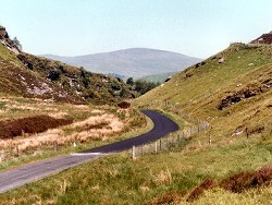
Barnes Gap is a deeply incised glacial overflow channel which contains high quality outcrop of typical strata of the Glenelly Formation (Southern Highland Group). The site offers an opportunity to study lithological and mineralogical variation within the Glenelly Formation and key structural elements related to Caledonian age folding. | |
| Introduction: | |
Barnes Gap cuts through the main ENE-WSW trending watershed which separates the Owenkillew Valley and Glenelly, approximately 7kms north-east of Gortin. The site is traversed by the Mullaghbane and Mullaghbrack Roads and lies, in part, on the route of the Ulster Way. Portlock (1843) referred to the bulk of the metamorphic rocks of the Sperrin Mountains, including Barnes Gap, as "mica schist". On the first edition of the one inch to one mile scale geological map (Draperstown, Sheet 26) (Geological Survey of Ireland, 1882) and in the accompanying memoir (Nolan et al., 1884) these rocks were referred to as "chloritic, talcose & micaceous schists, Lower Silurian, metamorphosed". Hartley (1938) published the first detailed lithostratigraphic map of the Sperrin Mountains and included the rocks at Barnes Gap within the division which he referred to as the "Tourmaline Schists of Glenelly South". On the second edition of the geological map (Geological Survey of Northern Ireland, 1995) rocks at Barnes Gap are included within the Glenelly Formation as defined by Arthurs (1976). The precise position of the Glenelly Formation within the lithostratigraphy and chronostratigraphy of the Dalradian Supergroup is summarised in table below. It should be noted that the stratigraphic and structural model of the southern Sperrin Mountains favoured by the Geological Survey of Northern Ireland has recently been challenged by Alsop et al. (1993). They have proposed that all the formations in the south Sperrins, including the Glenelly Formation, belong to a single unit (Sperrin Formation), which is, they suggest, part of the Argyll Group (Middle Dalradian) and not the Southern Highland Group (Upper Dalradian). However, this reinterpretation remains controversial and is strenuously challenged by Arthurs and Johnston & Smith (Arthurs et al., 1994). TABLE TO BE ADDED Dalradian stratigraphy and ESCR sites in the southern Sperrin Mountains. | |
| Description: | |
The glacial overflow channel that forms Barnes Gap [H550 900] exposes crags of greenish grey quartz-mica schist and semi-pelitic flags commonly composed of white mica, chlorite, quartz and plagioclase feldspar porphyroblasts. The main composite flaggy fabric (S1-S3) dips at about 40 degrees NW. Tourmaline is ubiquitous in these rocks in the form of randomly orientated needles which occasionally are bent and boudinaged. Thin quartz veins, representing early metamorphic segregations commonly define tight rootless folds within the main foliation. Some thicker quartz veins which are roughly parallel to the main foliation are boudinaged and some are associated with coarse segregations of pink plagioclase feldspar. In the small roadside quarry on the western side of Barnes Gap [H5504 8974], a bed of pale compact quartzite (0.26m thick) is intercalated with semi-pelitic flags containing white mica, chlorite, quartz, plagioclase and tourmaline together with some biotite and small euhedral garnets commonly preserved within plagioclase porphyroblasts. Structurally, the rocks at Barnes Gap lie on the inverted lower limb of a major overturned SE-facing fold. Consequently, all the strata are inverted and are overlain structurally by older strata (Dart Formation) to the north of Glenelly. The site contains clear examples of the principle structural elements within the south Sperrin Mountains. There is evidence of a strong composite S1-S3 foliation which has a consistent north-east to south-west strike and dips at 25-40 NW. Throughout the site the rocks also have a well-developed mineral stretching lineation (022 dipping 14NE) most evident in quartz grains. Well spaced flexures and kink zones (D4/5?) are also present throughout the area. The kink zones trend 070, stepping up and dipping at 80SE. | |
| Importance: | |
The importance of the Barnes Gap site lies primarily in the access that it offers to good quality outcrop of typical Glenelly Formation rocks in an otherwise poorly exposed area of the Sperrins. This allows geologists to examine several important lithological components of the Glenelly Formation together with important mineralogical variations and some key structural elements such as bedding/cleavage and cleavage/cleavage relationships. | |
| Interpretation: | |
The rocks at Barnes Gap were deposited during the Upper Dalradian, at a time when a tensional tectonic regime prevailed and was causing destabilisation of the Laurentian continental margin. During that time, sedimentary basins forming along the continental margin were infilled with sediments derived from the adjacent continental margin. Large thicknesses of clastic sediment accumulated in these basins where it was in part accommodated by syn-depositional basin subsidence. The Glenelly Formation contains a significantly higher percentage of argillaceous sediment than the stratigraphically older Dart Formation, indicating that the Glenelly Formation perhaps represents a more distal facies or was tapping a more mature sediment source. During the late-Caledonian Orogeny, deformation was accompanied by a regional (lower amphibolite facies) metamorphism, which transformed the original sedimentary protolith into the structurally complex, schistose metasedimentary lithologies found at Barnes Gap. | |
| Conclusions: | |
Barnes Gap lies on the route of the Ulster Way and is an area of outstanding beauty as well as significant geological interest. The site offers an excellent opportunity to study high quality outcrops representative of the Glenelly Formation together with important elements relating to the regional structure and metamorphism. | |
| Notes: | |
For site specific information and references on other Dalradian sites in the Sperrin Mountains, Londonderry and Tyrone see the following sites: For Central and Southern Sperrin Mountains: Key Site 130 - Butterlope Glen Key Site 131 - Craig Key Site 132 - Mullaghcarbatagh Key Site 133 - Henry's Bridge, Glensass Burn Key Site 134 - Oughtboy Burn Key Site 135 - Garvagh Burn Key Site 137 - Barnes Burn Key Site 138 - Golan Burn Key Site 139 - Glendarragh Burn, Glenlark Key Site 140 - Mountfield Old Quarry Key Site 141 - McNally's Burn, Broughderg For North Sperrin Mountains and Londonderry: Key Site 142 - Letterbrat Quarry Key Site 143 - Banagher Glen Quarry Key Site 144 - Strabane Quarry Key Site 145 - Glenmornan River, Artigarvan Key Site 146 - Balix Hill Key Site 147 - Drain Quarry Key Site 148 - Kildoag Quarry Key Site 149 - Loughermore Mountain Key Site 150 - Burntollet and Tamnymore Wood Key Site 151 - Dog Leap, Limavady Key Site 152 - Kittybane Quarry Key Site 153 - Prehen Quarry Key Site 154 - Creevagh Hill Old Quarry For site specific information and references on other Dalradian sites in North-east Antrim see the following sites: Key Site 155 - Benvan Key Site 156 - Escort Port Key Site 157 - Torr Head Key Site 158 - Altmore Burn Key Site 159 - Leckpatrick Point Key Site 160 - Carnaneigh Key Site 161 - Loughan Bay Key Site 162 - Loughareema Channel Key Site 163 - Knocknacarry Bridge Key Site 164 - Cushendun Bay and Rock Port For general information on the Dalradian rocks of Northern Ireland see the following site: Key Site 124 - The Dalradian Rocks of Northern Ireland For general and site specific information on the Pre-Dalradian rocks of Northern Ireland see the following site: Key Site 123 - The Pre-Dalradian Rocks of Northern Ireland For general information and an extensive reference list on the Precambrian of Northern Ireland see the following site: Key Site 122 - An Introduction to the Precambrian of Northern Ireland | |
| Keywords | |
|---|---|
| Minerals: | Garnet, Tourmaline |
| Rocks: | Pelitic rock, Schist, Semi-pelitic rock |
| Structures: | kink-fold |
| Access | |
|---|---|
| Management: | |
At Barnes Gap, much of the area of interest lies on unfenced or partially fenced ground comprising steep crags and rough pasture. This is a remote location where the extremes of slope and topography probably preclude most conceivable building development or radical change in land use. The points of geological interest occur throughout the area and there is no immediate need to protect the site from sampling. Attention should be drawn to potential dangers in accessing some of the crags high on the sides of the valley. Care should also be exercised when examining outcrops the face in the disused quarry at [H550 898] near to the northern end of Barnes Gap. |
| References (6) | |||
|---|---|---|---|
| Alsop, G.I. & Hutton, D.H.W., 1993. Major southeast-directed Caledonian thrusting and folding in the Dalradian rocks of mid-Ulster: implications for Caledonian tectonics and mid-crustal shear zones Geological Magazine, vol. 130 pt. 2, pp.233-244. | |||
| Arthurs, J.W., 1976a. The geology and metalliferous mineral potential of the Sperrin Mountains area Geological Survey of Northern Ireland Special Report. | |||
| Arthurs, J.W., Johnston, T.P., Smith, R.A., Alsop, G.I. & Hutton, D.H.W., 1994. Discussion on major southeast-directed Caledonian thrusting and folding in the Dalradian rocks of mid-Ulster: Implications for Caledonian tectonics and mid-crustal shear zones Geological Magazine, vol. 131 pt. 3, pp.417-421. | |||
| Hartley, J.J., 1938. The Dalradian rocks of the Sperrin Mountains and adjacent areas in Northern Ireland Proceedings of the Royal Irish Academy, vol. 44 pt. B. | |||
| Nolan, J., 1884. Explanatory memoir to accompany Sheet 26 of the maps of the Geological Survey of Ireland Memoirs of the Geological Survey of Ireland. | |||
| Portlock, J.E., 1843. Report on the Geology of the County of Londonderry and of parts of Tyrone and Fermanagh. HMSO, Dublin. | |||
| Map(s): | GSI (1882). 1:63,360 Geological Sheet 26 (Draperstown), Dublin, OS for GSI GSNI (1995). 1:50,000 Draperstown, Northern Ireland Sheet 26, Solid, BGS, Keyworth, Nottingham | ||
| Record type: | ESCR report | ||
| Entered by: | E M Porter | ||
| Last updated: | 23 Dec 2003 | ||
| Enlander, I., Dempster, M. & Doughty, P., 2026. Barnes Gap - Dalradian, County Tyrone, site details. [In] Earth Science Conservation Review. https://www.habitas.org.uk/escr/site.php?item=136. Accessed on 2026-11-05. |
| Previous Site | Next Site |