
| Previous Site | Next Site |
Earth Science Conservation Review
| Letterbrat Quarry, Plumbridge | Tyrone |
| Site number: | 142 | ||
| ESCC: | EA | ||
| Locality Type: | Quarry (working) | Status: | ESCR |
| Grid Reference: | H471923 Centroid | ||
| Google maps: | 54.77684,-7.26804 | ||
| County: | Tyrone | Council area: | Derry City & Strabane District Council |
| Period: | Precambrian | ||
| Stages: | Dalradian | ||
| Lithostrat: | Argyll Group, Newtownstewart Formation | ||
| Site Description | |
|---|---|
 | |
| Highlights: | |
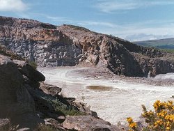
The working quarry at Letterbrat contains excellent exposures of some of the stratigraphically oldest rocks in the Sperrin Mountains. Coarse-grained granular psammites belonging to the Newtownstewart Formation are exposed throughout the quarry which also contains fine exposure of a massive transgressive porphyry sill intrusion. | |
| Introduction: | |
Letterbrat quarry is located on the eastern slope of Cruckaclady and is accessible via the Letterbrat Road, approximately 2km north-west of Plumbridge. This is a working quarry which exposes deep sections through the Newtownstewart Formation, a formation characterised by coarse-grained quartz-rich psammites. On the original one inch to one mile geological map (Sheet 25, Newtown Stewart (Geological Survey of Ireland, 1886, Wilkinson et al., 1887), the rocks at Letterbrat and in the surrounding area were not distinguished from the general category "Mica Schist passing into Gneiss" which was applied throughout the Sperrin Mountains. Hartley (1938) produced the first detailed lithostratigraphic map of the area and included rocks around Letterbrat within the "Schistose Grit Group of Dart" which he correlated with the Glen Sluan or Pitlochry Schists in Scotland. In the revised stratigraphy proposed by Arthurs (1976) the rocks at Letterbrat form part of the Newtownstewart Formation (Argyll Group, Middle Dalradian). The top of the Formation coincides with the base of the Dungiven Formation (base of the limestone band exposed on Balix Hill, see table below. The Newtownstewart Formation forms a thin wedge at the core of the Sperrin Overfold. The stratigraphic and structural model of the southern Sperrin Mountains favoured by Arthurs (1976) and the Geological Survey of Northern Ireland (1997) has recently been challenged by Alsop et al. (1993). These workers have suggested that the formations in this area belong to the Argyll Group (Middle Dalradian) and that the Newtownstewart Formation succeeds the Dungiven Formation stratigraphically and belongs to the Southern Highland Group. This reinterpretation of the regional stratigraphy and structure continues to be challenged (Arthurs et al., 1994). TABLE TO BE ADDED Dalradian stratigraphy and ESCR sites in the southern Sperrin Mountains. | |
| Description: | |
The site is a large working quarry and roadstone coating plant whose working faces are constantly changing as quarrying progresses. The quarry exploits a sequence of very hard, pale grey, quartz-psammites. The succession consists of very regular massively bedded psammite units up to 1m thick
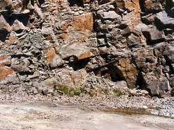 On the northern face of the quarry, the quartz psammite is cut by a 10-20m thick, purplish pink to reddish brown coloured porphyritic intrusion containing abundant euhedral phenocrysts (up to 1cm long) set in a fine-grained feldspathic matrix. White (weathering to pinkish buff) orthoclase feldspar is the most abundant phenocrystic mineral and is accompanied by silvery and greenish black to bronze coloured mica, irregular and rounded quartz and occasional hornblende. The intrusion also contains a thin scattering of pyrite cubes. This intrusion has an overall sheet-like geometry (dip 30° to 40°N). The intrusion outcrops on the floor of the quarry then transgresses southwards and progressively upwards until it reaches the top working bench some 30 metres above the quarry floor. This intrusion is one of suite of similar, distinctive porphyritic dykes and sills which outcrop in the area between Plumbridge and Donemana. Debris from these intrusions also features widely in the glacial tills and fluvio-glacial gravels in the upper parts of the valleys of Burn Dennett and Inver River. | |
| Importance: | |
This site is largely of local significance, offering as it does, good quality three dimensional outcrop of strata representative of the Newtownstewart Formation. In view of the extant controversy in relation to the stratigraphy of the Sperrins, and the location of this site in what is believed to be the core of the Sperrin Overfold, it is anticipated that this site will continue to generate interest. The coincidental presence of a major undeformed (post-Caledonian?) porphyry intrusion lends added interest to the site. At present, this intrusion, one of several which have been mapped in the surrounding area, is little understood and should be subjected to more detailed study to characterise the magma type and if possible the age of emplacement. | |
| Interpretation: | |
The outcrops at Letterbrat Quarry represent part of the Newtownstewart Formation, a thick succession of quartzo- feldspathic metasedimentary rocks deposited towards the end of the Middle Dalradian period. To date very little detailed stratigraphic mapping has been undertaken in this area and consequently little is known about their depositional environment. Following deposition, the rocks were deformed and subjected to a regional metamorphism. The presence of porphyroblastic biotite in the psammites and semipelites indicates quartz-albite-epidote- biotite sub-facies conditions within the Greenschist Facies. Metamorphism was accompanied by a marked increase in metamorphic crystallinity, especially in the psammite beds. This recrystallization appears to have overprinted and obscured almost all of the original sedimentary features in the rocks. Sometime after the main tectonic and metamorphic event, a period of igneous activity resulted in the emplacement of a number of porphyritic dykes and sills in the area. The age of these intrusions has not as yet been determined. No comparable intrusions have been recorded cutting Carboniferous strata in the nearby area which may point to a Devonian age (Arthurs, 1976). | |
| Conclusions: | |
The excellent exposures in this quarry provide a good opportunity, (in an otherwise poorly exposed area), to study lithological and structural details of the Newtownstewart Formation and the large porphyry intrusion. It is anticipated that this will be a site of key interest as the planned mapping of the Geological Survey of Northern Ireland extends into the area in the near future. | |
| Notes: | |
For site specific information and references on other Dalradian sites in the Sperrin Mountains, Londonderry and Tyrone see the following sites: For Central and Southern Sperrin Mountains: Key Site 130 - Butterlope Glen Key Site 131 - Craig Key Site 132 - Mullaghcarbatagh Key Site 133 - Henry's Bridge, Glensass Burn Key Site 134 - Oughtboy Burn Key Site 135 - Garvagh Burn Key Site 136 - Barnes Gap Key Site 137 - Barnes Burn Key Site 138 - Golan Burn Key Site 139 - Glendarragh Burn, Glenlark Key Site 140 - Mountfield Old Quarry Key Site 141 - McNally's Burn, Broughderg For North Sperrin Mountains and Londonderry: Key Site 143 - Banagher Glen Quarry Key Site 144 - Strabane Quarry Key Site 145 - Glenmornan River, Artigarvan Key Site 146 - Balix Hill Key Site 147 - Drain Quarry Key Site 148 - Kildoag Quarry Key Site 149 - Loughermore Mountain Key Site 150 - Burntollet and Tamnymore Wood Key Site 151 - Dog Leap, Limavady Key Site 152 - Kittybane Quarry Key Site 153 - Prehen Quarry Key Site 154 - Creevagh Hill Old Quarry For site specific information and references on other Dalradian sites in North-east Antrim see the following sites: Key Site 155 - Benvan Key Site 156 - Escort Port Key Site 157 - Torr Head Key Site 158 - Altmore Burn Key Site 159 - Leckpatrick Point Key Site 160 - Carnaneigh Key Site 161 - Loughan Bay Key Site 162 - Loughareema Channel Key Site 163 - Knocknacarry Bridge Key Site 164 - Cushendun Bay and Rock Port For general information on the Dalradian rocks of Northern Ireland see the following site: Key Site 124 - The Dalradian Rocks of Northern Ireland For general and site specific information on the Pre-Dalradian rocks of Northern Ireland see the following site: Key Site 123 - The Pre-Dalradian Rocks of Northern Ireland For general information and an extensive reference list on the Precambrian of Northern Ireland see the following site: Key Site 122 - An Introduction to the Precambrian of Northern Ireland | |
| Keywords | |
|---|---|
| Rocks: | Psammite |
| Access | |
|---|---|
| Management: | |
There are some special factors to bear in mind when considering conservation and subsequent management of this site. Since this is a working quarry, all faces should be regarded as being ephemeral and all remain under constant threat either by removal or covering by stockpile. Having said that, no particular part of the quarry need be regarded as warranting special attention It should be possible, with the agreement of the quarry owners, to set aside part of the quarry face where no further operations are anticipated and where safe controlled access to exposures of the Newtownstewart Formation and the porphyry intrusion can be maintained. |
| References (5) | |||
|---|---|---|---|
| Alsop, G.I. & Hutton, D.H.W., 1993. Major southeast-directed Caledonian thrusting and folding in the Dalradian rocks of mid-Ulster: implications for Caledonian tectonics and mid-crustal shear zones Geological Magazine, vol. 130 pt. 2, pp.233-244. | |||
| Arthurs, J.W., 1976a. The geology and metalliferous mineral potential of the Sperrin Mountains area Geological Survey of Northern Ireland Special Report. | |||
| Arthurs, J.W., Smith, R.A. & Johnston, T.P., 1994. Discussion on major southeast-directed Caledonian thrusting and folding in the Dalradian on mid-Ulster: implications for Caledonian tectonics and mid-crustal shear zones Geological Magazine, vol. 131 pt. 3, pp.417-421. | |||
| Hartley, J.J., 1938. The Dalradian rocks of the Sperrin Mountains and adjacent areas in Northern Ireland Proceedings of the Royal Irish Academy, vol. 44 pt. B. | |||
| Wilkinson, S.B., Egan, F.W. & Kilroe, J.R., 1887. Explanatory Memoir to accompany Sheet 25 of the maps of the Geological Survey of Ireland Memoirs of the Geological Survey of Ireland. | |||
| Map(s): | GSI (1886). 1:63,360 Geological Sheet 25 (Newtown Stewart), Dublin, OS for GSI GSNI (1997). 1:250,000 Northern Ireland, Solid Geology (2nd edition), BGS, Keyworth, Nottingham | ||
| Record type: | ESCR report | ||
| Entered by: | E M Porter | ||
| Enlander, I., Dempster, M. & Doughty, P., 2026. Letterbrat Quarry, Plumbridge, County Tyrone, site details. [In] Earth Science Conservation Review. https://www.habitas.org.uk/escr/site.php?item=142. Accessed on 2026-11-06. |
| Previous Site | Next Site |