
| Previous Site | Next Site |
Earth Science Conservation Review
| Strabane Quarry | Tyrone |
| Site number: | 144 | ||
| ESCC: | ED | ||
| Locality Type: | Quarry (disused) | Status: | ESCR |
| Grid Reference: | H349982 Centroid | ||
| Google maps: | 54.83084,-7.45691 | ||
| County: | Tyrone | Council area: | Derry City & Strabane District Council |
| Period: | Precambrian | ||
| Stages: | Dalradian | ||
| Lithostrat: | Argyll Group, Dungiven Formation, Tayvallich Subgroup | ||
| Site Description | |
|---|---|
 | |
| Highlights: | |
Strabane Quarry is a disused pit which contains the earliest recorded occurrence of pillow lavas (and associated green beds) in the Dalradian succession in Ireland (McCallien, 1936). Potentially, these lavas can play an important role in establishing local and wider stratigraphic correlations in the Dalradian succession of the Sperrin Mountains and further afield. | |
| Introduction: | |
Strabane Quarry is located about 0.6 km north-east of Strabane town centre and is accessed via Nancy's Lane, a residential cul-de-sac which joins the A5 Londonderry Road at [H346 983]. The quarry lies within a broader green bed horizon which extends northwards from Strabane towards Ballymagorry and forms part of the Dungiven Formation, see table below. On the first edition of the one inch to one mile geological map of the area (Sheet 17, Strabane) (Geological Survey of Ireland, 1888) the rocks at this site are represented as "mica schists". The original surveyors failed to differentiate "green beds" in the vicinity despite an earlier reference by Portlock (1843) to "greenstone slate" containing epidote (zoisite) at Hollywell near Strabane. Kinahan et al. (1889), in the memoir which accompanied the one inch Strabane Sheet, referred to Portlock's greenstone without making further comment. McCallien (1936) followed up Portlock's lead and, suspecting that these "greenstones" might represent a continuation of the green beds previously seen in north-east Antrim, discovered pillowed lava at Strabane and at nearby Artigarvan. McCallien (1936) published details of this discovery which he termed the "Strabane Pillow Lavas", claiming them as the first discovery of such rocks in the Dalradian of Ireland. Hartley (1938) and Arthurs (1976) have both referred to the possibility that the pillow lavas at Craig [H523 981] near Butterlope Glen correlate with the Strabane and Artigarvan lavas and that all form part of the Dungiven Formation (Argyll Group, Tayvallich Subgroup) exposed on either side of a major overturned antiformal structure (Sperrin Overfold). Although detailed knowledge of the stratigraphy and structural configuration of the area between Craig and Strabane/Artigarvan must await the completion of Geological Survey of Northern Ireland's current mapping of the area, this remains a reasonable working hypothesis on the basis of current knowledge. TABLE TO BE ADDED Dalradian stratigraphy and ESCR sites in the northern Sperrin Mountains. | |
| Description: | |
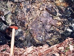
The rocks in Strabane quarry form part of a mixed "green bed" sequence dominated by pale green amphibolite schists. These rocks contain amphibole (hornblende), feldspar (albite), biotite, chlorite, zoisite, epidote, calcite with accessory sphene and pyrite (McCallien, 1936). Such an assemblages is consistent with metamorphism in the Greenschist Facies of the high pressure Barrovian Facies Series (Arthurs, 1976). The majority of outcrops in Strabane Quarry are moderately to strongly deformed with a well developed schistosity. This is a regionally persistent fabric (S2?) which, in the region of Strabane obliterates original sedimentological and morphological features in the finer grained (tuffaceous?) lithologies. Strabane Quarry is notable for the occurrence of pillow lavas. McCallien (1936) described these as feldspar- porphyritic and non-porphyritic varieties of massive pale green schists with feldspars occurring often as "knotty projections". The lavas are cut by quartz veins and veins containing epidote and asbestos. Remnants of sediments were also noted as streaks and irregular patches of dark "slaty material" along with dark coarsely crystalline limestone, particularly in the spaces between some of the best formed pillows. The best examples of pillow structures are found in the northern part of the quarry along the steep southern face of the entrance lane leading from the locked entrance gate and in a poorly exposed overhung outcrop at the base of the western face of the quarry. The exposures in the entrance lane correspond to the photographed locality (Fig.3. in McCallien's paper). | |
| Importance: | |
This site is important because it contains the first recorded occurrence of pillow lavas in the Dalradian succession in Ireland. Although several more pillow lava occurrences have been recorded in recent years, this locality remains important because of its location on the northern limb of the Sperrin Overfold. It has already been suggested, though not yet confirmed, that the Strabane lavas correlate with those at Craig [H523 981] (Dungiven Formation) on the southern limb of the Sperrin Overfold. The pillow lavas at Strabane Quarry therefore constitute a marker horizon which is likely to prove important to the developing understanding of the stratigraphy and structure of the Sperrin Mountains. Ongoing investigations including geochemical characterisation of Dalradian magmatism and scheduled mapping by the Geological Survey of Northern Ireland is likely to focus further attention on this site in the coming years. | |
| Interpretation: | |
The occurrence of pillow lavas and green beds in Strabane Quarry, in close association with limestone and coarse gritty psammite in the Strabane area constitutes strong evidence that these rocks form part of the Dungiven Formation or a stratigraphic equivalent. In Northern Britain and Ireland, across the entire Dalradian belt the stratigraphic interval represented by the Dungiven Formation and it's correlatives in Donegal (Culdaff Limestone) and Scotland (Loch Tay Limestone, Tayvallich Limestone) mark an important geological transition. Towards the end of Argyll Group (Middle Dalradian) times, the Laurentian continental margin, where comparatively stable shallow water shelf environments had prevailed throughout the Lower and Middle Dalradian, experienced a change in tectonic conditions. A newly established extensional tectonic regime caused crustal dilation and thinning. This was accompanied by a major period of basaltic magmatism during which pillow lavas erupted in shallow marginal marine basins and volcanic tuffs and volcaniclastic sediments became major components of sediment being deposited in the marginal basins. By the time this volcanism had waned sometime in the lower part of the Southern Highland Group (Upper Dalradian), a series of unstable, rapidly subsiding sedimentary basins had developed along the Laurentian continental margin. Initially, there was a strong volcanogenic component in the materials deposited in these basins but as time progressed, the basins were rapidly infilled with predominantly siliciclastic turbidite facies sediments which were in part accommodated by basin subsidence. | |
| Conclusions: | |
There is currently a very strong case to be made for conservation of this site on the grounds that it contains the first recorded occurrence of pillow lavas in the Dalradian succession in Ireland. It is envisaged that the site will continue to be a geologically important point of reference as the Geological Survey of Northern Ireland extends systematic studies of the stratigraphy and structure of the Sperrin Mountains and contiguous areas. | |
| Notes: | |
For site specific information and references on other Dalradian sites in the Sperrin Mountains, Londonderry and Tyrone see the following sites: For Central and Southern Sperrin Mountains: Key Site 130 - Butterlope Glen Key Site 131 - Craig Key Site 132 - Mullaghcarbatagh Key Site 133 - Henry's Bridge, Glensass Burn Key Site 134 - Oughtboy Burn Key Site 135 - Garvagh Burn Key Site 136 - Barnes Gap Key Site 137 - Barnes Burn Key Site 138 - Golan Burn Key Site 139 - Glendarragh Burn, Glenlark Key Site 140 - Mountfield Old Quarry Key Site 141 - McNally's Burn, Broughderg For North Sperrin Mountains and Londonderry: Key Site 142 - Letterbrat Quarry Key Site 143 - Banagher Glen Quarry Key Site 145 - Glenmornan River, Artigarvan Key Site 146 - Balix Hill Key Site 147 - Drain Quarry Key Site 148 - Kildoag Quarry Key Site 149 - Loughermore Mountain Key Site 150 - Burntollet and Tamnymore Wood Key Site 151 - Dog Leap, Limavady Key Site 152 - Kittybane Quarry Key Site 153 - Prehen Quarry Key Site 154 - Creevagh Hill Old Quarry For site specific information and references on other Dalradian sites in North-east Antrim see the following sites: Key Site 155 - Benvan Key Site 156 - Escort Port Key Site 157 - Torr Head Key Site 158 - Altmore Burn Key Site 159 - Leckpatrick Point Key Site 160 - Carnaneigh Key Site 161 - Loughan Bay Key Site 162 - Loughareema Channel Key Site 163 - Knocknacarry Bridge Key Site 164 - Cushendun Bay and Rock Port For general information on the Dalradian rocks of Northern Ireland see the following site: Key Site 124 - The Dalradian Rocks of Northern Ireland For general and site specific information on the Pre-Dalradian rocks of Northern Ireland see the following site: Key Site 123 - The Pre-Dalradian Rocks of Northern Ireland For general information and an extensive reference list on the Precambrian of Northern Ireland see the following site: Key Site 122 - An Introduction to the Precambrian of Northern Ireland | |
| Keywords | |
|---|---|
| Rocks: | Green beds, Lava, Pillow lava |
| Access | |
|---|---|
| Management: | |
This site is in an advanced state of neglect. The quarry appears to have remained unworked for a long time. The entrance has a locked gate and access is through breaks in the perimeter fence. The site is surrounded by housing developments and there is evidence of fly-tipping of building rubble, wrecked cars and miscellaneous waste. The quarry also appears to be used by local children for 'recreational' purposes. The entire site including the quarry faces and floor is overgrown with mature trees and thick undergrowth. This severely restricts both the amount of outcrop visible and the natural light to examine available outcrop, especially along the entrance lane where some of the best examples of pillowed lavas occur. This site will represent a challenge if it is to be conserved and further dumping is to be restricted. The key outcrops would benefit from clearance of vegetation although paradoxically such actions might open the site to further vandalism. Although overall, the site is capable of sustaining reasonable sampling pressures, there may be a case for restricting sampling over parts of the site especially if remedial works expose particularly good outcrops of the pillow lavas. | |
| Threats: | At present, the most likely threat to this site is from vandalism and from tipping and infill of the quarry. |
| References (5) | |||
|---|---|---|---|
| Arthurs, J.W., 1976a. The geology and metalliferous mineral potential of the Sperrin Mountains area Geological Survey of Northern Ireland Special Report. | |||
| Hartley, J.J., 1938. The Dalradian rocks of the Sperrin Mountains and adjacent areas in Northern Ireland Proceedings of the Royal Irish Academy, vol. 44 pt. B. | |||
| Kinahan, G.H., Wilkinson, S.B., Nolan, J. & Eagan, B.A., 1889. Explanatory Memoir to accompany Sheet 17 of the maps of the Geological Survey of Ireland Memoirs of the Geological Survey of Ireland. | |||
| McCallien, W.J., 1936. A note on Dalradian Pillow lavas Proceedings of the Royal Irish Academy, vol. 43, pp.13-22. | |||
| Portlock, J.E., 1843. Report on the Geology of the County of Londonderry and of parts of Tyrone and Fermanagh. HMSO, Dublin. | |||
| Map(s): | GSI (1888). 1:63,360 Geological Sheet 17 (Strabane), Dublin, OS for GSI | ||
| Record type: | ESCR report | ||
| Entered by: | E M Porter | ||
| Enlander, I., Dempster, M. & Doughty, P., 2026. Strabane Quarry, County Tyrone, site details. [In] Earth Science Conservation Review. https://www.habitas.org.uk/escr/site.php?item=144. Accessed on 2026-11-08. |
| Previous Site | Next Site |